
Eclipse: Autonomous Mapping System
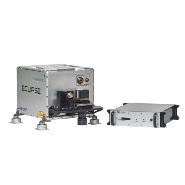
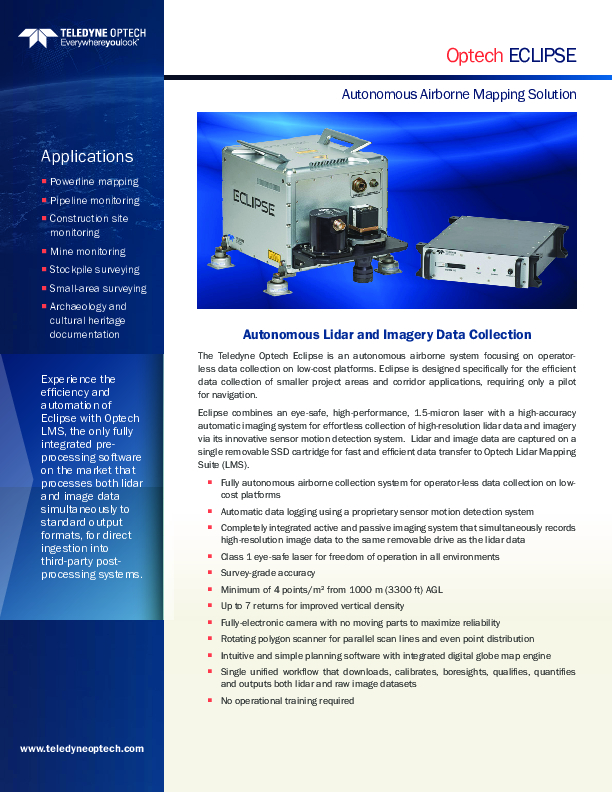
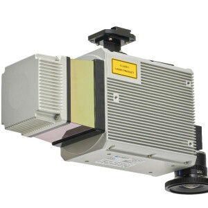
The Teledyne Optech Eclipse is an autonomous airborne system focusing on operatorless data collection on low-cost platforms. Eclipse is designed specifically for the efficient data collection of smaller project areas and corridor applications, requiring only a pilot for navigation. Lidar and image data are captured on a single removable SSD cartridge for fast and efficient data transfer to Optech Lidar Mapping Suite (LMS).
Teledyne Geospatial
Vaughan, CA
Description
The Teledyne Optech Eclipse is an autonomous airborne system focusing on operatorless data collection on low-cost platforms. Eclipse is designed specifically for the efficient data collection of smaller project areas and corridor applications, requiring only a pilot for navigation. Eclipse combines an eye-safe, high-performance, 1.5-micron laser with a high-accuracy automatic imaging system for effortless collection of high-resolution lidar data and imagery via its innovative sensor motion detection system. Lidar and image data are captured on a single removable SSD cartridge for fast and efficient data transfer to Optech Lidar Mapping Suite (LMS).
Do you have questions about this product?
- Questions about price, availability, and/or retailers
- Questions about technical specifications and usage
- Questions about suitability for your project or application
Specifications
-
General
-
Year of introduction
2016
Year of last update
2016
Total Weight [kg]
36.6
Power requirements
<200 W
Type of GNSS/INS positioning system
POSAV AP40
Camera
integrated electroic camera (29 MP)
Data storage facilities
removable SSD
Mission planning software
Yes
Postprocessing software
Lidar Mapping Suite
-
Application
-
Main applications
corridor; small-area; asset management; rapid response; agriculture; forestry; mining
-
Measurement Characteristics
-
Scanning method
Rotating polygon
Scan frequency [Hz]
140
Min. pulse frequency [Hz]
450000
Max. pulse frequency [Hz]
450000
Max. field of view [deg]
60
Max. number of recorded echoes per pulse
7
Full-wave form digitization
N
Pulse sampling frequency [GHz]
0
Recording of intensity of return signal [bits]
12
multiple pulses in air
Y
-
Operation Characteristics
-
Platform
Helicopter, Fixed-wing, Gyroplane
Min. flying height [m]
10
Max. flying height [m]
1000
Max. acquisition time [hr]
6
-
Laser Pulse Characteristics
-
Wavelength [nm]
1550
Standard pulse length [ns]
2
Beam divergence [mrad]
0.4
Type/class laser
Class I
Eyesafe range [m]
10
Pulse length variation [ns]
0
-
More information
-
Distinguishable features
One-button operation;No training required;Fully-automatic;Eye-safe;Single processing platform;Fully-supported with comprehensive warranty options
-
Uncertainty and resolution
-
Pitch and roll pointing precision [deg]
0.008
Heading pointing precision [deg]
0.02
Elevation precision at 1 km [m]
0.05
Planimetric precision at 1km [cm]
18
Across-track point spacing at 1km [m]
0.5
-
Application areas
-
Select an application area:
Documents
Brochure
migrationhtnyro.pdf
1.19 MB


