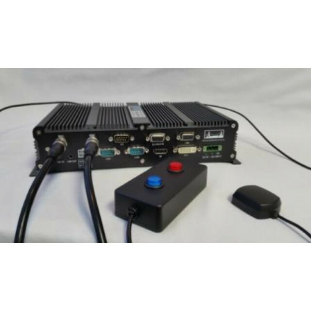
geoDVR & LineVision GIS Video Recording System
Remote Geosystems
Fort Collins, US
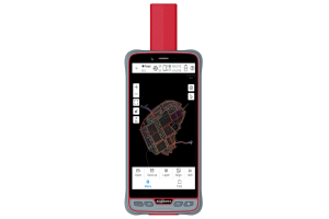
Description
Specifications
-
General
-
Year of introduction
2014
Main design elements
hardware and software
Total Weight [kg]
3
Width [m]
250
Height [m]
55
Depth [m]
150
Resolution: horizontal pixels
1920
Resolution: vertical pixels
1080
Display: width [m]
16
Display: height [m]
10
Touchscreen
Y
-
More information
-
Main applications
Electric Utilities - Infrared (IR) & Corona (UV) & High Definition (HD) Video Inspections Oil & Gas Pipeline PatrolsUAV & Unmanned SystemsTransportation & Rail Asset SurveysMobile Mapping & LiDAR
Distinguishable features
Connect most video cameras and gyro-stabilized gimbals to the geoDVR, and in seconds you are ready to start recording multiple HD geospatial full motion video files.
-
Software
-
Name of GIS package
LineVision Esri Maps, ArcMap Add-In, Google Earth
Zooming
Y
Panning
Y
Map rotation
Y
Editing of points
Y
Editing of lines
Y
Editing of polygons
Y
Editing of attributes
Y
Query
Y
Sketching of notes on map
Y
Display of external data and photos
Y
Measurements: length
Y
Measurements: area
Y
Import/Export Formats
.AVI, .GPX, .geoProject
Name of survey data collection software
geoDVR firmware
-
Connectivity
-
User Interfaces
stand-alone, touchscreen monitor
Wireless Data Transfer
Optional
Bluetooth
N
Ports
Ethernet
Compatible total stations
Open
WiFi
N
-
GNSS Receiver
-
GNSS Systems Supported
GPS (NMEA standards)
Number of Channels
3
Integrated SBAS
Y
Update Rate [Hz]
5
Time to first fix after cold start [s]
30
Multipath Mitigation
N
Compatible external GNSS receivers
Garmin, Trimble, NMEA Compatible Units
Stand alone positional accuracy [m]
5
Compatible GNSS correction signals
-
Computer
-
Processor
Intel i7
RAM [MB]
4000
Hard Disk
Solid State
Hard Disk [MB]
500
Types of Replaceable Memory
SSD
Built-in Camera: megapixels
0
Audio: speaker
Y
Audio: microphone
Y
Range measurement
Y
Operating System
Windows
-
Operation Characteristics
-
Integrated sensors
Compass
Operating temperature: min. [°C]
-40
Operating temperature: max. [°C]
70
Humidity resistance
0% RH - 95% RH
Shock proof
MIL-STD-810F, Method 516.5, Procedure I
Operation time per battery [hr]
24
Battery Field Replaceable
Y
Pole mount available
Y

