

EZSurv GNSS Post-Processing software
Effigis
Montreal, CA
Description
Specifications
-
General
-
Year of introduction
1991
Main design elements
software
-
More information
-
Main applications
EZSurv® is GNSS Post-Processing software that provides a reliable and efficient RTK offline solution to improve the accuracy of your survey or GIS data. Use EZSurv: - to play back your RTK survey for QA control (Post-Processed Kinematic – PPK) - to make corrections to non-RTK GNSS field data (Post-Processed Kinematic – PPK) - to calculate high accuracy baseline results (Static and Rapid Static) - to significantly improve GIS data accuracy EZSurv is a reliable and effortless solution that allows seamless data post-processing between different GNSS receiver native formats. This real value-added step can be easily integrated into your current RTK process or your GIS data integration loop. EZSurv is an open solution that processes GPS, GLONASS, GALILEO and BEIDOU signals from different types of receiver brands. It is compatible with industry standard data collection software.
Distinguishable features
FLEXIBLE TO BETTER MEET YOUR NEEDS As in RTK mode, EZSurv can either use your own base station data or automatically connect to more than 8,000 different base station providers. EZSurv is compatible with a wide range of GNSS receiver binary formats (without the need to convert to RINEX format). For kinematic GNSS post-processing, it is compatible with many GIS and Land Survey Mobile applications. Different licenses are available to better meet your specific needs.
-
Software
-
Name of GIS package
OnPOZ - EZSurv GNSS Post-Processing software
Zooming
Y
Panning
Y
Map rotation
N
Editing of points
Y
Query
Y
Import/Export Formats
Export baselines in GEOLAB format, SURVNET format, CSV files (custom format). Export trajectories in fix text format, CSV file (custom format). Export loop closure in CSV. Export sites in CSV format (custom format), DXF format. Export GIS features in Google Earth, ESRI Shapefile, DXF, CSV. Export raw data in standard RINEX format.
-
Connectivity
-
User Interfaces
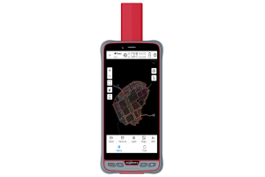
Plan View and Project Manager
-
GNSS Receiver
-
GNSS Systems Supported
GPS - Glonass - Galileo - BeiDou


