Mapping a Glacial Landslide Using a USV
Taan Fiord is an arm of Icy Bay in southeast Alaska. Over thousands of years, Tyndall Glacier eroded the valley walls creating very steep sidewalls. Over the past several decades, Tyndall Glacier has retreated, no longer supporting those sidewalls. The steepening and then debuttressing of the walls caused the sidewalls to collapse catastrophically in the form of a massive landslide. With a grant from the National Science Foundation, researcher Dan Shugar from the University of Washington Tacoma traveled with a team to investigate the damage caused by the landslide in the summer of 2016. The terrain and its inherent hazards and shallow areas posed significant challenges for both the team and the technology they would use to survey the region.
Remote Area Surveys with the Z-Boat 1800RP
BACKGROUND
In October 2015, a massive landslide was detected at Tyndall glacier in southeast Alaska, sending an estimated 145 million tons of valley wall into Taan Fiord. The landslide’s significant mass created a seismic signature detected by seismologists thousands of miles away at Columbia University in New York. Taan Fiord is an arm of Icy Bay in southeast Alaska. Over thousands of years, Tyndall Glacier eroded the valley walls creating very steep sidewalls. Over the past several decades, Tyndall Glacier has retreated, no longer supporting those sidewalls. The steepening and debuttressing of the walls caused the sidewalls to collapse catastrophically in the form of a massive landslide.

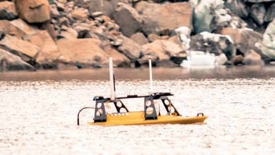
Doug Bonno, a student at the University of Washington Tacoma, operates the Z-boat from shore (Image Courtesy of Dan Shugar)
THE CHALLENGE
With a grant from the National Science Foundation, researcher Dan Shugar from the University of Washington Tacoma travelled with a team to investigate the damage caused by the landslide in the summer of 2016. The terrain and its inherent hazards and shallow areas posed significant challenges for both the team and the technology they would use to survey the region.
THE MISSION
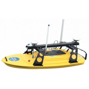
Shugar’s team, equipped with a new ruggedised Teledyne Oceanscience Z-Boat 1800-RP remotely operated unmanned surface vehicle, set out on an expedition into the affected area. The goals of that trip were to map the fjord floor with multibeam sonar and other seismic geophysical techniques that would allow them to see below the surface to determine the thickness of the landslide debris. Along with Shugar were a large group of scientists from Columbia University, the National Park Service, the University of British Columbia and elsewhere.

Z-boat surveying the Taan Fiord (Image Courtesy of Dan Shugar)
The team planned to map the submarine deposits with the UW-Tacoma’s Z-Boat 1800 RP named ‘Jökull’ (Icelandic for glacier) with help from Jeremy Venditti, a professor from Simon Fraser University in Canada, and Doug Bonno, an undergraduate student at UW Tacoma. Also on site was another much larger boat, the USGS Gyre, carrying larger instrumentation aboard, including a Teledyne Reson T50 and a couple of seismic systems.
The Z-Boat was equipped with a Teledyne Odom Hydrographic MB2 Multibeam sonar and an SBG Ekinox-D INS, which gave the team Real Time Kinematic (RTK) position as well as heave, pitch, and roll of the vessel. The RTK data were being broadcast from a Trimble R10 base station that Shugar’s team brought on the excursion. Shugar’s team performed velocity corrections and CTD measurements with an AML Oceanographic MinosX instrument. Each day, they set up a makeshift office comprised of a small table with a couple of chairs set on top of bouldery landside deposits on shore. A field laptop, power supply with solar panels, and radio antennas were used to communicate with the Z-Boat. The equipment was all powered by batteries, requiring the researchers to work efficiently in the wilderness.
THE OUTCOME
The Z-Boat was a useful tool, dodging icebergs and getting into areas too dangerous for the larger ship. “The Z-Boat was such a great tool for this particular project. We were working on a gigantic landslide in very steep terrain in front of a calving glacier, which is a pretty hazardous place to be around, so you don’t necessarily want to have a vessel with people aboard in this kind of environment. The slope that collapsed is potentially unstable even now, and so another landslide could occur. You don’t want to be too close to the calving face of the glacier because if a big piece comes off, it could generate a wave that might flip your boat,” explained Shugar.

Makeshift office on the landslide deposits (Image Courtesy of Dan Shugar)
“The Z-Boat allowed us to get into these otherwise inaccessible locations that the larger USGS boat wasn’t comfortable doing because it was too dangerous or potentially too shallow. We were able to fill in the gaps where the big boat didn’t want to go,” said Shugar.

(Image Courtesy of Dan Shugar)
Having the Z-Boat greatly increased the team’s chances of collecting important data and gaining access to remote locations.
“As a geoscientist that studies geohazards, in particular, the ability to go where we have never been able to go or map what we have never been able to map, with this kind of resolution, in these extreme environments and remote areas, is a tremendous advantage. Not only can we answer more profoundly scientific questions than we’ve been able to in the past, but also we can ask entirely new questions,” concluded Shugar.
Do you have questions about this case study?
Get in touch with Teledyne Marine, and they would be happy to answer any questions you have about pricing, suitability, availability, specs, etc.

![Do-Giant-Tortoises-Make-Good-Neighbors-1[1].jpg](https://cdn.geo-matching.com/vRMO2Edp.jpg?w=320&s=a6108b2726133ff723670b57bc54c812)


