Underwater Deadwood and Vegetation from UAV-borne Topobathymetric Lidar
The monitoring of submerged deadwood and vegetation is gaining increased attention due to their socio-economic and ecological importance. Deadwood acts as an important underwater habitat but also poses a threat to bridges, hydroelectric power plants and riverside buildings. Underwater vegetation, in turn, is a proxy for climate change in general and global warming in particular. In this context, UAV-borne topobathymetric laser scanning constitutes a promising tool for accurately capturing and modelling these small-scale objects in high spatial resolution.
Read the full article on gim-international.com
Deadwood acts as an important underwater habitat but also poses a threat to bridges, hydroelectric power plants and riverside buildings. Underwater vegetation is a proxy for climate change in general and global warming in particular. In this context, UAV-borne topo-bathymetric laser scanning constitutes a promising tool for accurately capturing and modelling these small-scale objects in high spatial resolution.
Sensor
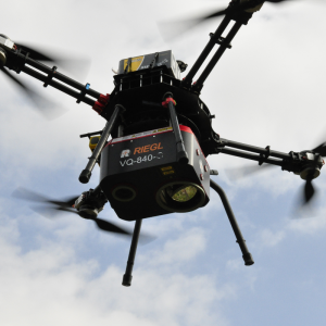
The RIEGL VQ-840-G is an integrated topo-bathymetric laser scanning system including a factory-calibrated IMU/GNSS system and a camera. The lightweight, compact VQ-840-G Lidar can be installed on various platforms, including UAVs. The laser scanner comprises a frequency-doubled IR laser, emitting pulses of about 1.5ns pulse duration at a wavelength of 532mrad and a pulse repetition rate of 50–200kHz. Onboard time-of-flight measurement is based on online waveform processing of the digitized echo signal. In addition, the digitized waveforms are stored on a disc for offline waveform analysis. The depth performance of the instrument is in the range of more than 2 Secchi depths.
Study Area and Dataset
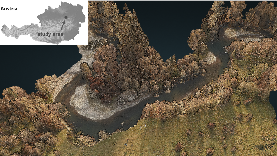
The study area is located at the tailwater of the pre-Alpine Pielach River, a tributary of the Danube River in Lower Austria. The study site is located in a Natura 2000 natural conservation area and the gravel bed river features a meandering course with frequent geomorphic changes in response to flood peaks. The area has been surveyed twice with the RIEGL VQ-840-G, first in November 2021 using the scanner mounted on an octocopter UAV operated by the Austrian service provider Skyability, and second in February 2022, when the scanner was mounted on a helicopter platform.
Both missions showed that the capture of submerged topography and the detection of complex features such as deadwood and submerged vegetation is possible in high detail. Based on the automatic classification of 3D points, it is now possible to quantify parameters of submerged deadwood (stem length and width) and littoral vegetation (vegetation height and volume).
Do you have questions about this article?
Get in touch with RIEGL | Innovation in 3D, and they would be happy to answer any questions you have about pricing, suitability, availability, specs, etc.

Related products


