
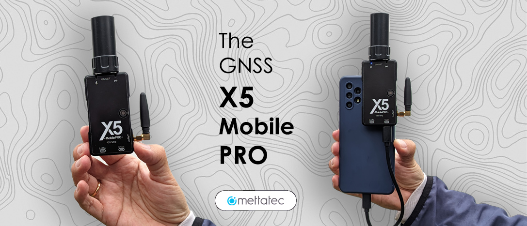
Introducing the Mini GNSS Receiver: X5 Mobile Pro
The X5 Mobile Pro is a GNSS receiver featuring cost-effective PPK, NTRIP, and RTK modes, designed to fit in your pocket, and delivering professional-grade performance.

ULTRA-PORTABLE SIZE
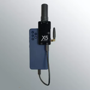
With an ultra-portable size of 84mm × 45mm x 15mm (without the HeliX5 multiband GNSS antenna and LoRa RTK antenna) and an ultra-light weight of 45 grams, users can easily store the X5 Mobile Pro in a pocket, briefcase or cartridge case and take it with them anywhere. In the same way, any cadastral or topography activity can be carried out very discreetly by being able to adhere to the cell phone, tablet or laptop (Android, iOS and Windows OS).

CENTIMETER ACCURACY
To ensure superior GNSS performance, the X5 Mobile Pro is equipped with a powerful U-Blox high-precision GNSS module with 184 channels for tracking all constellations: GPS, BEIDOU, GLONASS, GALILEO and QZSS, which provides centimeter positioning in any harsh environment. The 184 channels are more than enough to pick up signals from the approximately 122 geopositioning satellites currently in orbit (not all of them are visible from any location on Earth at any given time because they orbit the earth in a spatial distribution designed to supply service to almost the entire globe). Although to operate at a high precision level it has been shown that it is only required to be connected to 25 satellites.

POWERED BY THE CELL PHONE OR A POWERBANK
While not having an internal battery may seem an inconvenience, thanks to this feature the X5 Mobile Pro has a very small size, which allows you to work discreetly, even without attracting attention. The device is powered via the phone’s USB Type-C interface or a powerbank for uninterrupted work. Another advantage is that it can be shipped anywhere in the world without the current problems of restrictions by LiPo batteries in air transport and international shipments.

BLUETOOTH CONNECTION
Connect via Bluetooth and perform photogrammetric and surveying tasks such as surveys and stakeouts easily with your cell phone. The X5 Mobile Pro is compatible with survey applications and software or GIS with NMEA data.
DURABLE HOUSING
Considering the different outdoor working environments of users, the X5 Mobile Pro is designed with a 1.5m drop-proof housing and can also withstand extreme temperature working.
QUICK TO GET STARTED
Designed as an entry-level, yet high-precision RTK, the X5 Mobile Pro shows simple operation for all types of users and offers great convenience for professional surveyors. The user can start performing surveys in a few seconds after connecting it to the mobile.
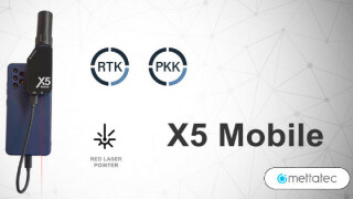
WORKING MODES: PPK, RTK AND NTRIP
As we know the X5 Mobile Pro is operated through a long list of compatible applications and software that work with NMEA data, using Bluetooth communication or serial USB cable. For example: SW Maps, FieldGenius, Survey Master, Mapit GIS / Mapit NTRIP Client, YCServer NTRIP Client, RTK camera, etc.
PPK MODE
In PPK (Post Processed Kinematic) data processing is required after capture, to obtain a centimeter level solution. It uses a GNSS receiver that acts as a base station measuring a fixed or known point, and a GNSS receiver that acts as a Rover capturing the points on the ground of the work area. One way to work in PPK mode with the X5 Mobile Pro is as follows:
Connect the X5 Mobile Pro to the mobile device or power it with a powerbank. The X5 can be attached to the same cell phone (in the case of photogrammetry) or preferably installed on a surveying stick with a known height.
Enable data transmission via Bluetooth or USB Serial Port.
Open the application to be used (for example: SW Maps App) and configure the application to work in PPK mode, that is, to save a log or file with the data captured during the operation time. For example, a UBX file.
Install the GNSS base station in a known and stable location. Power on and configure the GNSS base station to store the data in a file for further processing. For example, a UBX file.
Record GNSS observations continuously in the study area for the specified time.
Monitor GNSS signal quality during data collection.
Download the data stored by the X5 Mobile Pro receiver in the log file and the GNSS base station data in a log file after the mission.
Use specialized software to process PPK data, e.g. RTKLIB, Emlid Studio, etc. This processing will allow the data to be corrected based on the GNSS base station observations. That is, it will perform the kinematic calculation to obtain the precise coordinates of the points obtained in a final file, for example, a file with POS extension.

RTK MODE
In RTK (Real Time Kinematics) a data correction system is established that works in real time. Two GNSS receivers, a fixed base and a mobile rover, receive readings from the different satellite constellations available. But in this case, a constant data link is established between the Base and the Rover in real time so you can get that centimeter solution that we need. The data link is made via radio communication, and in the case of the X5 Mobile Pro internal LoRa radios of 1 Watt of power are used for radio communication. LoRa (which stands for Long Range) is a wireless communication technology that combines ultra-low power consumption with effective long range. Let’s use the GNSS X5 Receiver as a fixed GNSS Base for this example. One way to work in RTK mode with the X5 Mobile Pro is as follows:
Connect the X5 Mobile Pro to your mobile device or energize it with a powerbank. The X5 can be attached to the same cell phone (ideal for photogrammetry) or preferably installed on a surveying stick with a known height.
Enable data transmission via Bluetooth or USB Serial Port.
Open the Application to be used (for example: SW Maps App) and configure the application to work in RTK mode (In SW Maps indicate the u-Blox RTK mode). In this way, the X5 Mobile Pro activates the LoRa radio in correction receiver mode.
GNSS Base Configuration: Configure the GNSS X5 Receiver base station to transmit RTK corrections via 1 Watt power LoRa communication, using the FindX5 App operating mode selector.
Install the Base Station at a known and stable location, preferably at a point with known coordinates. Turn on the Base Station.
Ensure that the base station has a clear view of the sky for better reception of GNSS signals.
Once both receivers, in a few seconds, are connected to the minimum number of satellites required, a transmission mode of high-precision corrections will be established by going through three stages: Single, Float and finally Fix.
The X5 Mobile Pro achieves a horizontal and vertical accuracy of 1 centimeter (10mm).
Start field data collection with the X5 Mobile Pro as a Rover receiver. Record GNSS observations continuously as you move around the area of interest.
Monitor the quality of the LoRa signal and make sure that the connection between both devices is stable.
Download and Data Processing: Download the corrected data stored in the application of the mobile device after the mission.
In this working mode, thanks to LoRa technology, with the X5 Mobile Pro you can perform surveys within a radius of up to 10 kilometers with line of sight between the Base Station and the X5 Mobile Pro as a Rover.

NTRIP MODE
In NTRIP (Networked Transport of RTCM via Internet Protocol) a data correction system is established that works in real time but the transport of the data is done in RTCM format via Internet protocol. This mode of work is ideal for urban areas with cellular Internet or Wi-Fi coverage, since communication through RTK radio signals can be easily interrupted by physical obstructions in the field and by interference due to electrical networks or electronic devices. For the NTRIP technique to operate effectively, three essential components are required: a receiver in Base Station mode, a Caster server and a Rover receiver:
Base Station: In the context of NTRIP, continuously operating reference stations, also known as permanent stations or active bases, are commonly employed. These stations are usually GNSS receivers that function as precise reference points. In addition, NTRIP offers the possibility for users to establish their own network and use one of their GNSS receivers as a base station.
Caster Server: The Caster server is a specialized entity on the Internet that manages both the flow of data from the Base Stations and the authorization and administration of Rover users who want to connect to the network. The Caster server transfers RTCM data from Base Stations to one or more Rover receivers in the field, provided they are duly authorized. An illustrative example is the METTATEC CORS server (cors.mettatec.com), which offers free NTRIP correction services.
Rover receiver (For example: the X5 Mobile Pro): Finally, we have the receiver or receivers that the user or his team will use in the field to carry out their measurements. To use NTRIP, it is necessary to provide Internet access to the Rover receiver (and, if using your own base station, also to this one). This can be achieved using a SIM card, a mobile broadband device (BAM), a Wi-Fi connection, or by sharing an access point from a mobile phone or data collector. In the case of the X5 Mobile Pro, the receiver will use the Internet access of the mobile device to which it is connected to receive the correction data through the application used by the user (SW Maps, Survey Master, etc.)
One way to work in NTRIP mode with the X5 Mobile Pro is as follows:
Connect the X5 Mobile Pro to the mobile device or power it with a powerbank. The X5 can be attached to the same cell phone (ideal for photogrammetry) or preferably installed on a surveying stick with a known height.
Enable data transmission via Bluetooth or USB Serial Port.
Open the Application to be used (for example: SW Maps App) and configure the application to work in RTK-NTRIP mode (In SW Maps indicate the u-Blox RTK mode). In this way, the X5 Mobile Pro will enable the option of accessing NTRIP corrections over the Internet provided by the mobile device. If your mobile device does not have its own Internet access service, an external Internet connection must be enabled, either through a mobile broadband device (BAM) or Wi-Fi connection.
Selection of the CORS Base Station. Choose a CORS station close to the location of the survey. Access CORS station reference information, such as coordinates and contact details.
Configuration of the GNSS Software or Application. In the application selected on the cell phone, for example, SW Maps, enter the data of the selected CORS station, including the IP address, port, Mount Point and access credentials (if required). This will establish a connection to the Rover receiver so that it can access the NTRIP server.
The X5 Mobile Pro will receive corrections from the CORS station via NTRIP in real time.
Once the X5 Mobile Pro connects to the minimum number of required satellites and receives the corrections by NTRIP, a transmission mode of high-precision corrections will be established by going through three stages: Single, Float and finally Fix.
The X5 Mobile Pro in NTRIP mode achieves a horizontal and vertical accuracy of 1 centimeter (10mm).
Start GNSS Data Capture. Begin GNSS data capture in the field. Ensure that the Rover receiver has a clear view of the sky to receive GNSS signals.
Monitor GNSS signal quality and accuracy of NTRIP (FIX State) corrections while data is collected in the field.
Download and Data Processing: Once the data collection is finished, download the corrected data stored in the application of the mobile device after the mission.
In this working mode, thanks to NTRIP technology, with the X5 Mobile Pro you can perform surveys within a radius of up to 70 km between a CORS station and the X5 Mobile Pro as a Rover in NTRIP mode.

Do you have questions about this article?
Get in touch with METTATEC, and they would be happy to answer any questions you have about pricing, suitability, availability, specs, etc.
Related articles


