
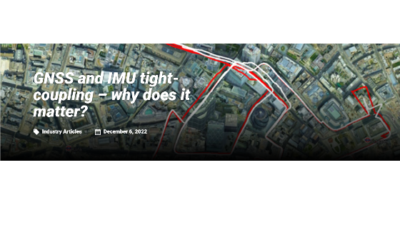
GNSS and IMU tight-coupling – why does it matter?
Increasingly, vehicle testing is moving from the proving ground to the public road. With the need for robotaxis to navigate dense urban environments and OEMs and Tier 1s to verify ADAS sensors and systems in urban and rural roads, accurate localisation has become one of the most significant problems facing automotive testing on the open road. In open-sky conditions, achieving centimetre-level accuracy is quite easy for a modern GNSS receiver. This is particularly true when using a base station or similar for corrections. It can, however, become difficult to maintain an accurate position fix when the sky is partially obscured. Buildings, trees, bridges, and other obstructions can therefore be problematic when testing on the open road.
Multi-path
Another problem, particularly in urban settings, is a tendency for satellite signals to be blocked completely or deflected by buildings. The reflected “multi-path” signals can cause significant errors in pseudo-range calculations and lead to errors in the reported position.
One way to get around this is to track more satellites. The recent additions of BeiDou and Galileo satellites have meant that GNSS receivers able to track these extra satellites have a significant advantage over older receivers that can only track GPS and GLONASS. If a receiver was tracking four satellites and one was available via a reflected signal, the receiver would need to use this bad signal. It would therefore need to calculate an incorrect position. Alternatively, it may discard it – and be unable to calculate a position from the remaining three satellites.
If instead, the receiver was able to track ten satellites, including one reflected signal, the data from the other nine may be sufficient for the receiver to realise the error in the tenth and discard it. In addition, even where multi-path is not an issue, tracking more satellites in any region of the sky makes maintaining visibility to the minimum number (four for SPS mode or six for RTK) of satellites easier when the sky is partially obstructed.

Do you have questions about this article?
Get in touch with Oxford Technical Solutions - OxTS, and they would be happy to answer any questions you have about pricing, suitability, availability, specs, etc.
Get in touch with Oxford Technical Solutions - OxTS, and they would be happy to answer any questions you have about pricing, suitability, availability, specs, etc.


