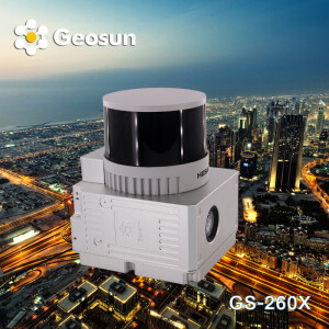


Unveiling Precision: S400E Drone & GS-260X LiDAR Test Flight
Exciting news from our latest test flight featuring the S400E Multi-payload drone paired with the GS-260X LiDAR scanning system! 🚀
We are thrilled to announce the successful capture of colorized point clouds and orthophotos in a single, seamless flight, showcasing exceptional precision and detail.
During LiDAR operations, the S400E drone demonstrated remarkable stability, executing smooth curve turns at each waypoint with precision and grace. This ensured the delivery of high-resolution, accurate data, essential for detailed terrain mapping and environmental analysis.
This innovative combination of drone technology and LiDAR scanning represents a significant leap forward in aerial surveying capabilities. Stay tuned for more updates and insights from our groundbreaking test flights!
Do you have questions about this article?
Get in touch with Geosun Navigation, and they would be happy to answer any questions you have about pricing, suitability, availability, specs, etc.

Related products


