![Do-Giant-Tortoises-Make-Good-Neighbors-1[1].jpg](https://cdn.geo-matching.com/vRMO2Edp.jpg?w=320&s=a6108b2726133ff723670b57bc54c812)


Applied BX305 GNSS RTK Boards for Land Survey and Aerial Photography
DS (abbreviation of the company) is a company which provides land survey and aerial photography service for northern NSW in Australia. Unlike other traditional survey practices, this company deploys survey grade GPS modules and drone technology to add ground control to verify positions.
"By leveraging L1/L2 GPS frequencies for accuracy and reliability, when fixed in RTK or PPK mode, their equipment provides centimeter absolute accuracy" Mr. Noble, Owner of DS
GPS Control Surveys
GPS control surveys are required to provide the best quality results on a universally known grid. Drone Surveying uses L1/L2 GPS frequencies for accuracy and reliability. When fixed in RTK or PPK mode, the BX305 equipment provides centimeter absolute accuracy. Once marks are placed, the locate these in the field. These marks are later identified with photogrammetry software to verify survey accuracy. Boundary marks and other features can be located. One GPS unit, the base, is established over a known station. A second unit, the rover takes concurrent measurements over the point to be located.
Real Time Kinematic (RTK)
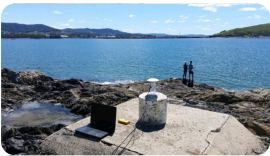
With Real Time Kinematic (RTK) the base transmits corrections to the river over UHF radio, a position is calculated on the spot. With Post Process Kinematic (PPK) both stations record data to memory, this is then processed in the office to obtain even more accurate results. In the image below the position of the mark has been calculated and the results are consistent to within 5mm. Results are tabulated for entry into the next stage of the survey.


