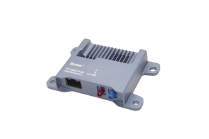

X26 GNSS/INS Combined Navigation System
Full-constellation Multi-frequency RTK Solution, L1 , L2, L5
X26 is a high-precision navigation unit based on self-developed GNSS chips. It has high-precision IMU which is compliant with functional safety ASIL B standards, and various interfaces. It is capble of tackling with harsh environments such as satellite signal interference or loss, providing stable, continuous, reliable high-precision position and atittudes.

Bynav Technology
Changsha, CN
Description
X26 features full-temperature calibrated IMU and deeply-coupled combined navigation algorithm. It is capable of providing reliable and accurate position in harsh environment such as satellite signal interference or loss.
With modeling based on the characteristics of autos and other vehicles, and optimation for relevent applications, X26 can produce high performance in various challenging scenarios including underground parking lots, tunnels, overpasses, urban streets, ports and so on.
Features
Deeply-coupled Combined Navigation Engine
The built-in high-precision IMU has been calibrated at full temperature, which improves key indicators like bias stability and dead reckoning accuracy. Aided by IMU, the deeply-coupled combined navigation algorithm can lift the quality of GNSS signal observation and increase the positioning accuracy by twice to 5 times than loosely-coupled algorithm.
High-precision GNSS Positioning Engine
Bynav REAL (Ransac Enhanced Advanced Location) GNSS positioning engine adopted has integrity monitoring and partial ambiguity solution algorithm to deal with various harsh environments such as satellite signal interference and outage and provide reliable and stable position in certain times.
Scalability
Multiple interfaces such as automotive ethernet and CAN/CAN FD are viable, also PPS and gPTP are supported to interact and work with other sensors like LIDAR and SLAM.
Scenario Optimization
Optimized for in-vehicle applications: based on vehicle characteristics modeling, it can handle the most challenging environments such as urban road canyon and satellite signal interference, providing continuous, stable and reliable real-time high-precision position.
Do you have questions about this product?
- Questions about price, availability, and/or retailers
- Questions about technical specifications and usage
- Questions about suitability for your project or application
Specifications
-
Performance
-
Tracked satellite signals
GPS: L1 C/A, L2, L5; GLONASS:G1, G2; BDS-2:B1I, B2I, B3I; BDS-3:B1I ,B1C, B2a, B2b, B3I; QZSS:L1 C/A, L2, L5; Galileo:E1, E5b, E5a; NavIC:L5


