
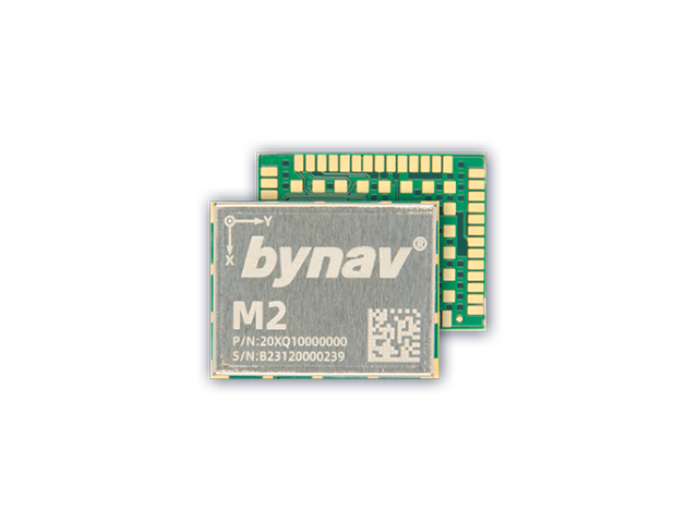


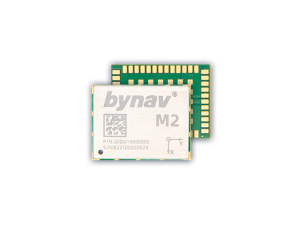
Bynav M21/22 GNSS/INS Module, 0.20% DR
L1 C/A,L1C,L2,L5,Full Constellation & Frequency GNSS Signal Solution
M21/22 is based on Alice, the new 22nm process high-performance automotive grade GNSS SOC from Bynav, with high-precision measurement and navigation engine, inertial navigation unit and functional safety processor, it can reach the functional safety ASIL B and support high-performance NRTK/PPP/PPP-RTK solution, deeply-coupled combined navigation, anti-jamming, L-BAND and CLAS SBAS.

Bynav Technology
Changsha, CN
Description
It can deal with harsh environments such as satellite signal interference and outage and provide continuous, real-time and reliable high-precision position. The module featuring high integration, high performance, low power consumption and small size can be applied to automatic driving, advanced driver assistance, lane-level navigation, drones, intelligent robots, precision agriculture, surveying, mapping and many other fields.
Deeply Coupled Combined Navigation Algorithm Performance improvement by 2 to 5 times
Functional Safety. Essential for intelligent driving
Anti-interference. Adapting to urban areas and interference environments
Satellite-based Augmentation Signal Reception
Full-system and Full-frequency
Combined navigation computing power and 1 P-Module can achieve PBOX functiona
Do you have questions about this product?
- Questions about price, availability, and/or retailers
- Questions about technical specifications and usage
- Questions about suitability for your project or application
Specifications
-
General
-
Depth [m]
0.022
Height [m]
0.00275
Total Weight [kg]
0.002
Width [m]
0.017
Type
Aerial, Land, Marine
-
Performance
-
No. channels
1507
Reacqisition time [s]
≤30S
Tracked satellite signals
BDS:B1I,B2I,B3I,B1C*,B2a,B2b*(PPP) GPS:L1C/A, L1C*, L2, L5 GLO:G1,G2 GAL:E1,E5a,E5b,E6* QZSS:L1CA,L1C,L2, L5,L6(CLAS) NAVIC(IRNSS): L5 SBAS*:L1C/A
-
Environment
-
Humidity resistance
95% non-condensing
Operating temperature: min. [°C]
-40℃
Operating temperature: max. [°C]
105
ROHS compliance
Y
-
Communication: general
-
Communication ports
UARTx4 SPI*x1 CANFDx2 WheelTickx1 ANT DETECTx1 GEOFENCEx1 PPSx1 FuSa*x2 EVENT_IOx5 RMIIx1
PPS Out
Y
-
Communication: Protocols
-
L-Band Compatible
Y
NMEA output format
Y
Other formats for differential data
RTCM
other output formats
BYNAV
RTCM standards for differential data
Y
-
Horizontal uncertainty
-
Initialization time on the fly [s]
≤5S
phase: RTK kinematic (variable part) [ppm]
1
-
Power
-
Certifications
AEC-Q104
Operating power: max. [V]
3.47
Operating power: min. [V]
3.13
Typical consumption [W]
0.5
-
More information
-
Distinguishable features
0.20% DR; AEC-Q104
Articles


