
SonarWiz 7 Field Data Acquisition Suite
Chesapeake Technology
Mountain View, US
Description
SonarWiz 7 Office Data Acquisition Suite includes sidescan, sub-bottom, bathymetry, magnetometry and single beam. SonarWiz Office Suite 7 is your all-in-one solution for processing sidescan, sub-bottom, bathymetry, magnetometry and single beam data. SonarWiz 7 Does-It-All Suite offers both data acquisition AND post-processing for single beam, sidescan, sub-bottom, bathymetry and magnetometry - which can be a useful combination!
Specifications
-
General
-
Year of initial development
1995
Year of latest version
2017
Operating System
Windows 7, 10
Area of Application
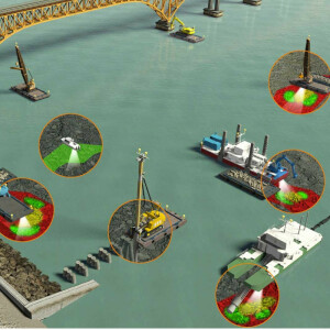
- Pipeline survey - Hydrographic survey - Commercial survey - Marine archaeological survey - Educational hydrography- Search and Recovery- Coastal Management- Biological habitat survey
-
Geodetic Functionality
-
Supported coordinate systems
Predefined like WGS84, LL, all UTM, NAD27, NAD83
Supported datum transformations
User-defined coordinate systems, to and from WGS84
Geographical coordinates (Lat, Long)
Y
Ground coordinates (E,N)
Y
Seven Parameter shift supported
Y
Time-dependent Transformation Parameters (14param)
N
Supported vertical reference frames
Any definable datum and ellipsoid
Ellipsoidal reference support (GRS80)
Y
Separation model for vertical datum shift support
Y
Local datum support
Y
Supported map projections
Those by GlobalMapper, plus user-defined options
-
Data / System Support
-
Recorded data storage formats
- C-Max (*.CM2) - CODA (*.COD) - EdgeTech (*.JSF) - eXtended Triton Format (*.XTF) - GeoAcoustics (*.GCF, *.RDF) - Humminbird (*.SON,, *.DAT) - HYPACK (*.HSX) - Imagenex SportScan (*.81S) - Imagenex Yellow Fin (*.872) - Imagenex DeltaT Backscatter (*.83P) - Klein - Including K5000 V2 (*.SDF) - Kongsberg EM Backscatter (*.ALL) - Kongsberg (Simrad) EA400/EA600 Backscatter (*.RAW) - Marine Sonic (*.MST,, *.SDS) - ProSAS (*.IMG) - QMips (.DAT, .QMP) - R2Sonic TruePix (*.R2S, *.XTF) - Reson 7000 Series Backscatter (*.S7K) - SeaBeam2100 (*.MB41) - Sonardyne Solstice (*.SWF8) - SWATHPlus Raw/Processed/Parsed (*.SXR/*.SXP/*.SXI) - Swedish Geo Survey (*.SEG) - Tritech (*.V4Log, LogDoc) Mag: - AquaScan AXL - Arts GAVIA MAG - Balaswamy - C&C Magnetometers - CSF Magnetometers - FSL-MAG - HWTMA-2011-1 - HYPACK RAW File Magnetometer - Lat Lon Magnetometer Files - Lon Lat Magnetometer - Mag Log Type 4 - Mag Log Type 5 - Maglog GPS-POS w/Altitude - Maglog GPS-POS-Alt-MAG2-MAG3 - Mag Log Spencer - Maglog Standard Format - Maglog w/Altitude - PLR Magnetometer [feet] - PLR Magnetometer [meters] - SeaLink Magnetometer - SeaLink Wilhelm - SeaSpy Type 3 - SonarWiz MAG 882 - SonarWiz SEASPY - SonarWiz SEASPY_XY - TBSmith HYPACK MAG - TeslaOffshore-MAG-1 - XYZ MAG See our website for the latest list: https://www.chesapeaketech.com/wp-content/uploads/2016/04/SonarWiz_Interfaces_and_FileFormats.pdf
Supported Hydrographic Systems
CMAX, Edgetech, Geoacoustics,Geomag, Humminbird, Imagenex, Klein, Knudsen, Kongsberg, Marine Magnetics, Marine Sonic,Odom, PingDSP, R2Sonic, RESON, SyQwest, Teledyne-Benthos, and Teledyne-Hugin. See our website for the latest list: https://www.chesapeaketech.com/wp-content/uploads/2016/04/SonarWiz_Interfaces_and_FileFormats.pdf
Supported AUVs
HUGIN, IVER, GAVIA
Supported ROVs
HUGIN, IVER, GAVIA
Supported ROTVs
HUGIN, IVER, GAVIA
Supported underwater positioning systems
USBL, GPS + cable-out, any NMEA-0183-based serial data system able to send COM or UDP port data
Supported multibeam systems
Edgetech 2205, 6205, Geoacoustics Geoswath, Imagenex Delta T, Klein 5900, Kongsberg EM2040, Lowrance Structurescan 3D, R2Sonic 2020, 2022, 2024, RESON with backscatter or snippets, RSON via HYPACK, Sea SWATHPLUS, WASSP Multibeam
Supported surface positioning systems
GPS, RTK, NMEA-0183-message-based, and more, sentence-based serial systems via COM or UDP port
Supported singlebeam systems
NMEA-0183 compliant supporting DBT/DPT; ISA500 $ISADS/$ISADA. Hypack ISA500-M39, MLG EASYNAV, .TXT
Supported sidescan sonar systems
CMAX, Edgetech 4125, 4200; Falmouth Scientific HMS-624 Swordfish; Humminbird, Kongsberg, Kongsberg-GeoAcoustics, Lowrance, Imagenex Sporstscan/Yellowfin, Klein 3000, 3900, 5000, 5000v2, 5900; Knudsen, Marine-Sonic HDS / Arc-Explorer, R2Sonic 2020, 2022, 2024, SonarBeam S-150, SyQwest Aquascan, Teledyne-Odom 1624 / 1625, Tritech Starfish 450/990, Seaking...
Supported magnetometer systems
AquaScan AX2000, GEM 19M, Geometrics 881/882, Marine magnetics - real-time; Any text-format for post-processing (template-based import)
Supported gyrocompass systems
Any NMEA-0183 sentence-based serial system via COM or UDP port
Supported motion sensor systems
Applanix POS MV, Novatel SPAN PASHR, Octans Benthos, Any TSS01-based serial sentence-based system via COM or UDP port
Supported sub-bottom Profiler systems
Edgetech SB216, 424, 2200, 2205; Falmouth HMS-622 ChirpCeiver; Kongsberg-Geoacoustics SB, CODA (import only), Innomar SES-2000, Klein 3000, Knudsen SB, Kongsberg, Mala GPR, Specialty Devices, SyQwest Bathy1020, Bathy2010PC, Hydrobox, Stratabox, Tritech SB, Teledyne Odom Chirp III, Echotrac....
Metadata management
Y
-
Online capabilities
-
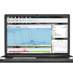
Helmsman display
Y
Max. number cloned displays
No limit
Supported background formats
ADRG FilesArc/Info ASCII GridArc/Info Binary GridArc/Info Export Format (E00)ASPRS LIDAR LAS FilesASRP (Arc Standard Raster Product) and USRP FilesASTER DEM and L1A/L1B Imagery and MODIS imageryAutoCAD DWG (DraWinG) FileAutoCAD DXF (Drawing Interchange File)BIL/BSQ/BIP ImageryBSB Nautical ChartsBT (Binary Terrain) Elevation Grid FilesCADRG and CIB FilesCanada 3D FilesCanadian Digital Elevation Data (CDED)CDF (GES Cartographic Data Format)CompeGPS RTE, TRK, and WPT FormatsDBF (DBase III+) FilesDHM - Swiss DEM FilesDTED (Digital Terrain Elevation Data) FormatErdas GIS FilesERDAS Imagine Image FormatERMapper Compressed Wavelet (ECW) FormatESRI ShapefilesGarmin PCX5 Format Waypoint (WPT) and Track (TRK) FilesGeodas Grid (GRD98) FormatGeosoft Binary Grid FilesGIF FilesGlobal 2' Elevation Data (ETOPO2)Global 30-arc-second Digital Elevation Data (GTOPO30)GLOBE (Global Land 1-km Base Elevation) DataGPS TrackMakerGPX (GPS eXchange Format) FilesGXF (Geosoft ASCII Grid) FilesHypack Matrix FilesIdrisi FormatIntergraph COT FormatInternational Bathymetric Chart of the Arctic Ocean (IBCAO) FilesJapanese DEM (JDEM) FormatJPEG Image with World FileJPEG2000 FilesKML/KMZ FormatsLandsat 7A FAST FormatLizardTech MrSID DataLowrance SonarViewer FormatLowrance USRMapInfo MIF/MID and TAB/MAP FormatsMapTech Topo Maps and Aerial Navigation ChartsMarplot MIE FilesMicroStation DGN FormatNIMA GNS (GeoNet Names Server) FormatNITF - National Imagery Transmission FormatNOAA DSDATA Geodetic Control, SDTS FormatNOAA TerrainBase Elevation DataNOS/GEO Chart FilesNTF Grid/Contour FormatOziExplorer Waypoint (WPT) and Track (PLT) FilesPGM Grayscale Grid FormatPlatte River ASCII Digitizer FormatPNG Image with World FileS-57 Digital Chart FilesSEGP1 Seismic Shotpoint FormatSMT KINGDOM Software Planimetric Polygon FormatSRTM (Shuttle Radar Topography Mission)Surfer Grid (ASCII and Binary) Format FilesTerragen Terrain FormatTerraScan .bin/.ts FormatTIGER/Line FilesUSGS Digital Elevation Model (DEM)USGS Digital Elevation Model, GeoTIFF FormatUSGS Digital Elevation Model, Spatial Data Transfer Standard Format (DEM/SDTS)USGS Digital Line Graph, Optional Format (DLG-O)USGS Digital Line Graph, Spatial Data Transfer Standard Format (DLG/SDTS)USGS Digital Orthophoto Quads (DOQ), GeoTIFF FormatUSGS Digital Orthophoto Quads (DOQ), JPG w/ Native Header FormatUSGS Digital Orthophoto Quads (DOQ), Native USGS FormatUSGS Digital Raster Graphic (DRG)USGS Geographic Names Information System (GNIS)USGS Land Use and Land Cover Data (LULC)USGS National Elevation Dataset (NED) - ArcGrid, BIL, Grid Float FormatVPF (VMAP0, VMAP1, DNC) FilesWAsP .MAP FormatZmap Plus Grid Files
Type of navigation screens
Helm DIsplay, left-right steering indicator, towfish altitude indicator, current GPS position system-info display (position, speed, heading)
Survey data types real-time navigation display
NMEA-0183 preferred (RMC, GGA, GLL) but any custom formats also supported, fro presentation in latitude/longitude, easting/northing, or X/Y display
Max number of online displayed ROVs
1
Max number of online displayed surface vessels
1
Computed orientation solution
Y
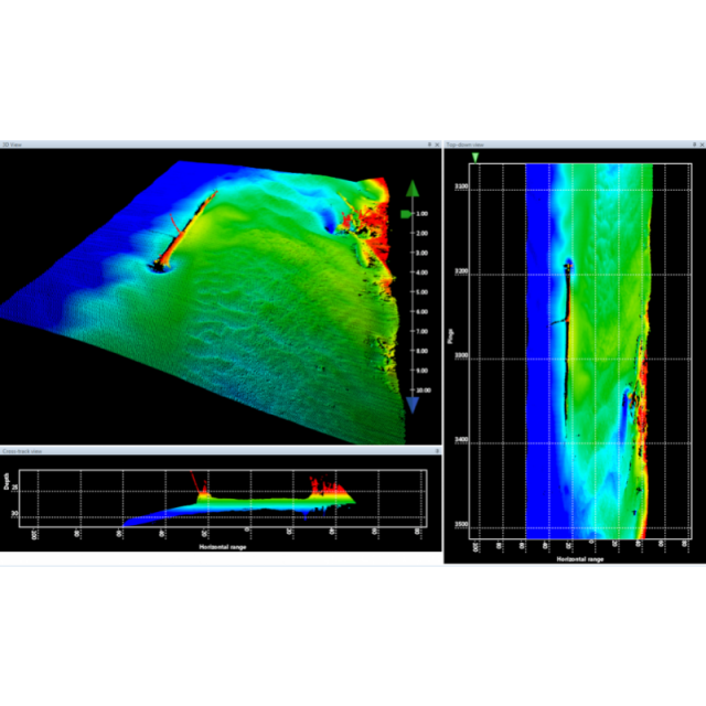
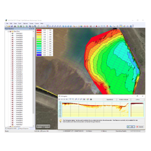
3D real time display
Y
Supported 3D display data
Y
RTK GPS height correction
Y
Real time video integration
N
Real-time Pipe detection
Y
Real time IHO / IMCA TPU support
N
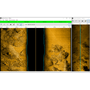
SSS waterfall display
Y
SSS target annotations
Y
Backscatter display
Y
Online filtering options
BAC, AGC, TVG, EGN
Status Views equipment
Position and altitude of towfish, ship; cable-meter view of cable extent
Online eventing
Y
Real-time DTM comparison
N
-
Hardware requirements
-
RAM
4000
HD (GB)
500
Processor (CPU)
32-bit, 64-bit
Languages Supported
English
Videos


