

Route Planning by Stratomaps
Geospatial solutions for safe, efficient and compliant drone missions
Navigate the airspace with Stratomaps’ advanced drone Maps and Geospatial Services. Stratomaps’ pathfinder algorithm compute the shortest 3D route for drones operating Beyond Visual Line Of Sight, while taking into account the topography, ground features, regulatory airspace restrictions and prohibitions of your mission zone.
Stratomaps
Description
Product:
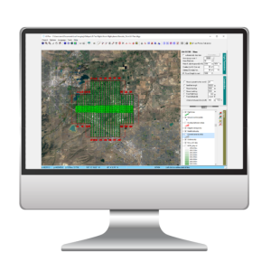
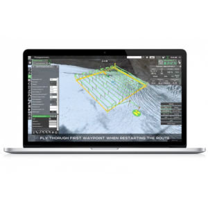
Custom Mission Zone: Operate a comprehensive set of aerial and ground data to gain knowledge of your operational environment.
Optimized routes: Generate efficient flight plans that factor in terrain elevation to minimize energy use. Avoid prohibited zones, populated areas and seamlessly integrate safety buffer zones, contingency zones, and operational volumes for safe and compliant navigation.
Simulation: Simulate your flight in a three-dimensional spatial scene allowing the vizualization of terrain, landscapes, structures, no fly zones with depth and perspective.
Benefits:
Improved mission safety: Minimize ground, air risks and optimize energy consumption with route planning that considers terrain profile, no fly zones and avoids populated areas.
Increased operational efficiency: Integrate safety buffer zones, contingency zones, and operational volumes into your planning for streamlined regulatory compliance.
Improved decision-making: Base your decisions on accurate, real-time data for optimal results.
Stratomaps is the drone Maps and Geospatial solution for operators who demand safety, efficiency and compliance. Contact us to find out how Stratomaps can improve your drone operations.
