

Map Services by Stratomaps
Access comprehensive geospatial data and interactive mapping tools for safer, more efficient drone missions.
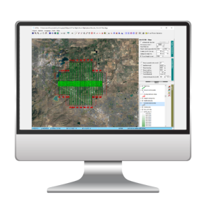
Stratomaps provides comprehensive data for your custom mission zone. Access a complete set of information essential to ground and air risk assessment.
Stratomaps
Description
Product:
Comprehensive data zones:
Digital terrain models (DTMs)
Building footprints and buffer zones
Prohibited zones (nuclear power plants, airports)
Restricted areas (time restrictions, military upper limits)
Civil aviation regulations
Ground obstructions (power lines, antennas)
Natural terrain features (forest canopy, nature reserve)
Roads and railroads
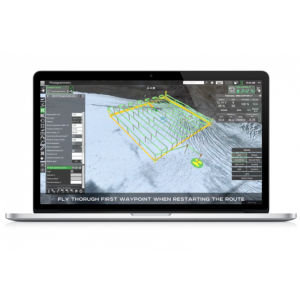
Interactive 3D mapping: Visualize your area of operation in detail with interactive 3D maps by displaying ground features, paths, corridors, operational volumes, restricted, prohibited and buffer zones.
Flight data extraction: Easily export your flight paths, zones and high-resolution Digital Terrain Model in various formats, directly usable by your ground control system.
Benefits:
Increased operational efficiency: Optimize your missions with interactive mapping tools and simplified flight data extraction. Make informed mission planning decisions with a complete interactive visualization of your area of operation.
Enhanced mission safety: Identify potential ground and air risks.
Flexibility and scalability: Custom data zones and features to your specific needs.
Stratomaps is the solution for creating comprehensive data zones and optimizing your drone mission planning. Contact us to find out how Stratomaps can improve your flight operations.
Documents
Other documents
-
Screenshot 2024-05-03 at 09.33.56.png2.12 MB
