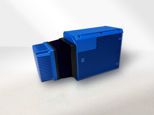

Description
Introducing JoLiDAR-1500: a state-of-the-art LiDAR measurement system with high-precision single-line laser scanner, self-developed inertial navigation, and point cloud fusion software. Perfect for multi-rotor drones, VTOL drones, helicopters, and more. Ideal for topographic mapping, powerline inspection, mining surveying, and real-world 3D applications. Empowering diverse industries with precise, efficient aerial data solutions.
JOUAV JoLiDAR-1500 LiDAR system covers all stages of data acquisition, data processing, and data management. It features long flight times, high accuracy, easy operation, fast data processing speed, and high operational efficiency. It can efficiently solve the mapping needs of large areas, complex terrain, and power inspection scenarios.
Specifications
-
Power
-
Power consumption
<55W
-
Application
-
Main applications
Surveying, Security
-
General
-
Lidar type
Mechanical rotation
Year of initial introduction
2023
Height [m]
0.252
Depth [m]
0.137
Width [m]
0.135
Total Weight [kg]
3.1
Certifications
Class 1 Safety Classification
-
Environment
-
Operating temperature: min. [°C]
-20
Operating temperature: max. [°C]
55
-
Laser and operation
-
Points per second
2 million points/sec
Eye-safe operation (Laser class)
Class 1 Safety Classification
Minimum detection range [m]
0
Maximum detection range [m]
1500
Resolution (number of scan lines, points per line, etc.)
9504*6336 (300 lines/sec)
-
Data output of one point
-
Range (distance)
1500


