
Scanfly EVO
The brand new, easy-to-use technology to capture reality!
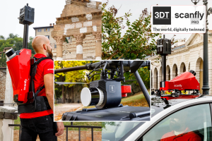
Unveiling the Scanfly EVO, the 3DT‘s entrylevel LiDAR mobile mapping solution. Building on a legacy that began in 2016, the EVO standsas the definitive multi-platform tool. Whether walking, driving, or flying, enjoy a seamless, tool-less, and cable-free experience. Ensure unparalleled value with every survey. Experience the EVOlution – Map effortlessy with Scanfly EVO!

3D TARGET
Castenedolo, IT
Description
Scanfly | The world digitally twinned
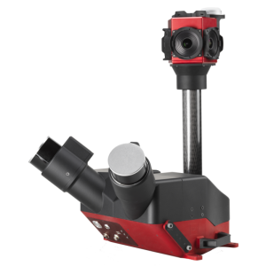
Up to 130 m range experience the EVOlution – Map effortlessy with Scanfly EVO! Powered by the brand new Hesai PandarXT-32
The Scanfly advantages:
Accurate Applanix INS APX-15L (IMU/GNSS)
Multi-platform, tool-less mounting accessorie, cable free design
24-62 MP Sony cameras, 60.5 MP NCTech iStar Pulsar panoramic camera
Ground control points, strip alignment tool and SLAM enabled
CE Marking Ingress, Protection IP55
Lidar integration
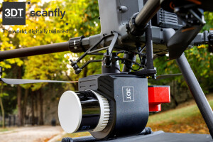
Multirotor drone
Backpack mount
Car mount
Key features
High resolution
Calibrated reflectivity
SmartProcessing Lidar Software
Your point clouds, at their best!
Intuitive Graphical User Interface
Efficient direct geo-referencing engine
Point clouds exported with intensity and RGB data
2D maps, 3D preview and quality diagrams
Full support to geographic reference systems
Ground control points and strip alignment tool
SLAM tool to increase accuracy in bad GNSS conditions
Blurring tool for faces and license plate
Do you have questions about this product?
- Questions about price, availability, and/or retailers
- Questions about technical specifications and usage
- Questions about suitability for your project or application
Specifications
-
Power
-
Power connector
56-pin Multi I/O Interface
Internal power supply (battery)
YES
Operating voltage (V)
24
Power consumption
30W (typical)
-
Application
-
Main users
THE MULTI-PLATFORM MAPPER
Main applications
Smart mobility, Surveying
-
General
-
Certifications
IP55 / CE
Depth [m]
1.42
Height [m]
1.33
Housing Material
Aluminium
Total Weight [kg]
1.6
Width [m]
1.81
Year of initial introduction
0
Lidar type
Mechanical rotation
-
Environment
-
Operating temperature: min. [°C]
-10
Operating temperature: max. [°C]
40
Water sand and dust proof (IP-classification)
IP55 / CE
-
Laser and operation
-
Points per second
1280000
Laser/light wavelength [nm]
905
Eye-safe operation (Laser class)
Class 1
-
Software and data processing
-
Data processing
SCANFLY SmartProcessing Lidar
Available SLAM algorithms
YES
Available point classification algorithms
YES
Available sensor fusion solutions
YES
Other available software
SCANFLY WebApp, SCANFLY SmartSurvey
-
Interface
-
Other data connectors
Embedded WiFi
Documents
Brochure
scanfly-evo
Videos

