
GIS Editor
General-purpose desktop GIS toolset.
Professional, general-purpose desktop GIS application for geospatial data creation, editing, mapping, modeling, and analysis, supporting a great number of data formats and coordinate systems. Powerful built-in Python scripting engine enables customization and adding new features as plug-ins.
TatukGIS
Gdynia, PL
Description
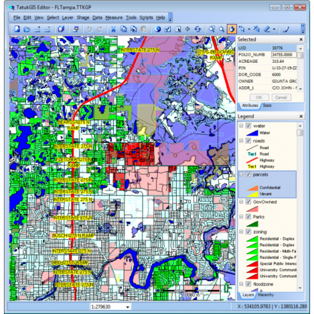
The TatukGIS Editor is a professional, general-purpose desktop GIS application for geospatial data editing, creation, mapping, modeling, and analysis, providing the set of features and tools most GIS users require. A powerful built-in Python scripting IDE can be used to implement customizations and features extensions as plug-ins.
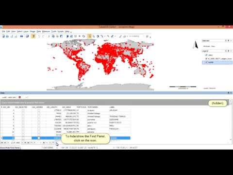
The Editor natively reads/renders 75+ geospatial industry vector, image, grid, and database layer formats and writes/exports to 35+ data formats, including advanced spatial databases such as PostGIS, Oracle Spatial, MSSQL Spatial and most others. A dedicated data panel displays layer attribute information in grid form with data editing and SQL query and spatial selection tools that work interactively with the map.
Comprehensive visual layer properties, legend, scale, north arrow and other controls, extended line style editor, sub-layers, layer grouping, etc., enable customization of every aspect of the map appearance for building sophisticated multi-layer projects. Other features include editing tools for vector geometry and attributes, vector snapping, topological error correction, 5,000+ predefined coordinate systems, on-the-fly layer reprojection and rectification, buffers, advanced filters, SVG map symbols library, color ramps, binning and dynamic shape aggregation, data classification methods, layer statistics, raster algebra engine, vector-to-grid interpolation algorithms, viewshed & above-ground-level (AGL) visibility analysis, slope analysis, point cloud-to-grid conversion, operation pipelining, GPS tracking, database joining, mini-map window, 3D visualization, printing, and much more.
The TatukGIS Editor is the same as free TatukGIS Viewer product but with important additional features relating to editing/creating data, spatial databases and DB joining, 3D visualization, scripting/customization, and layer rectification. See the Editor/Viewer feature comparison for details.
Volume discounts are available.
Specifications
-
Data management
-
Security options for access
Y
Search on file content
Y
Version management
Y
Spatial reference system
Selectable, From data source, Manual georeferencing
-
Geometry types
-
Raster
Reference
Lines
Line segment, Polyline, Multiline, Arc, B-spline
Points
Symbol, Point, Multipoint, Text
Surfaces
Polygon, Circle, Multipolygon, Others
-
Other
-
License or freeware
License
Training
Y
Main users
GIS users in any industry.
Main applications
TatukGIS Editor application is used in a wide range of industries for many purposes involving geospatial data creation, mapping, analysis, and operations.
Related products
The free TatukGIS Viewer is the same product as the TatukGIS Editor except for certain omitted features, and can be used as a trial version.
Distinguishable features
Easy-to-learn-and-use, comprehensive features, reasonably priced, built-in scripting IDE for power users, support for spatial databases (PostGIS, Oracle Spatial, ArcSDE ...)
Extensions
Many extensions (plug-ins) are available and new ones can be created by users.
-
2D Editing
-
Coordinate transformations
5,000+ coordinate systems supported, with on-the-fly vector/raster layer reprojection. Support reflects EPSG codes and OpenGIS WKT definitions.
Mosaicing
Mosaic both raster and vector layers, with rectification.
Select
Spatial selection, Select by administrative attributes, Within buffer, Multiple select, Others
Remove
By select, By attributes, By layer
Graphic transformations
Rotate, Scale, Copy, Move
Generalization
Yes.
-
2D Construction
-
Positioning by coördinates
Y
Positioning by snapping
Y
Positioning in relation to other element
Parallel, Perpendicular, Particular angle, Angle bisector, Tangent, Others
-
Storage
-
Native storage format
75+ vector/image/grid geospatial data formats supported natively (i.e., without import/export or any transcoding)
Input formats
Dwg, Dxf, Dgn, Shape, GML, KML, GeoTiff, ECW, SID, Jpg, Others
Export formats
Dxf, Shape, GML, KML, GeoTiff, Jpg, Others
GML version
Native read and write support for GML data format.
Compression
Y
Type of data storage
File, Database, Internet, Public cloud, Private cloud
-
Visualisation
-
Temporal
Yes. Managed via attribute data. Time lapse presention.
Types
Gradient color, Color, Pattern, Hatch
Change view
Zoomfactor, Target point, Twist angle
Thematic mapping
Contour map, Choropleth, Dot distribution map, Proportional symbol map
-
Interoperability
-
Web standards
WMS, WMTS, WFS
Spatial database management systems
Oracle, PostGIS, SQLite
Messaging protocols
XML
Publish standards
KML
Extensions
none
Available API’s
Built-in scripting environment exposes, within the Editor, the comprehensive API of the TatukGIS Developer Kernel (SDK), with hundreds of classes & thousands of methods and properties designed for professional GIS development.
Metadata
None
-
General
-
Year of introduction
2005
Year of last update
2023
Supported hardware
Computers running Windows (32 and 64 bit). No extreme hardware requirements..
Supported operation system
Windows
Main GIS category
Desktop GIS
-
Data analysis
-
Clip
Y
Merge
Attribute table to geometry, Map layers
Buffer
Polygon buffer, Point buffer, Line buffer, Dissolve buffers, Multiple buffers
Overlay operations
Union, Intersection, Symmetrical difference, Difference, Spatial join


