GIS Developer Kernel
Professional GIS library for multiple development platforms.
Professional grade, general-purpose GIS SDK used in a wide range of industries to develop custom geospatial applications and solutions. The SDK is available as multiple product editions, each compiled natively for a particular development platform (Delphi/C++Builder, .NET, ASP.NET, ActiveX, Java, and Python), providing the means to develop GIS using just about any programming language and for just about any operating system and the web.
TatukGIS
Gdynia, PL
Description
The TatukGIS Developer Kernel (DK) is a set of professional grade, general-purpose GIS libraries used in a wide range of industries to develop custom GIS applications or add geospatial functionality to existing products. Each library (i.e., DK edition) is compiled natively for a particular development platform, e.g., Delphi/C++Builder, .NET, ASP.NET, ActiveX, Java, and Python, offering the tools to develop GIS solutions using just about any programming language and for just about any operating system and the web.
Each DK library is highly similar, sharing the same object-oriented API with roughly hundreds of classes and thousands of documented methods and properties providing comprehensive geospatial functionality. Differences are only as required by the different technologies, resulting in highly similar application source code across platforms (see comparative code example) and relatively easy migration between platforms and operating systems.
The DK agnostically supports most geospatial industry data formats. Native support for more than 70 formats is compiled into the DK library. Dozens more formats are supported via external drivers. Advanced spatial databases such as PostGIS, Oracle Spatial, MSSQL Spatial, etc. are supported. Reading and writing each format is direct, so without involving any internal or TatukGIS specific data format.
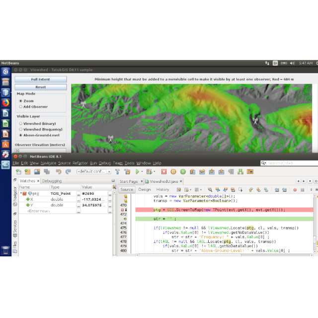
Features include powerful layer properties, legend, scale and other visual controls, 5,000+ predefined coordinate systems, on-the-fly layer reprojection, SVG symbols library, vector editing tools, spatial and SQL queries, filters, thematic mapping, data classification methods, raster algebra engine, layer statistics, binning and shape reduction, viewshed and AGL visibility analysis, vector-to-grid interpolation algorithms, point cloud-to-grid conversion, grid analysis, slope analysis, hydrology toolset, operation pipelining, topological operations, address geocoding/reverse geocoding, GPS tracking, routing, 3D visualization, and compatibility with industry standards.
The DK is licensed per developer, with no deployment royalties or run-time fees. Licensing is by product edition for a particular development platform or as an Enterprise package aggregating support for all available platforms and advanced spatial databases.
Specifications
-
Data management
-
Security options for access
Y
Search on file content
Y
Version management
Y
Spatial reference system
Selectable, Manual georeferencing, From data source
-
Geometry types
-
Raster
Reference
Lines
Line segment, Polyline, Multiline, B-spline
Points
Symbol, Point, Multipoint, Text
Surfaces
Polygon, Circle, Multipolygon
-
Other
-
License or freeware
License
Training
Y
Main users
Used by GIS software developers in a wide range of industries to develop custom GIS applications and add GIS functionality to existing products.
Main applications
GIS applications used in a wide range of industries: telecommunications, utilities, infrastructure asset management, civil engineering, logistics, forestry, agriculture, environmental engineering, mining, off-shore and naval, oil and gas, police and public safety, military, traffic management, geo-marketing, cadastral mapping, geophysical survey ...
Related products
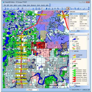
The desktop TatukGIS Editor and free Viewer products are excellent examples of applications developed/compiled from the TatukGIS SDK. Use to evaluate the DK performance, support for data formats, coordinate systems, and many other features.
Distinguishable features
Comprehensive API for GIS development, multi-platform development, support for multiple operating systems, native support for wide range of data formats, reasonable royalty-free licensing.
Extensions
Support for advanced spatial databases (e.g., PostGIS, Oracle Spatial, etc.).
-
2D Editing
-
Coordinate transformations
5000+ predefined coordinate systems, with on-the-fly vector/raster layer reprojection. Support reflects EPSG codes and OpenGIS WKT definitions.
Mosaicing
Yes. Raster and vector layers.
Generalization
Yes.
Select
Spatial selection, Select by administrative attributes, Within buffer, Multiple select, Others
Remove
By select, By attributes, By layer
Graphic transformations
Scale, Copy, Rotate
-
2D Construction
-
Positioning by coördinates
Y
Positioning by snapping
Y
Positioning in relation to other element
Parallel, Perpendicular, Particular angle
-
Storage
-
Native storage format
70+ vector/image/grid geospatial data formats and most spatial databases supported natively (i.e., without import/export to/from any internal format),
Input formats
Dwg, Dxf, Dgn, Shape, GML, SKP, GeoTiff, ECW, SID, Jpg, Others
Export formats
Dxf, Shape, GML, KML, GeoTiff, Jpg, Others
GML version
Native read & write support for GML format.
Compression
Y
Type of data storage
Database, File, Internet, Public cloud, Private cloud
-
Visualisation
-
Temporal
Using attribute data. Time lapse data rendering.
Types
Gradient color, Color, Pattern, Hatch
Change view
Zoomfactor, Target point
Thematic mapping
Contour map, Choropleth, Dot distribution map, Proportional symbol map
-
Interoperability
-
Web standards
WMS, WMTS, WFS
Spatial database management systems
Oracle, PostGIS, SQLite
Messaging protocols
XML, REST
Publish standards
KML
Extensions
Available API’s
API contains roughly 750 classes and 19,000 documented methods & properties designed for professional GIS application development.
Metadata
None
-
General
-
Year of introduction
2000
Year of last update
2023
Supported hardware
Compiled applications can run on Windows, Linux, macOS, iOS (iPad and iPhone), and Android. Web applications for hosting on Windows, Linux, and macOS servers.
Supported operation system
Windows, Mac OS X, Linux, Other
Main GIS category
Enterprise GIS, Desktop GIS, Internet GIS, Mobile GIS
-
Data analysis
-
Clip
Y
Merge
Map layers, Attribute table to geometry
Buffer
Polygon buffer, Point buffer, Line buffer, Multiple buffers, Dissolve buffers
Overlay operations
Spatial join, Intersection, Union, Symmetrical difference, Difference
Related products


