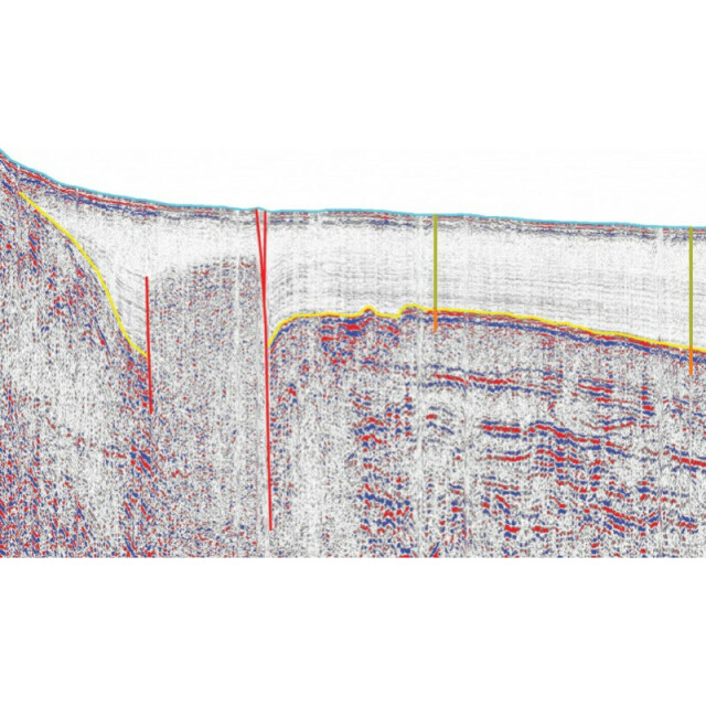
Triton Perspective-SBP
ECA Group Triton Imaging software suites have been designed to meet the needs of every phase of the survey project.
Triton Imaging
Capitola, US
Description
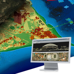
ECA Group Triton Imaging software suites have been designed to meet the needs of every phase of the survey project. ECA Group Triton Imaging offers both sonar-based software suites designed to meet the different needs of each sonar type, plus vehicle-based software suites assembled to meet the special needs of AUV and ROV surveying. Whether the application is mine hunting, port security, or other in the subsea survey industry.
Specifications
-
Hardware/software requirements
-
RAM [MB]
2000
HD{GB}
500
Processor
[]
Field of Use
To plan and conduct high-resolution seismic and subbottom profiler surveys and to process and interpret collected data.
Languages Supported
English, Russian, more coming soon!
-
General
-
Year of last update
2015
Year of initial introduction
1983
Modules
SB-Interpreter., Perspective Map, BathyOne, PFM Area Editor, Geocoder, SeaClass, MosaicOne, TargetOne,
Supported Systems (SB, MB, SSS, Lidar etc.)
Sub-Bottom profiler, Multibeam Echosounders, Side Scan Sonar,, Interferometric Sonars, Synthetic Aperture Sonar, Singlebeam Echosounders
-
Processing
-
Sound velocity correction
Sound velocity correction type
Time
Tidal reduction
Support tidal reduction network
N
Gridding/Interpolation techniques
Cell based, CUBE, Binning
Grid attributes {Std., Mean, Max, etc.}
average, RMS, min, max, first, last, standard deviation, density, uncertainty, number of hypothesis
Lay-back correction
Y
Siant range correction
Y
Mosaic creation
Y
Mosaic creation algorithms
ECA Group Triton Imaging own development
SSS Targeting
Y
Video integration
Y
Number of video channels
1
Assessment of bathymetry IHO Cat S-44
Y
Type of automatic cleaning algorithm(s)
Cube, beam suppression filters
Multibeam water column imaging support
Y
Multibeam Backscatter Processing Functionality
Y
Mulitbeam Calibration mehods
Automatic and Manual
Manual editing capability
Y
-
Geodetic Functionality
-
Supported coordinate systems
Use Proj4 libraries for support of most predefined coordinate systems, with user-defined 7 parameter coordinate system and customized datum options.
Geographical Coordinates {Lat, Long}
Y
Ground Coordinates {E,N}
Y
Seven Parameter shift supported
Y
Supported vertical reference frames
Y
Separation model for vertical datum shift support
N
Local datum support
Y
Ellipsoidal reference support (GRS80)
Y
-
Product Generation
-
Automatic top of pipe calculation
N
Slope analysis
N
Dynamic event numbering
Y
Automatic cross profile creation
N
Volume calculation
Y
Contouring
Y
Sounding Selection methods
N
Export/Exchange options
ASCII, HTF, GSF, XML, BAG, GeoTIFF, DXF, KML, SEGY, IVS SD
Combining bathymetry / terrestrial point clouds
N

