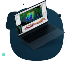
SonarWiz Field & Office Bathymetry
Bathymetry Multibeam
SonarWiz Bathymetry contains all the tools you need to calibrate, edit and render your bathymetric data, including support for AUV surveys with post-process navigation and attitude injection tools.
Chesapeake Technology
Mountain View, US
Description
BATHYMETRY
SonarWiz Bathymetry contains all the tools you need to calibrate, edit and render your bathymetric data, including support for AUV surveys with post-process navigation and attitude injection tools. SonarWiz has special support for geophysical and exploratory surveying offering
6 different gridding algorithms, volumetric and difference calculators, grid interpolation, and vector contouring. Export data to more than
20 supported GIS and CAD formats.
IMAGE PROCESSING
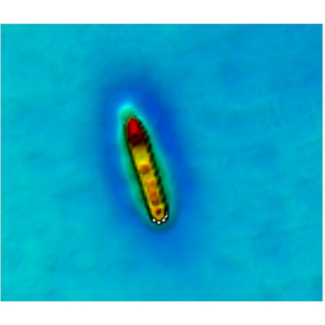
SonarWiz processes the acoustic backscatter simultaneously with the bathymetric soundings. This means that you can switch between rendering bathymetry or acoustic backscatter on the fly in any of the editors or displays. SonarWiz utilizes statistical normalization algorithms on the imagery optimized for habitat classification and mosaic generation. The algorithms are designed to work on any system including older uncalibrated sonars, interferometric sidescan systems, even damaged systems. Use the Seabed Characterization Tool to segment your survey before ground truthing.
VISUALIZATION
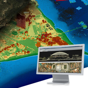
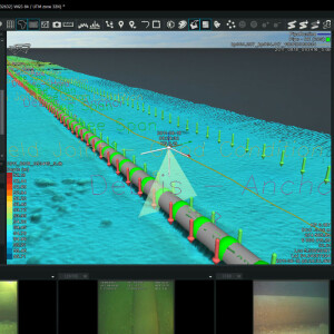
SonarWiz contains interactive 3D visualization tools where bathymetry and acoustic backscatter can be easily combined with sidescan and sub-bottom profile (SBP) data to make impressive visualizations of your survey area.
LICENSING
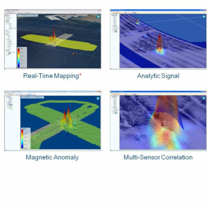
Sidescan and Sub-bottom (SBP) are available standalone. Bathymetry (Bathy) and Magnetometry (Mag) are available as add-ons, or bundled in various configurations. Office Suite includes post-processing for Sidescan, SBP, Bathy and Mag. Field Suite includes acquisition for Sidescan, SBP, Bathy and Mag. Field & Office Suite ("Does It All") includes both post-processing and data acquisition for Sidescan, SBP, Bathy and Mag. Network and Education licenses available.
SUPPORTED INTERFACES
Analog sonars: C-Max, Edge Tech, GeoAcoustics, Klein: digital sonars such as Atlas NA. C-Max, Edgetech, Falmouth Scientific, GeoAcoustics, lmagenex, Klein, Knudsen, Kongsberg, R2Sonic, SyQuest, Teledyne, Tritech
FILE FORMATS: JSF, RDF, RFF, HSX, HS2, HS2X, 83P, SDF, ALL, SL3, R2S, S7K, 7K, SXI, XTF, NWSF
Recommended PC 64bit, Win 10, DirectXl 1 +, 8GB, SSD, USB port.
Specifications
-
Hardware/software requirements
-
RAM [MB]
4000
HD{GB}
500
Processor
["32-bit"]
Stereo Display
Y
Field of Use
-Pipeline survey -Hydrographic survey -Commercial survey -Marine archaeological survey - Educational hydrography
Languages Supported
English
-
General
-
Year of last update
2015
Year of initial introduction
2013
Modules
SonarWiz is your all-in-one solution for acquiring and processing sidescan, sub-bottom, bathymetry and magnetometry data. Modules are sold separately or as a package - only pay for the software that you'll use.
Supported Systems (SB, MB, SSS, Lidar etc.)
SonarWiz is compatible with many different sonar manufacturers and file formats for SS, SBP, Mag & Bathy including GPS, fathometer, heave sensor, MRU input via COM port or UDP.
-
Processing
-
Sound velocity correction
Single profile support
Sound velocity correction type
Other
Tidal reduction
Tide
Support tidal reduction network
N
Gridding/Interpolation techniques
Altitude, Cable Out, Mag, Reflectivity, & others
Grid attributes {Std., Mean, Max, etc.}
Weighted Average, Average, Density, Minimum, Maximum, Median, Amplitude, Standard Deviation
Lay-back correction
Y
Siant range correction
Y
Mosaic creation
Y
Mosaic creation algorithms
Proprietary
SSS Targeting
Yes
Video integration
N
Number of video channels
0
Assessment of bathymetry IHO Cat S-44
N
Type of automatic cleaning algorithm(s)
All: automated smoothing and manual editing option for navigation data, with digital filtering specific to each category. Bathymetry specific: downsampling options, amplitude filter, range filter, cutoff angle filter, box filter, density filter, median filter, sound velocity/tide adjustments, manual swath and area editing, supervised/auto support - swath editing.
Multibeam water column imaging support
Y
Multibeam Backscatter Processing Functionality
Yes - RESON, R2Sonic, Kongsberg
Mulitbeam Calibration mehods
Automatic and Manual
Manual editing capability
Y
-
Geodetic Functionality
-
Supported coordinate systems
Predefined such as WGS84, LL, all UTM, NAD27, NAD83, state planes (US), most predefined International coordinate systems, and user-defined coordinate system options with customized datum, ellipsoid, and projections.
Geographical Coordinates {Lat, Long}
Y
Ground Coordinates {E,N}
Y
Seven Parameter shift supported
Y
Supported vertical reference frames
NA
Separation model for vertical datum shift support
Y
Local datum support
Y
Ellipsoidal reference support (GRS80)
Y
-
Product Generation
-
Automatic top of pipe calculation
N
Dynamic event numbering
Y
Volume calculation
N
Contouring
Y
Export/Exchange options
BMP, JPG, TIFF, Geo Image, 3D PDF, Google Earth, Sonar Coverage Report, Capture Screen Image
-
Visualisation and Editing
-
2D Editing
Y
2D Visualization
Y
Fly-throughs support
Y
3D fly-through movies {*.mov etc}
Y
Area based 3D editing
Y
Area based 3D View
Yes
3D View max number points
10,000
Sounding cleaning algorithms
Automatic, supervised filtering, & manual tools.
4D support
N
4D fly through movies {*.mov etc.}
NA
-
Files and Registering
-
Input Formates {XTF, XYZ, GSF etc}
JSF, RDF, HSX, SDF, ALL, R2S, S7K, SXI, XTF
Max. Number of Soundings
Depends on file size, 500 per project is typical.
Supported Hydrographic Systems
CMAX, Edgetech, Geoacoustics,Geomag, Humminbird, Imagenex, Klein, Knudsen, Kongsberg, Marine Magnetics, Marine Sonic,Odom, PingDSP, R2Sonic, RESON, SyQwest, Teledyne-Benthos, and Teledyne-Hugin
Background format support {Google, Bing, OGC, CAD etc.}
SonarWiz works with all importable basemap file types supported by Global Mapper Software LLC, Olathe, KS.


