Remote Sensing Object Based Image Analysis
RSOBIA is a new software tool, for Esri ArcMap, which takes raster imagery and segments the data into geographic areas with similar statistical properties.
OceanWise Ltd
United Kingdom
Description
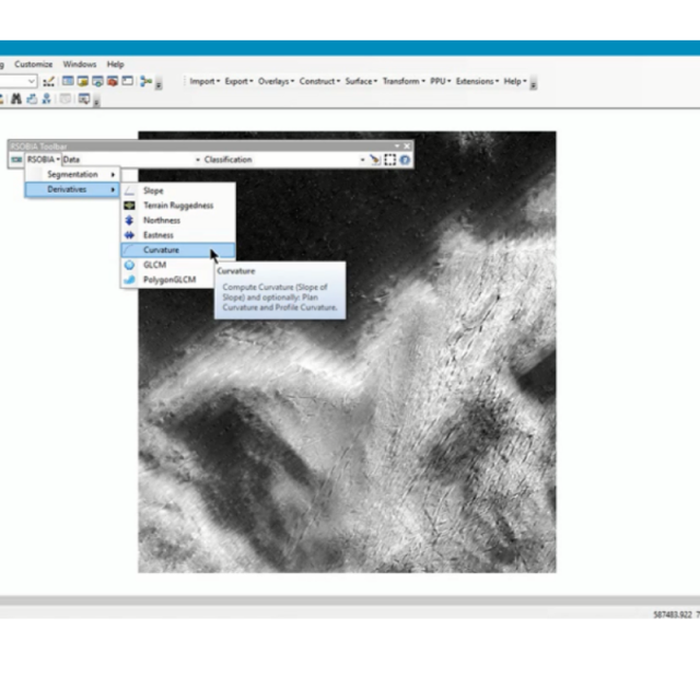
It interprets and digitises the areas and boundaries seen in imagery (such as sidescan sonar and multi-beam backscatter) and creates a polygonised map of the results (e.g. areas of similar seafloor type). It supports Segmentation and Classification which are key techniques for image analysis, and gives quick, easy, repeatable results.
Key Benefits:
- Works with all types of imagery data
- Quick (e.g. 250mb image < 40 secs)
- Divides the data into areas of similar appearance (segments)
- Can use more than 3 data layers (no limit)
- Each polygon has statistics for every image layer
- Scale and level of detail defined by numeric parameters chosen by the user – providing either a high resolution interpretation or a more generalised solution
- Repeatable and objective
- Easy to install
- Works with and compliments your existing GIS platforms
Without the tool, digitising images can be slow, subjective – dependent on the interpreter – and is non-repeatable. Using RSOBIA, segmentation of the results will provide straight-forward and objective polygons which are statistically calculated. Imagery derivative processing techniques are provided for ease of use but also include texture analysis techniques such as homogeneity, dissimilarity, contrast and others (Grey Level Co-occurrence Matrices – GLCMs). Speed of results will depend on the size of the image and speed of the computer being used.
Delivered as a part of Maritime Toolbar, RSOBIA is compatible with ESRI ArcMap 10.0 to 10.7 making it integral to your workflow. ArcGIS advanced level licence is required.
This extension has been created by OceanWise’ Licensed Partner Tim Le Bas and is maintained and supported by OceanWise as a collaborative project.
Specifications
-
Processing
-
Sound velocity correction
Sound velocity correction type
Tidal reduction
Mulitbeam Calibration mehods

