
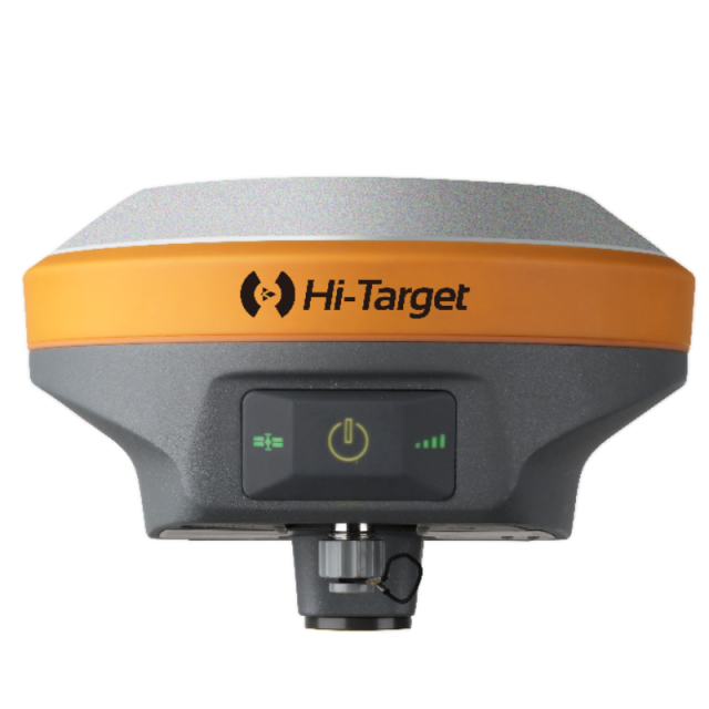
V90 Plus GNSS RTK System
Provides a high-performance GNSS measurement operation

Hi-Target
Guangzhou, CN
Description
Optional Transceiver UHF Radio
Three types of internal UHF radio provide different frequencies based on users' requirements. The SATEL internal UHF radio is compatible with other radios.
Tilt survey and Electronic bubble
Achieves corner points measurement at an inclination of up to 30°. An optimized tilt survey algorithm and procedure with the electronic bubble can boost efficient fieldwork.
Quasi-dynamic technology
Self-developed technology of the GNSS RTK system, which greatly improves surveying accuracy in harsh environments through bespoke algorithms.
For more information, please click HERE to visit our website.
Do you have questions about this product?
- Questions about price, availability, and/or retailers
- Questions about technical specifications and usage
- Questions about suitability for your project or application
Specifications
-
General
-
Year of initial introduction
2015
Height [m]
0.083
Depth [m]
0.083
Width [m]
0.153
Total Weight [kg]
0.95
Housing Material
Magnalium
Type
Land
-
Performance
-
Tracked satellite signals
GPS, GLONASS, Galileo, BDS
RTK Network Compatibility
Y
No. channels
220
SBAS differential signals
EGNOS, WAAS, MSAS, GAGAN, QZSS
Type of measurements
Surveying
-
Environment
-
Operating temperature: min. [°C]
-40
Operating temperature: max. [°C]
75
Humidity resistance
100
Water sand and dust proof
IP67
Shock and vibration proof
Designed to survive a 3m(9.84ft) natural fall onto
-
Communication: general
-
Communication ports
SD Card, USB, RS-232 /422 Serial, Compact Flash, WiFi, Radio, GSM, UMTS, Event Input
PPS Out
N
Bluetooth
Y
-
Communication: Protocols
-
RTCM standards for differential data
RTCM 2.1, 2.3, 3.0, 3.1, 3.2 input and output
CMR standards for differential data
CMR, CMR+, sCMRx input and output
NMEA output format
NMEA-0183 GSV, AVR, RMC, HDT, VGK, VHD, ROT, GGK,
L-Band Compatible
Optional
-
Communication: links
-
Radio modems
Internal UHF, External Radio
GSM; UMTS phone modems
Internal GSM
-
Horizontal uncertainty
-
code: DGNSS/RTC (constant part) [m]
0.25
code: DGNSS/RTC (variable part) [ppm]
1
phase: RTK kinematic (constant part) [m]
0.008
phase: RTK kinematic (variable part) [ppm]
1
Initialization time on the fly [s]
8
phase: RTK rapid static (constant part) [m]
0.0025
phase: RTK rapid static (variable part) [ppm]
0.5
phase: kinematic post processing (constant part) [m]
0.01
phase: kinematic post processing (variable part) [ppm]
1
RTK network solution methods
Internal GSM
-
Power
-
Typical consumption [W]
3.5
Operating time with internal power supply [hr]
12
Rechargeable with (auto)battery
Yes
Operating power: min. [V]
6
Operating power: max. [V]
28
Internal power supply
5000mAh lithium-ion rechargeable and remove battery
External power supply
6-28V DC external power input
-
More information
-
Distinguishable features
Support tilt survey, electronic bubble


