

About GeoDyn Technology
GeoDyn provides photogrammetric aerial film scanning and georeferencing services to organizations looking to transform their aerial film archives into valuable assets. Film rolls, cut films or glass plates are quickly scanned using our photogrammetric accurate PromptScan technology. Our automated georeferencing procedures and value-added services for AT and orthorectification, provide practical and efficient solutions to create temporal pixel aligned base maps. As an Esri gold network partner, we assure integration with ArcGIS for image dissemination, visualization and analysis.
Our Services
· PromptScan Photogrammetric Aerial Film Scanning
· Automated Georeferencing & Aerial Triangulation
· Orthophotos & Mosaic Generation
· Dynamic & Oriented Imagery
· 2D & 3D apps + Stereo
· Publishing to ArcGIS Online & Enterprise
· Integration into Web Portals & Apps
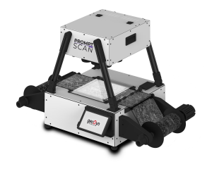
PromptScan
Is a range of photogrammetric aerial film scanners enable the digitization of aerial photographs at upto 12.5um, 50x times faster than conventional film scanners, providing rapid and affordable digital access to huge collection of archived historical aerial photography.
Featured products


GeoDyn GmbH
-
Pienzenauerstraße 58
81925 Munich
Germany -
+49 89 21758880
- https://www.geodyn.com/
GeoDyn Technology Ltd.
-
Office 623, Building 6EA, DAFZ, PO Box 371838
United Arab Emirates -
+971 4 214 6270
- https://www.geodyn.com/