
Description
Tunnel data processing
This software, working under AutoCAD,allows to process data gathered from total stations running TcpTunnel or other programs. Every project is compound of a horizontal and vertical alignment, superelevation, templates and point files, supporting different formats.
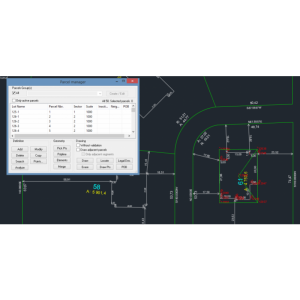
Template Definition
Templates can be defined by parameters or selecting a polyline in AutoCAD. The distances from the center of template to alignmentand superelevation criteria must be given.It is possible to apply different templates to intervals of alignment and interpolate their dimensions.
Cross section calculation and editing
The measured cross-sections can be computed from points, giving the chainageinterval, minimum number of points, undercut and overcut tolerances, etc. For generating the cross-sections, the measured points are analized regard to hozirontal alignment of the project, supporting even spirals and alignments with crossed sections.Also with the editor are included tools for removing, adding or moving points before drawing, comparing with the theoretical tunnel template.
Cross-section drawing
It is possible to draw cross-sections inCAD, in individual mode or by sheets. There are options to label differences between project and measured cross-sections as well as station, heights, areas, etc.
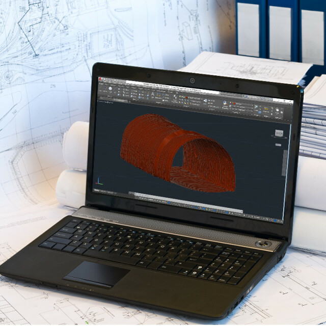
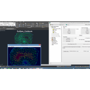
Tunnel Drawing
It is possible to create a 3D view of measured cross-sections as a wireline drawing. There are options to draw measured and project cross-sections, the alignment in 3D, longitudinal lines, etc.
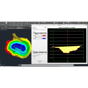
Volume Calculation
The program computes volumes of infra and over-excavation by comparing project and measured cross-sections. Reports can be generated and sent to printer, ASCII or HTML files and exported to Word or Excel. 3D Model. The program allows to generate a 3D triangulation of the tunnel, take a tour inside it and export to several file formats of geometrical definition, are as OBJ and OFF.
Specifications
-
Data management
-
Security options for access
Y
Search on file content
N
Version management
N
Save standardization for drawings/maps
Drawing layers, Styles, Settings, Symbols, User-defined objects, Others
Spatial reference system
Selectable, Fixed, Manual georeferencing
-
Geometry types
-
Points
Point, Text, Others
Lines
Line segment, Polyline, Arc, Others
Surfaces
Polygon, Circle, Multipolygon, Others
-
Other
-
License or freeware
License
Training
Y
Main users
Surveyors,construction companies
Main applications
Tunnel works control
Distinguishable features
TcpTunnel runs in motorized total stations or data collectors and TcpTunnel CAD run as a standard CAD application.Project definition based on alignment, tunnel template and points.Automatic cross section measurement.Setting out the front, cross-sections or road surface.Profile calculation and editing.Customizable drawing of cross-sections.Under and overbreak area and volume reports.
Related products
AutoCAD, BricsCAD, ZWCAD
-
2D Editing
-
Select
Spatial selection, Multiple select, Others
Remove
By select, By layer, Others
Graphic transformations
Scale, Copy, Move, Rotate, Mirror, Align, Others
Coordinate transformations
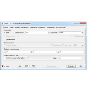
Supported Total Stations: Geodimeter: 400, 412, 600, ConstructorGeomax: Zoom 80(*)Leica: T1000, TC303, TC707, TC800, TC1000, TC1100, TM30(*), TPS1200(*), TS11(*), TS15(*), TS30(*), MS50(*)Nikon: DTMPentax: PTSII, R300, R400, V300Spectra: Focus 10Sokkia: 1130R, 3000, 3100, 3110, 3130R, 3230RM, Set3B2, SRX, SX, DX, FXTopcon: 200, 600, 750, 800, 3000, 7500, 8000, 9000, DS, IS, MS, OS, PS, QSTrimble: 3300, 5000(*) GeoCOM license required
-
2D Construction
-
Positioning by coördinates
Y
Positioning by snapping
Y
Positioning on virtual raster
N
Positioning in relation to other element
Parallel, Extend, Perpendicular, Particular angle, Tangent, Others
Positioning by Dimensions
N
-
Storage
-
Type of data storage
File
Native storage format
dwg
Input formats
Dwg, Dxf, Others
Export formats
Dxf, Others
GML version
None
Compression
N
-
Visualisation
-
Types
Color, Pattern, Hatch, Gradient color
Change view
Zoomfactor, Target point
-
Data analysis
-
Merge
Map layers
Clip
Y
Measurement
Area, Length, Others
Topology
Build, Check, Clean
Tools to detect errors
N
-
Interoperability
-
Web standards
None
Spatial database management systems
None
Messaging protocols
None
Publish standards
None
Extensions
none
Available API’s
None
-
General
-
Year of introduction
2005
Year of last update
2019
Supported hardware
Mobile devices with ARM processor and Microsoft Pocket PC 2003, Windows Mobile 5.x/6.x or - Windows 7, 8, 8.1 and 10 (32 and 64 bits) operating systems.
Supported operation system
Windows


