Overcome the Barriers of Creating Reality 3D Models Using Point Cloud Software
Last month I was really pleased to present at the Festival of BIM and Digital Construction alongside Dennis Dixon, Senior BIM Manager at WZMH Architects; Michael James, Director of Building Construction Solutions for Leica Geosystems; and Will Tompkinson, Manager of North America for PointFuse. Our panel discussion focused on three obstacles that lots of construction organizations face when embracing reality capture to supercharge their digital construction efforts.
It was a really interesting conversation, even to someone immersed in the industry like me. Hearing Dennis, Michael and Will talk about the potential for reality capture to bridge the gap between as-built conditions on the ground and the world of digital design, was really exciting. In this blog, I want to share the outcome of that discussion, and how you can integrate reality capture into your digital construction and established on-site workflows.
The First Barrier:
''Scanning is Complex''
There’s long been a perception in the industry that scanning is a complex undertaking, requiring a lot of time, effort and expertise to get right. The panel’s discussion revealed that the truth in 2020 is quite different.
Since the early days of scanning tech, manufacturers have been focusing a lot on simplifying scanner technology, and today you can find compact, easy to use, and even hand-held scanners. These lessen challenges like site access for scanning teams, ideal in a post-COVID world where the movement of people on site is critical. And their simplicity makes them ideal for getting as-built data or conditions quickly with the minimum of disruption. Progress monitoring of a build or capturing up to date floor space and utilization were a few of the many examples discussed.

It is true that if you’re scanning a complex site, or you need a really high level of fidelity, the job can still be relatively complex. In this situation, the panel pointed out that one option is to work with a service provider who can do the scanning for you. There are plenty out there in the market to work with, and their expertise means you can rest assured that you’ll get usable, and therefore valuable, data for your digital construction workflows. If you’re doing it yourself, the panel recommended remembering the basics. It’s important to make sure you have scan targets set up correctly so you can accurately align and register multiple scans of a building, for example.
Most important, whether you do the scans yourself or get a third party to help, it’s vital to understand what the data is needed for and how it will fit into your workflow. For instance, if you’re scanning a building so that you can identify pipework, there’s no point in gathering data on the outside of the building. Planning your scanning in advance and only capturing what you need for the project you’re working on, will help you deliver real ROI on projects as you save time and provide richer information. Which leads us nicely on to barrier 2…
The Second Barrier:
''Point Clouds are Cumbersome''
Dennis told the panel that when it comes to point clouds, storage and collaboration are the greatest challenges organizations face. Point clouds often take up hundreds of gigabytes of storage space, while modern computers perhaps have 250GB of memory as standard– meaning that computers often need to be custom-built to accommodate these massive files.
The panel discussed a few solutions to this problem. One, as we’ve already discussed, is to only capture what you need when scanning, reducing the amount of unnecessary data in the point cloud. Another is to invest in cloud technologies to store and share large files, which means you don’t need to spend lots of money on high-performance computers just to store and read point clouds. Michael pointed out that this solution is becoming more viable now that 5G networks are becoming more prevalent, enabling masses of data to be shared and stored in the cloud.

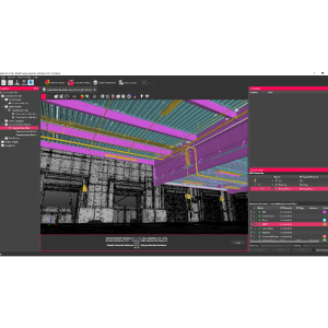
Another solution the panel discussed which is perhaps most exciting is to investigate software that automatically generates mesh models from your point cloud. Mesh models are generally much smaller than point clouds and are traditionally used to visualize designs. But working with software like PointFuse, you can create mesh models that can be used for all the work that point clouds are traditionally used for while being up to one-hundredth of the size. This not only makes it much easier to store and share the data from your scans with your colleagues, clients, and other stakeholders, it also makes it much easier for them to work with that data to get their jobs done.
The Third Barrier:
''Providing As-built Information to the Right People, at the Right Time is Difficult''
We all know that sometimes changes have to be made to the original plans for a project, and the impact those changes can have on subsequent project phases, project signoff, or even the fulfilment of contractual obligations on a project. That’s why it’s essential to provide as-built information as the project progresses. But point clouds, as we’ve already discussed, can be so big that sharing them with others is impractical. And even if you can share them, their size, and the level of information in them, can make them very difficult for other stakeholders to use effectively. For example, if a team is looking at clash detection between structural and MEP, it can be laborious and confusing to interpret the point cloud and compare it with the design to identify potential clashes.

The panel was quick to point out the benefits of working to a process here. If you’ve captured specific information at the scanning stage, then you’ll have less irrelevant data to sift through. And if your process includes a step for classifying the data you’ve scanned and disseminating that information to the right people, their jobs will be completed faster and more accurately. It’s another reason to use mesh models instead of point clouds, their malleability makes them much easier to share with multiple parties, and to work on digitally. The key, as the panel discussed, is the classification of the elements in the point cloud to create ‘intelligent meshes’ that show specific data such as MEP, windows, or structural members. Intelligent meshes enable you to quickly share relevant data with the right people, without dealing with large file sizes, which, combined with the right scanning tools, gives you the flexibility to generate new scans every week, knowing that you’ll always be able to handle the data quickly and efficiently. Will pointed out in the discussion that this could help you reduce rework costs from as much as 20% to as little as 1%, something that I’m sure will be hugely welcome to everyone in these cost-sensitive times.
PointFuse:
Intuitive software to easily manage point clouds and make digital construction happen in your organization
We hope this blog has given you some food for thought if you’ve previously dismissed reality capture as too difficult to implement in your organization. The truth is that there’s no one switch you can flick to make it all work for you, but at the same time, it’s not as hard as people believe.
The key, as we’ve learned, is to gather the right data, classify it, and share it with stakeholders and decision-makers quickly and easily. So you might be interested to know that PointFuse helps automates a lot of this process for you. By categorizing point cloud data and filtering out irrelevant data, PointFuse helps you quickly create meshes that can be up to one hundredth the size of a point cloud, removing the need for expensive IT systems, or for painstaking work to manually identify and classify elements in your point cloud. Best of all, it’s incredibly intuitive, meaning your team doesn’t have to spend hours learning how to use the software before you see a return on your investment.
You can import almost any kind of point cloud file into PointFuse, and generate meshes that can be used by a wide variety of different BIM workflows and tools. So whether you’re importing scans you’ve made yourself, ones generated by a partner, or both, you can get all your data in one place, easily accessible by those who need it, to help projects run smoother and faster.
If you’d like to see how PointFuse can help overcome the barriers to digital construction presented by point clouds, why not arrange a demo with PointFuse? We can work with one of your existing point clouds, if you have one, to show you how simple it is to turn that data into usable, intelligent mesh models that you can insert straight into your BIM workflows.

Related products


![3月21日-封面[1].jpg](https://cdn.geo-matching.com/voeE1ywo.jpg?w=320&s=6b3b1a0215d770f8797653e9202a8f52)


