From Point Cloud to 3D Model in a Third of the Time
The Mississauga, Ontario office of a global multidisciplinary engineering firm, Hatch, was commissioned by the facility management team of an aluminium casting plant to consult on health and safety matters related to the built structure and layout of the plant. This included conducting flow studies of both goods and materials for emergency planning purposes. Being a multi-level, mixed-use facility comprising both hazardous industrial processes and office space, an accurate as-built baseline needed to be captured first. Due to the intricacies in the layout and structures in the plant Hatch subcontracted a full 3D laser scan of the facility to provide the highest resolution 3D data at the beginning of the project, and to form the basis of subsequent modelling.
Main Challenge, Point Cloud Management
Point clouds provide high-resolution, three-dimensional, measurable detail of a site. Yet, these data sets can bring high storage costs, and the point cloud usually needs to be digitized to convert the real-world information seen in the point cloud into compliant data models for use in downstream virtual design and construction, or engineering software. This conversion into a compliant data model takes project time and cost.
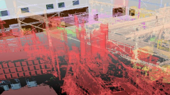
Since this plant lacked previous as-built drawings, Hatch had been very thorough in the specifications outlining how the laser scan data was to be collected. The scans had been captured to ensure that someone interpreting the point cloud could virtually walk through the plant seeing every corner with the minimum of blind spots. The compromise with this approach is that more scan positions are required, and higher volumes of data need to be managed.
After receiving the point cloud data from their vendor, the Hatch team set about isolating envelope geometries (walls, floors, and ceilings) through the facility to draft into CAD data. John Hemingway, Senior Project Manager at Hatch recalled:
“We were able to produce a rough sketch that was incomplete but was a start on the floor plans. We realized that this approach was going to be too labour intensive and we had continuing issues with the size of the raw cloud data causing our computers to be slow and crash frequently. After two members of the team spent around 9 days manipulating the raw point cloud data a rough sketch of the site was produced but being able to produce as-built data of the site suitable to run simulations and make tangible project decisions was still some way off.”

The Solution? Convert Point Cloud into Classified Mesh Models!
The team at Hatch realized that they needed to innovate their approach to completing this project. The point cloud data collected for Hatch needed to be both reduced in size and modelled intelligently for use in subsequent engineering and analysis workflows, all without significantly increasing the project’s budget. Upon the recommendation of their scanning contractor, Hatch invested in PointFuse.
PointFuse software implements a unique meshing process that automatically converts the point cloud into an intelligent, structured 3D mesh data model. Each real-world object seen in a PointFuse mesh can be selected, isolated, and classified. Without needing to manually digitize the point cloud, using PointFuse Hatch could build-up a classified 3D model of the site that is compatible with the rest of the design, engineering and visualization software that they were using downstream on the project.

Intelligent Classified As-built Mesh Generation
Hatch first used PointFuse to classify the point cloud of the facility into classification layers that included the envelope structure of the building, but also other obstacles are seen in the facility ranging from permanent structures such as roof beams and furnaces, through to more transient elements such as stockpiles of input and output materials. This step reduced the size of the functional dataset by around 30% of the size of the original point clouds, meaning the outputs could be easily shared across multiple team members simultaneously. These classified models were then exported directly into the 3D coordination software used by the team so that decisions could be made about the next steps in the project.
Using PointFuse Space Creator to Produce BIM Geometry
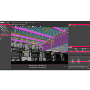
The key deliverables from the first phase of this project was a floorplan of the facility. To produce the floorplan, the classified PointFuse as-built mesh was then passed through the next stage of the PointFuse workflow; known as PointFuse Space Creator. Designed as a ‘single-button’, automatic process for facility managers and space measurement professionals to easily produce simple, parameterized BIM geometry of their facility, PointFuse Space Creator converts selected classes from the as-built mesh into full parameterized IFC BIM object elements.

Parametric IFC BIM geometry of the multistory office room at the aluminium casting plant, suitable for export directly into Revit
Prior to export, quality assurance was performed in both 2D and 3D using PointFuse Space Creator’s own CAD tools to easily edit the models. The BIM geometry was then exported directly into Autodesk Revit, where PointFuse’s BIM geometry was automatically converted into Revit family elements; and Bentley Microstation. In this project, the parametric BIM model of the aluminium casting plant was exported and presented to the client at the aluminium casting plant as a multi-level floorplan in CAD. This was the first time that a comprehensive floorplan of their site had been produced since its construction in 1973.

Hybrid-view showing deliverables from this project: As-built mesh and parameterized BIM model in the same view (main), and 2D floor plan geometry (inset)
Aluminum Casting Plant Model in Further Development
PointFuse presented a workshop that showed Hatch how to use the existing tools within PointFuse to further optimize the mesh model to identify and classify the location of emergency fixtures such fire extinguishers, eyewash stations and emergency exits. Hatch’s technical staff were then able to continue their project by isolating the geometries of these specific elements in the as-built mesh model. The emergency fixtures were exported for use in 3D coordination environments to formulate emergency plans; geometries of specific beams and supports were exported to assist structural engineering work.
Return on Investment (ROI)
Within two project days, PointFuse was used to convert the point cloud into a classified mesh data product, from which envelope geometry was then converted using PointFuse SpaceCreator into a parametric BIM model of the facility using a simple 3 step process. From a Professional Services delivery perspective, project success is often measured by the extent that to which timelines exceed the budget.
Within this project, excess project time had been spent unsuccessfully trying to prepare point cloud data collected for the project into formats that could be easier to interpret by technical and engineering staff. Hatch needed a solution that would enable the project to deliver to their client with a minimum overrun of budget.
“Had PointFuse been implemented at the very start of the project, the project time savings would have been significant, even as much as 50-60 hours (approx. 7 days) of technical time plus some engineering time?” said John Hemingway, Senior Project Manager, Infrastructure, Hatch
“Using PointFuse reduced data preparation time to just a total of 2 technical project days'' - John Hemingway, Senior Project Manager, Infrastructure, Hatch
While it may have been frustrating for Hatch’s team to find a solution midway through the project that could have saved approximately 70% of the project budget assigned to point cloud processing, the extra project time required to run this phase of the project was relatively minimal.
John Hemmingway continued: “Using PointFuse reduced data preparation time to just a total of 2 technical project days. This meant that the Hatch team could deliver their project on time and with minimal budget overrun following the issues encountered when processing the point cloud using traditional methods.”
Finally, in addition to keeping to project timelines, the Hatch team were able to move their focus to provide their expertise to the project that required the as-built data in the first place. As evidenced by providing 3D deliverables as opposed to traditional 2D CAD floorplans, using PointFuse gave Hatch the capacity to concentrate on delivering additional value to their client.
With the benefit of hindsight, implementing PointFuse at the beginning of this project could have saved about a week of project time for Hatch’s team. What this project shows is that innovative technologies such as PointFuse provide the opportunity to minimize future project and cost overruns and help professional service firms keep delivering projects efficiently.

Related products


![3月21日-封面[1].jpg](https://cdn.geo-matching.com/voeE1ywo.jpg?w=320&s=6b3b1a0215d770f8797653e9202a8f52)


