
WorldView-3
The Power of 30 cm
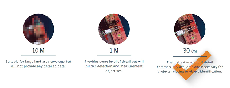
The power of 30cm Very High Resolution (VHR) satellite imagery lies in its ability to detect small objects. It allows you to achieve a level accuracy that’s necessary in order for your project to succeed. Through the use of Maxar's WorldView-3 satellite and our ground control station near Munich, Germany, we are able to proficiently ollect and deliver 30 cm and other VHR imagery to you.
Description
WorldView-3 was launched on August 13 2014, and truly set a new standard for commercial satellites in-orbit. With 29 spectral sensors on-board, the data from WorldView-3 allows you to differentiate between objects with far greater accuracy. Additionally, WorldView-3 was the first satellite capable of delivering true 31 cm resolution and it collects the industry’s best very high resolution imagery quickly and reliably.
Specifications
-
General
-
Year of introduction
2014
Deliverable raster products
Raw Imagery, Orthorectified imagery
Options for delivery
FTP
Satellites or constellations of delivered products
WorldView-3
Deliverable vector products [2D and 3D]
aircraft or satellite
Continents
-
Image corrections
-
Proces of geometric correction
Ortho-Rectification, Atmospheric Compensation
Image sharpening methods
Pan-Sharpening
Sensor corrected
Y
-
Imagery Specifications
-
Spectral band types
Red, Green, Blue, Red edge, Near-infrared, SWIR
Spectral bands [specify wavelengths]
8 Multispectral Bands ranging from 400 - 1010 nm, 12 SWIR Bands ranging from 1195 - 2365 nm, 12 CAVIS Bands ranging from 405 - 2245 nm
Dynamic range of RGB image [bit depth]
16
Data formats of imagery
GeoTIFF, JPEG, NITF, RAW
-
Revisit time and delivery
-
Revisit time for defined data products
Less than 1 day
Delivery time [Time between data capture and delivery; in hours]
1
-
Resolution and Accuracy
-
Resolution of RGB imagery [best GSD in centimeters]
100
Geolocation accuracy [RMSE at nadir in centimeters]
200
Geolocation accuracy [CE90 at nadir in centimeters]
300
