Trimble RealWorks
Trimble Realworks Is Specifically Designed for Point Cloud Processing and Analysis
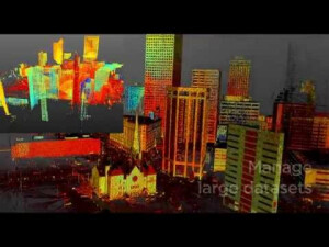
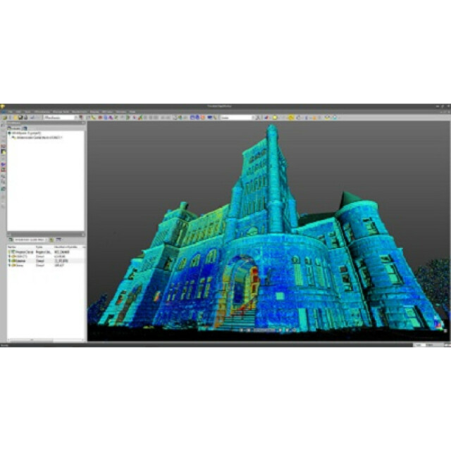
The software provides a complete solution to efficiently register, analyze, model and create deliverables using data from virtually any source.

Trimble, Inc.
Westminster, US
Description
Trimble RealWorks is specifically designed for point cloud processing and analysis. The software provides a complete solution to efficiently register, analyze, model and create deliverables using data from virtually any source.
Do you have questions about this product?
- Questions about price, availability, and/or retailers
- Questions about technical specifications and usage
- Questions about suitability for your project or application
Specifications
-
Hardware/software requirements
-
RAM [GB]
8
HD [GB]
256
Use of GPU
Y
Processor
["64-bit"]
Stereo Display
N
-
Other
-
Support
Yes
Training
Y
Typical applications
Oil&Gas, Facilities, BIM, Civil and Architecture,
Distinguishing features
Fully automated tools for registration and matching of panoramic images. Powerful measurement and analysis tools for quickly calculating volumes, clearances and comparing point clouds over time or to models and surfacesAdvanced Tank edition for storage tank inspection, calibration, secondary containment analysis and reporting.
-
Files and Registering
-
Input formats
ASCII, LAS, e57, fls, zfs, rsp, ptx, pts, dp, fbx,
Output formats
ASCII, dfx, dwg, pod, pts, fbx, dgn, e57, LAS, LAZ
Geo-referencing
Y
Automatic Target Detection
Y
Stitching multiple scans
Y
-
Pre-processing and Automatic Filtering
-
Image matching facilities
Y
Removal of individual outliers
Y
Removal of vegetation
Y
Removal of buildings
Y
Bare ground DEM generation
Y
-
Manual Measurements
-
3D Coordinates extraction
Y
Length and Height
Y
Angle
Y
Distance
Y
Area
Y
Volume
Y
-
Interoperability
-
CAD software
SketchUp, AutoCAD, Microstation
Assigning colour from imagery to points
Y
Image overlay on TIN
Y
-
General
-
Year of last update
2015
Year of initial introduction
1994
Modules
Trimble RealWorks BaseTrimble RealWorks AdvancedTrimble RealWorks Advanced-ModelerTrimble RealWorks Advanced-Plant moduleTrimble RealWorks Advanced TankTrimble Realworks Viewer Utilitiy
Source of Point Clouds
Airborne Lidar, Indoor TLS, Outdoor TLS, Photogrammetric
Supported Systems
Virtually any point cloud source. See supported import formats.
-
Analysis
-
Line of sight
N
Aspect and slope
Y
Individual tree heights
Y
Time series analysis
Y
-
Automatically Generated Products
-
Regular Grid DEMs
Y
Cross sections
Y
TIN
Y
Contour Lines
Y
Break lines
Y
Boundary detection of solids
N
Building footprints
N
Building roofs
N
-
Solid Modelling
-
Lines
Y
Planes
Y
Cubes
Y
Spheres
Y
Cylinders
Y
NURBS
N
-
Visualisation and Editing
-
Zoom, pan and rotate
Y
Fly-throughs
Y
Adding Points
Y
Removing Points
Y
Point Reduction
Y
Documents
Brochure
migrationkayevg.pdf
970.41 KB
Videos


