
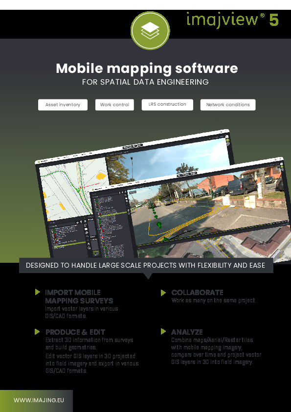
imajview® 5
Multisensor mobile mapping software
By leveraging the capabilities of imajview 5, you can seamlessly visualize, process and consume any georeferenced survey made with flat or panoramic imagery, from various mobile mapping vendors or action cam vendor. From such survey you can postion in 3D, measure in 3D, produce or edit feature layers in spatial DB, or import vector layers from a wide spectrum of GIS/CAD formats.

imajing
Labège, FR
Description
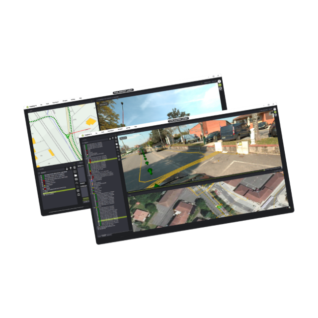
MAPPING SURVEYS
Mapping Surveys take center stage, allowing you to transform imported data into rich, detailed visualizations. With an array of survey tools at your disposal, you can create comprehensive inventories or maps that serve as the foundation for your projects.
COLLABORATE
Collaboration lies at the heart of our platform. Multiple minds can converge on a single project, fostering creativity and enhancing productivity. Whether you're working in the same room or across continents, our collaborative tools ensure that every team member's contributions are seamlessly integrated.
PRODUCE & EDIT
Time to dive deeper! Extract 3D information from your surveys and craft intricate geometries that breathe life into your data. Thanks to our 3D projection capabilities, you can edit vector GIS layers while overlaying them onto field imagery. Once perfected, export your work in a variety of GIS/CAD formats, ensuring compatibility and accessibility.
ANALYZE
Now comes the analytical powerhouse. Combine maps, aerial imagery, and raster tiles with the mobile mapping data you've captured. Analyse changes over time and project your vector GIS layers into the three-dimensional realm of field imagery. This integrated approach grants you a panoramic view of your data, illuminating insights that were previously hidden.
Do you have questions about this product?
- Questions about price, availability, and/or retailers
- Questions about technical specifications and usage
- Questions about suitability for your project or application
Specifications
-
Feature Extraction and Mapping
-
3D superimposition
Y
Integration with 3D vector maps
Y
Integration with 2D vector maps
Y
Mapping facilities
Y
Semi-automatic line feature extraction
Y
Integration with scanned maps
Y
-
Required Computer System
-
64-bit version of software available
Y
CPU (preferred)
core i7
CPU (min.)
core i5
Distributed processing capacity
N
GPU based calculations
Y
Min. data storage capacity [Gb]
100
Min. RAM memory [Mb]
8000
Operating system(s)
windows 10,11
System includes hardware
N
-
Images and data
-
Export data formats
csv, kml, Shapfile, geopackage
Input image formats
jpg, avi
Source data
MMS (imajing, trimble, topcon,..)
-
General
-
Regional settings available
EN, FR, SP
Year of introduction
2023
Year of last update
2024
-
Measurement tools
-
Area
Y
Length
Y
Volume
N
-
More information
-
Distinguishable features
linear referencing system management
Main applications
terrestrial mobile mapping processing
Documents
Brochure
imajview5_EN.pdf
1.73 MB


