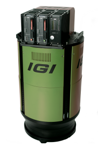
IGI UrbanMapper-2P
2-IN-1 Large Format & Oblique Aerial Camera System
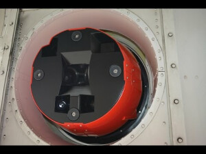
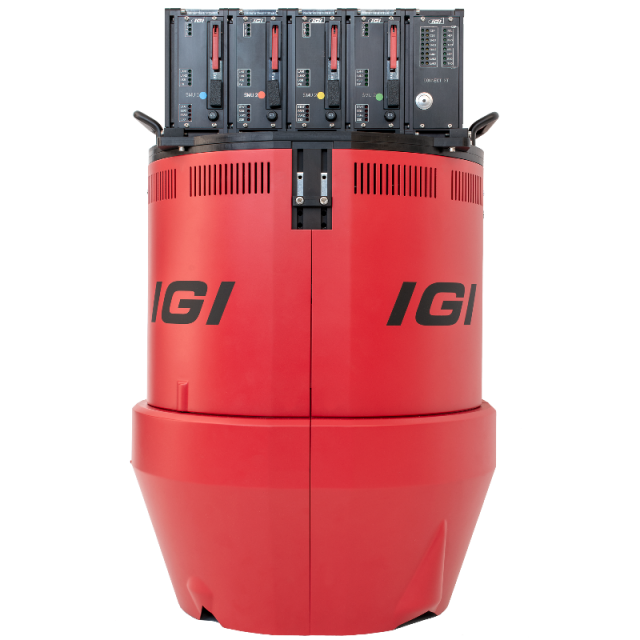
The IGI UrbanMapper is a large format digital aerial camera. Simultaneously it is also an oblique aerial camera system, providing four views to all sides. It is the next generation of digital aerial camera systems for the production of large-format nadir and oblique aerial imagery within one single flight.

IGI
Kreuztal, DE
Description
Based on the IGI UrbanMapper, IGI introduces the IGI UrbanMapper-2P. The IGI UrbanMapper-2P uses the latest Back Side Illuminated - BSI-CMOS technology, so it delivers brilliant images even in difficult lighting conditions. With an RGBI resolution of 34,500 x 14,100 pixels, it outshines other systems and offers the best performance in its class.
Do you have questions about this product?
- Questions about price, availability, and/or retailers
- Questions about technical specifications and usage
- Questions about suitability for your project or application
Specifications
-
Application
-
Training facilities
Yes
Main applications
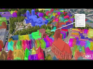
Digital Twin, 3D City Modelling; Oblique & Nadir Photogrammetry; Remote Sensing; Digital Mapping
Distinguishable features
2-IN-1 Large Format + Oblique
-
Uncertainty
-
Precision [pixels]
0.2
Geometric calibration
Y
Radiometric calibration
Y
-
Data storage
-
Type of storage
SSD
Storage capacity [GB]
Up to 16TB Storage Units (with RAID Option)
Storage Replaceable
Y
-
Sensor Characteristics
-
Number of lenses
8
Lenses: focal lengths [mm]
90, 150, 180
Lenses: interchangeable
Y
Type CCD
BSI-CMOS
Pixel size [µm]
3.76
Megapixels
Nadir 480 MP & Oblique 150MP
CCD RGB
Y
Charged Coupled Device (CCD) IR
Y
CCD simultaneous
Y
CCD along track format [mm x mm]
52.9
CCD along track format [pixel x pixel]
14.100
CCD across track format [mm x mm]
129.72
CCD across track format [pixel x pixel]
34.500
Max. shutter speed [s]
1/2000
Data collection rate [megapixel/s]
2000
Max. across-track FOV [deg]
73
Dynamic range [bits]
16
Type CMOS
BSI-CMOS
-
Operation Characteristics
-
Helicopter
N
Fixed-wing
Y
Max. acquisition duration [h]
No limitation
In flight pre-view
Y
Temperature controlled pod
Y
Forward motion compensation
Y
Warm-up time [s]
90
Platform
Fixed-wing
Min. flying height [m]
400
Typical flying height [m]
1200
Max flying height[m]
6000
Max. acquisition time [hr]
12
-
Software
-
On board image storage format(s)
RAW
Type of mission planning software
IGIplan
Type of postprocessing software
IGI AEROoffice, IGI IPS( Image Processing Software)
-
General
-
Year of introduction
2018
-
Hardware
-
Camera unit Weight [kg]
51
Camera unit Length [m]
0.813
Camera unit Width [m]
0.402
Camera unit Depth [m]
0.430
Power requirements
488 W @ 28 VDC
Type of GNSS/ INS positioning system
Integrated GNSS/IMU System (AEROcontrol)
-
Application areas
-
Select an application area:
Construction and Infrastructure, Cultural Heritage, Land Surveying and Cadastre, Oceanography, Offshore Renewables, Oil and Gas, Defense and Security
-
Product characteristics
-
Choose characteristics:
Oblique, Nadir, High-altitude, Gyro-stabilization
Documents
Brochure
15-igi-2018-10-igi-urbanmapper-2-a4-portrait-4s-en-web.pdf
1.46 MB


