
Hydrins
Navigation-Grade INS for hydrographic survey
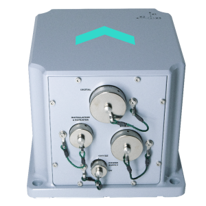
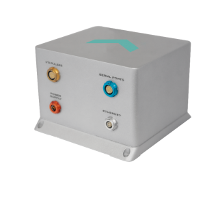
Hydrins is a high-performance Inertial Navigation System (INS) based on Exail Fiber-Optic Gyroscope (FOG) technology, electronics, and embedded processing. Compact and lightweight, it delivers highly accurate real-time position, heading, attitude and speed data, for direct georeferencing.

Exail
Saint Germain en Laye, FR
Description
Hydrins is a high-performance Inertial Navigation System (INS) based on Exail Fiber-Optic Gyroscope (FOG) technology, electronics, and embedded processing. Compact and lightweight, it delivers highly accurate real-time position, heading, attitude and speed data, for direct georeferencing.
Features & Benefits
- High-accuracy 3D positioning with heading, roll and pitch.
- Compact, lightweight, and reliable.
- Benefiting from FOG (Fiber-Optic Gyroscope) unique strap-down technology.
- Compatible with all GNSS receivers.
- Simplified Integration with a single GNSS antenna setup.
- Automatic GNSS drop-out / multipath management.
- Realtime heave and delayed Smart Heave™.
- Permanent quality data thanks to Exail Delph INS post-processing software
- Ethernet, web server (GUI).
- Fast alignment (no aiding sensor).
- IMU option for high accuracy platform stabilization.
- Low latency for real time control loops.
- Static and dynamic alignment modes, with and without GNSS.
- 4Gb embedded data logger.
- Versatile I/O options for an easy integration.
- Maintenance-free.
- ITAR-free.
- 24/7 worldwide technical assistance
Applications
- Port and harbour maintenance.
- Seafloor characterization.
- Bathymetric survey.
- Platform stabilization.
- Offshore construction engineering
Do you have questions about this product?
- Questions about price, availability, and/or retailers
- Questions about technical specifications and usage
- Questions about suitability for your project or application
Specifications
-
Other specifications
-
Distinguishable features
Reliable and accurate motion, speed, position and heave data- Fast and reliable installation on all vessels- A complete solution packed with easy-to-use yet powerful post-processing tools- Motion and heading not affected by GPS outages, position remains valid for minutes- Network ready, intuitive user interface
Export restrictions
Dual use
Graphical user interface
Y
Typical application
Port and harbour maintenance, Seafloor characterization, Bathymetric survey, Platform stabilization, Offshore construction engineering
-
Environmental
-
Max. rotation speed [deg/s]
750
Operating shock tolerance [g]
27
Min. operating temperature [°C]
-20
Max. operating temperature [°C]
55
-
Software
-
Integrity monitoring of position input
Y
Integrity monitoring of log input
Y
Name
Optional post-processing software: APPS / Delph INS
Filtering
Y
Adaptable input signals
Y
Max. number of position input signals
2
Max. number of log input signals
2
Uncertainty indicators given in output
Y
Uncertainty of time stamp for output [ms]
0.1
-
GNSS aided uncertainty
-
Heading [deg]
0.01
Heave: constant part [m]
0.02
Heave: variable part [%]
2.5
Increase in position uncertainty w.r.t. stand-alone GPS [m]
0.8
Pitch [deg]
0.01
Roll [deg]
0.01
-
General
-
Year of initial development
2002
Height [m]
0.162
Width [m]
0.18
Length [m]
0.18
Weight [kg]
5.5
Power consumption [W]
21
Splashproof casting
Y
Water resistant casting
N
Mean time between failures [hr]
150000
Type of accelerometer
Pendulum
Type of gyro
Fiber Optic Gyroscope
Removable from base plate
Y
Type of application
Marine
Height [mm]
162
Width [mm]
180
Length [mm]
180
Min. Voltage (DC)
20
Max. Voltage (DC)
32
Moving parts
N
-
GNSS Positioning Sensor
-
Number of integrated GNSS receivers and antenna ports
0
-
Unaided uncertainty
-
Pitch [deg]
0.01
Roll [deg]
0.01
Heave [m]
0.05
Decrease in position accuracy [m/hr]
1111
Heading [deg]
0.05
-
Data formats
-
Other
ASCII; BINARY
NMEA formats
NMEA0183, ASCII, BINARY


