

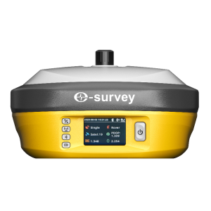
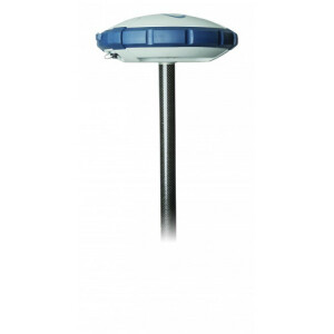
eSurvey E500 GNSS Receiver
Portable Tilt-Featured RTK Receiver
E500 is a lightweight tilt-featured GNSS receiver by eSurvey GNSS. The durable IP67 design makes it possible to work in a variety of environments. Multi constellation and frequency tracking always give a Fixed solution for your job. Thanks to the small-size design, the E500 is suitable for different applications such as car and machine control.
eSurvey GNSS
Shanghai, CN
Description
-
Multi-constellation and Multi-frequency
With 800 channels of GNSS tracking, E500 provides stable and reliable accuracy. All GNSS signals are coming with the standard including GPS, BDS, GLONASS, GALILEO, QZSS, IRNSS and SBAS.
-
Intelligent Battery LED Indicators
Without powering on the device, it is able to check the battery level on the battery LED indicators by simply clicking the power button.
-
MEMS Dynamic Tilt Survey
eSurvey’s innovative tilt survey solution provides a surprising experience. The sensor is adapted to various of working environments and can be ready within 10 sec. Maximum 60° incline angle ensures a tilt-to-go survey without stopping your work.
-
L-band Atlas
Atlas is a service to provide global precision correction service over L-band satellites. With ATLAS subscription, E500 is able to achieve centimetre accuracy without any base station.
-
RTK
Powered by Atlas, the innovative aRTK technology operates on any Atlas-capable device by enabling it to maintain RTK-level accuracy, availability, and reliability when RTK corrections fail without additional cost.
-
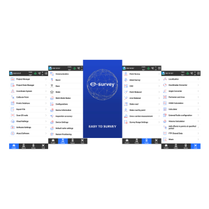
Web UI
It is able to view position status, set up working mode, download data and update firmware from the Web user interface with any phone, tablet or PC.
-
Intelligent Voice
E500 will broadcast voice automatically to remind the user the solution status is changed. It is also able to manually broadcast the current working mode and solution status by short pressing the power button.
-
Rugged Design
E500 main body is using magnesium materials to provide strong shock and vibration-resistant characteristics. IP67 certification ensures operation in various of tough environments.
Specifications
-
More information
-
Distinguishable features
IMU
-
Power
-
Operating time with internal power supply [hr]
12
Certifications
CF, FCC, NGS Calibration
Rechargeable with (auto)battery
Yes
Connectors
USB Type-C
Direct car connection cable available
Yes
Internal power supply
4800mAh
External power supply
5-pin lemo, 9~28 VDC
-
Performance
-
No. channels
800
Tracked satellite signals
GPS, Glonass, Beidou, Galileo, QZSS, SBAS, L-band, IRNSS
SBAS differential signals
Support
RTK Network Compatibility
Full compatible
Reacqisition time [s]
<10
MRS functionality
Support
-
General
-
Type
Land
Year of initial introduction
2021
Total Weight [kg]
1.06
Height [m]
0.0745
Depth [m]
0.148
Width [m]
0.148
Housing Material
Magnesium Alloy
-
Horizontal uncertainty
-
code: DGNSS/RTC (constant part) [m]
0.25
phase: RTK rapid static (constant part) [m]
0.0025
phase: RTK rapid static (variable part) [ppm]
0.1
phase: RTK kinematic (constant part) [m]
0.008
phase: RTK kinematic (variable part) [ppm]
1
phase: static post processing (constant part) [m]
0.002
phase: static post processing (variable part) [ppm]
0.1
-
Communication: Protocols
-
L-Band Compatible
Atlas H10/30/Basic
RTCM standards for differential data
RTCM2, RTCM3, RTCM32
CMR standards for differential data
CMR, CMR+
NMEA output format
NMEA0183
other output formats
Binary
Other formats for differential data
ROX
Configuration method
Web UI, Field Software
-
Recording
-
Data capacity [MB]
8192
Memory medium
Internal Storage
Type of data (on board recording)
Dat binary, Rinex
-
Communication: general
-
Bluetooth
Y
Communication ports
USB Type-C, 5-pin Lemo, TNC, SIM card
Simultaneous links
Y
PPS Out
N
-
Environment
-
Operating temperature: min. [°C]
-40
Operating temperature: max. [°C]
65
Humidity resistance
100%
Water sand and dust proof
YES
Shock and vibration proof
2m drop on concrete floor
-
Communication: links
-
Radio modems
1 watt, TX and RX, 410 ~ 470 MHz, 902.4 ~ 928 MHz
GSM; UMTS phone modems
2G/3G/4G


