NaviModel
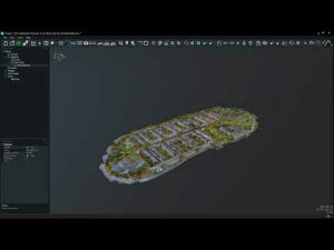
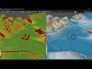
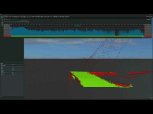
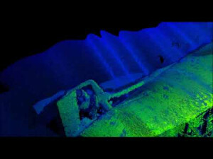
NaviModel is EIVA's NaviSuite product dedicated to 3D/4D modeling and visualization of subsea and above-water sensor data in 2D, 3D, and 4D (comparison over time). Features include point cloud stitching, generation of point clouds from XYZ or any other supported data, automatic cleaning, and the possibility of working with unlimited model sizes, just to mention a few.

EIVA
Skanderborg, DK
Description
NaviModel is EIVA's NaviSuite product dedicated to 3D/4D modelling and visualisation of subsea and above-water sensor data in 2D, 3D and 4D (comparison over time). Features include point cloud stitching, generation of point clouds from XYZ or any other supported data, automatic cleaning, and the possibility of working with unlimited model sizes, just to mention a few. NaviModel comes in three variants: NaviModel Free Viewer, NaviModel Analyser and NaviModel Producer, allowing you to choose the variant that fits your needs and budget best. Learn more at eiva.com/navimodel.
Do you have questions about this product?
- Questions about price, availability, and/or retailers
- Questions about technical specifications and usage
- Questions about suitability for your project or application
Specifications
-
Hardware/software requirements
-
RAM [GB]
8
HD [GB]
5
Use of GPU
Y
Stereo Display
Y
List software environment, e.g. Microstation
Windows 7 or 10 Pro
Processor
[]
-
Other
-
Support
24/7 email and phone
Typical applications
Subsea construction
Distinguishing features
High performance point clouds of unlimited size.High performance noise removal in sonar and laser/LiDAR data.Point cloud stitching/registration.Integrated inspection tools with live video and eventing package.
Training
Y
-
Files and Registering
-
Input formats
Many, including XYZ, LAS and LAZ
Output formats
Many, including customer-defined outputs/exports
Geo-referencing
Y
Automatic Target Detection
Y
Stitching multiple scans
Y
-
Pre-processing and Automatic Filtering
-
Image matching facilities
N
Frequency domain decoding for data reduction
Intensity
Removal of individual outliers
Y
Removal of vegetation
N
Removal of buildings
N
Bare ground DEM generation
Y
-
Manual Measurements
-
3D Coordinates extraction
Y
Length and Height
Y
Angle
Y
Distance
Y
Area
Y
Volume
Y
-
Interoperability
-
CAD software
AutoCad, 3D StudioMax
Hydrological software
No
Assigning colour from imagery to points
Y
Image overlay on TIN
Y
Integration with other data types
2d and 3D CAD (AutoCAD, 3DS)
-
General
-
Year of last update
2019
Year of initial introduction
2007
Modules
NaviModel Producer: The most advanced variant of the NaviModel software. It comprises all the features for point cloud data processing, cleaning, modelling and reporting.NaviModel Analyser: Allows you to process, combine, visualise and analyse point cloud data received from inspection service companies – all of which can be done in 3D and 4D, supported by a long list of features.NaviModel Free Viewer: Allows for visualisation of any type of laser or sonar XYZ data. End-clients will be able to view and navigate data, change visualisation settings and create a fly-through video of the delivered 3D models.
Supported Systems
Many systems supported. Drivers for unsupported Laser/LiDAR and sonar products will be included for free on request.
Source of Point Clouds
Airborne Lidar, Indoor TLS, Outdoor TLS, Photogrammetric
-
Analysis
-
Line of sight
Y
Aspect and slope
Y
Individual tree heights
N
Simulation facilities
Sonar/laser coverage
Time series analysis
Y
-
Automatically Generated Products
-
Regular Grid DEMs
Y
Cross sections
Y
TIN
Y
Contour Lines
Y
Break lines
Y
Boundary detection of solids
N
Building footprints
N
Building roofs
N
3D City modelling
No
-
Solid Modelling
-
Lines
N
Planes
N
Cubes
N
Spheres
N
Cylinders
N
NURBS
N
Industrial features
Pipes, eventing
Earth surface features
No
-
Visualisation and Editing
-
Zoom, pan and rotate
Y
Fly-throughs
Y
Adding Points
Y
Removing Points
Y
Point Reduction
Y
