SOLV3D encompass
Virtual On-site Situational Awareness
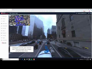
SOLV3D Encompass is a web-based solution for empowering data consolidation, visualization and collaboration. Bringing together a myriad of geospatial datasets, a wholistic view can be created in which visualization and collaboration between team members are easy.
SOLV3D Inc.
Calgary, AB, CA
Description
Bringing together a myriad of geospatial datasets, a wholistic view can be created in which visualization and collaboration between team members is intuitive and easy, yet incredibly powerful.
A simple interface providing access using only a web browser, Encompass rapidly expands the participation from a limited set of users to an entire enterprise - barriers based on physical location or software expertise no longer apply.
Perform functions such as;
- create groups to share projects and provide visibility to stakeholders
- simple measurements
- free-hand annotations
- create tags to link to additional information (PDF, video, external systems)
- overlay features (DXF, SHP files)
- incorporate streaming services (WMS/WMTS/WFS) and integrate ArcGIS Online maps
Request a product demostration or evaluation account - https://solv3d.com/solutions/Solv3DEncompass/
Specifications
-
Data management
-
Spatial reference system
-
Geometry types
-
Lines
Points
Surfaces
Raster
-
Other
-
License or freeware
-
2D Editing
-
Select
Remove
Graphic transformations
-
2D Construction
-
Positioning in relation to other element
-
Storage
-
Type of data storage
Input formats
Export formats
-
Visualisation
-
Types
Change view
Thematic mapping
-
Interoperability
-
Web standards
Spatial database management systems
Messaging protocols
Extensions
Metadata
-
General
-
Supported operation system
Main GIS category
-
Data analysis
-
Merge
Buffer
Overlay operations


