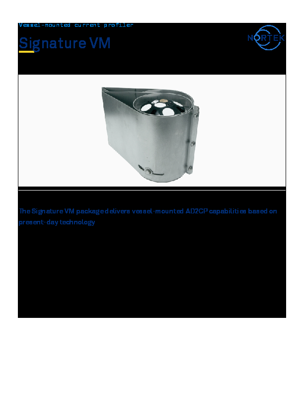
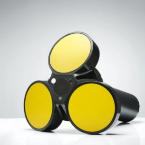
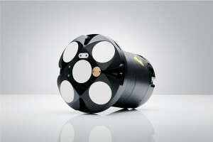
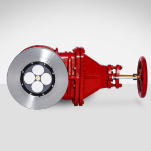
VM Coastal - 1000|500|250 kHz ADCP
Field-Proven Vessel-Mounted ADCPs for Commercial and Scientific Applications.
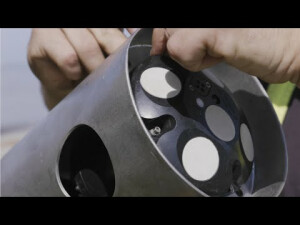
Nortek’s vessel-mounted ADCP current survey package – called Signature VM – opens up new and unprecedented opportunities to the community, while offering operational convenience and reduced complexity. Data quality can be safeguarded, and both errors and initial installation time can be substantially reduced by using an integrated system where each is module is pre-qualified.

Nortek
Rud, NO
Description
The VM Coastal safeguards data quality, opens up new and unprecedented opportunities to the scientific community, and offers operational convenience and reduced complexity.
The VM Coastal package includes the Signature1000, 500 or 250, allowing for great versatility in both the vessel-mounted and bottom-mounted configurations. By using a state-of-the-art and user-friendly vessel-mounted package, measurement errors and initial installation time can be greatly reduced.
Applications
- Coastal surveys, up to 200 m depth
- Port and harbour mapping
- Studies of tidal currents
- Sediment transport studies
- Large-scale mixing studies
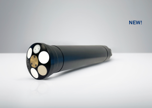
VM Coastal - 1000kHz
Fast pinging AD2CP for current measurements and high-resolution echograms in shallow water [30m]
Overview
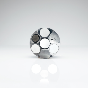
The VM Coastal 1000 kHz is an optimal instrument for smaller navigational rivers, estuaries and shallow coastal zones. The 16Hz ping rate permit concurrent measurements of current, depth, bottom track and water column echograms.
Echograms are measured with cm resolution down to the bottom, a common area with high suspended sediment load and where a standard VM-ADCP is not able to measure.
Obtaining data from a compact vessel or USV in a river or near-shore environment can be challenging due to sudden accelerations, course changes or wave-induced motion. The true heading GNSS time server and the optional AHRS accommodate extending the operational limit.
Coastal or river surveys are mostly transient installations. The compact VM-ADCP is convenient to be used on each vessel or USV. By using a state-of-the-art and user-friendly vessel-mounted package, measurement errors and initial installation time can be greatly reduced.
Highlights
- A coherent system that is quick and convenient to operate
- Fifth echosounder beam for sediment measurements down to the bottom
- Simultaneous current and depth information in one place
- High (16Hz) ping rate for profiling from smaller dynamic platforms and turbulent environments
- Ethernet ADCP and GNSS timeserver, offering tight network timing
- Optional AHRS for improved tilt compensation in dynamic environments
- Outstanding bottom-track performance [30m]
Applications
- Medium size USV's and manned vessels
- Navigational rivers, estuaries and coastal surveys, up to 30 m depth
- Current or turbulence studies
- Sediment transport studies
- Biomass studies
- River discharge studies using Qrev
- Studies of tidal currents
- Condition monitoring
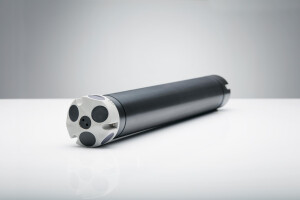
VM Coastal - 500kHz
Fast pinging AD2CP for current measurements and high-resolution echograms in the littoral zone [70m]
Overview
The VM Coastal 500 kHz is the right instrument for the larger navigational rivers up to coastal surveys. The 8Hz ping rate permits concurrent current measurements, depth, bottom track and water column echograms.
Echograms are measured with cm resolution down to the bottom, a common area with high loads of suspended sediment and where a standard VM-ADCP can't measure.
Obtaining data from compact vessels in large rivers or coastal environments can be challenging because of sudden accelerations, course changes or wave induced motion. The true heading GNSS time server and the optional AHRS can widen the operational limits.
The 70m bottom track range safeguards a proper velocity correction even in difficult conditions.
Coastal or river surveys are often transient installations. By using a state-of-the-art and user-friendly vessel-mounted package, measurement errors and initial installation time can be greatly reduced.
Highlights
- A coherent system that is quick and convenient to operate
- Fifth echosounder beam for suspended sediment measurement down to the bottom
- Simultaneous current and depth information in one place
- High 8Hz ping rate for profiling from medium size platforms or turbulent environments
- Ethernet ADCP and GNSS timeserver, offering tight network timing
- Optional AHRS for improved tilt compensation in dynamic environments
- Outstanding bottom-track performance, even in challenging conditions [70m]
Applications
- Large navigational rivers, estuaries and coastal surveys, up to 70 m depth
- USV's intended for estuaries or coastal environments
- Medium-sized inshore or coastal operating manned vessels
- Current or turbulence studies
- Sediment transport studies
- Biomass studies
- River discharge studies using Qrev
- Studies of tidal currents
- Condition monitoring
VM Coastal - 250kHz
Fast pinging AD2CP with range for vessels operating on the continental shelf [200m]
Overview
The VM Coastal 250 kHz grants precision, a high ping rate and range for those who want to cover the continental shelf.
By using a state-of-the-art and user-friendly vessel-mounted package, measurement errors and initial installation time can be greatly reduced.
Coastal seas can be a challenging environment to work in. Besides the true heading GNSS time server, the optional AHRS can widen the operational limits. The 200m bottom track range safeguards a proper velocity correction even in difficult conditions.
Highlights
- A coherent system that is quick and convenient to operate
- 3Hz ping rate for profiling from coastal vessel and environments
- Ethernet ADCP and true heading GNSS timeserver, offering tight network timing
- Optional AHRS for improved tilt compensation in dynamic environments
- Outstanding bottom-track performance, even in difficult conditions [205m]
- Optional 5th beam for current and wave measurements in stand-alone mode
- Increased pingrate & range, yet delivering the same accuracy alike slight higher frequency instrumentation on the market
Applications
- Large size offshore USV's and manned vessels
- Estuaries and deep coastal surveys, up to 200 m depth
- Current or turbulence studies
- Sediment transport studies
- River discharge studies using Qrev
- Studies of tidal currents
- Condition monitoring
Do you have questions about this product?
- Questions about price, availability, and/or retailers
- Questions about technical specifications and usage
- Questions about suitability for your project or application
Specifications
-
General
-
Max. operating depth [m]
300
True Bottom Tracking Capability
Y
Year of last update
2023
Length [m]
0.23
Width [m]
0.23
Height [m]
0.22
Weight in air [kg]
4.5
Weight in water [kg]
1
Min. operating power [V]
15
Max. operating power [V]
48
Max. battery lifetime [days]
365
Max. speed of boat [km]
43
Max. range to bottom [m]
205
Processor/memory
i5 processor/8 GB
Hard disk
500 GB SSD
Operating System
Windows 10
Housing Material
Non-corrosive
Dimensions
265x110x340mm
PC Input
24 VDC, 20W typical
Connections
Power, Signature ADCP, AN GNSS, 2 x HDMI, 2 x LAN,3 x USB, 2 x USB-C, 1 x RS232 (optional)
Operator control
Remote desktop or keyboard mouse
Total Weight [kg]
5,75
-
Other specifications
-
Real-time interfacing
Ethernet and serial
Min. external power [Voltage]
24
Max. external power [Voltage]
48
Max. cable length [m]
1000
Baudrate [kbit/s]
20000
External battery container
Y
Data acquisition software and processing software
Signature VM, Ocean Contour
-
Auxiliary Sensors
-
Conductivity
N
Oxygen
N
Turbidity
N
Tides
Y
Waves
Y
Pressure
Y
Acoustic modem
Y
Relocation of transponder
N
Wave direction
Y
Speed of sound
Y
-
Deployment method
-
Moving vessel
Y
Bottom mount
Y
Inline string mooring
Y
Data Buoy
Y
Marine structures
Y
-
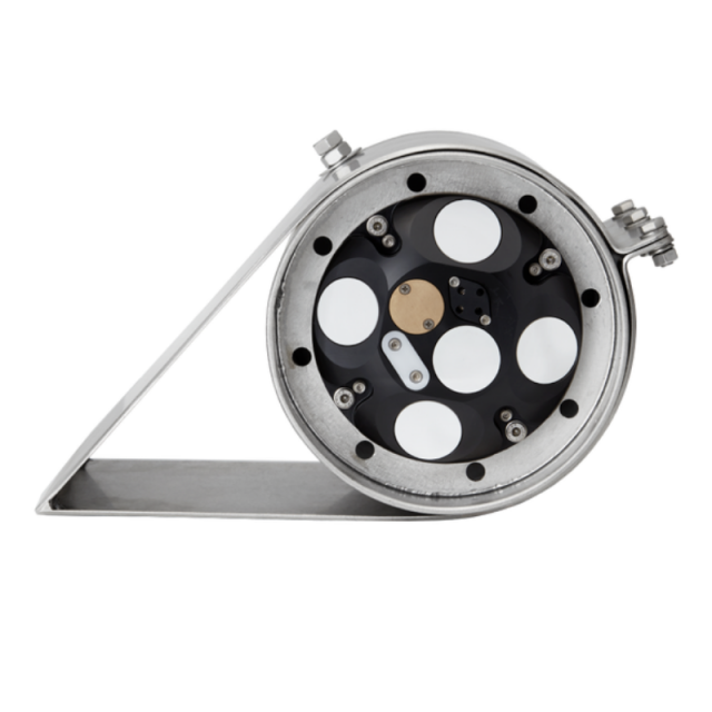
Doppler Current Profiler
-
Max. typical profiling range [m]
30/70/200
Number of beams
4 5
Nadir angle [deg]
25
Max. Number of cells per beam
256
Min. blanking distance [m]
0.2
Max. ping rate [Hz]
16
Min. cell size [m]
0.2
Max. cell size [m]
8
Speed dependent uncertainty: horizontal [%]
0.3
Speed independent uncertainty: horizontal [cm/s]
0.3
Center working frequency [kHz]
1000/500/250
Lost data at far boundary [%]
10
Cell overlap [%]
25
Max. velocity [m/s]
11.8
Speed dependent uncertainty: vertical [%]
0.1
Speed independent uncertainty: vertical [cm/s]
0.1
Surface reference capability
Y
Surface current measurement
Y
Compensation for sound speed
Y
Single ping rejection of outliers
Y
Maximum sampling rate for Water velocity measurements
15 Hz
Maximum sampling rate for Bottom velocity measurements
8 Hz
Maximum sampling rate for Depth measurements
4 Hz
No. of beams for Depth measurements
5
Single ping std
1 cm
Minimum altitude
0,2 m
Maximum altitude
205 m
Echo intensity Sampling
Yes
Echo intensity Resolution
0,5 dB
Echo intensity Dynamic range
70 dB
Echo intensity No. of beams
5
Echo intensity Beam width
2,9 degrees
Velocity resolution of Bottom velocity measurements
0,01 mm/s
Velocity resolution of Water velocity measurements
0,1 cm/s
Velocity resolution of Depth measurements
0,001 m
Storage temperature
-20 degrees C to 60 degrees C
Standard range
-4 degrees C to degrees 36 C
Pressure
300 m (please inquire for options)
Accuracy/precision
0,1% FS / Better than 0,002% of full scale
Compass and tilt
Yes, please inquire for optional AHRS
Data recording
16 GB, please inquire for options
Data cable
10m, please inquire for options
IO
Ethernet
DC Input
24 V DC or 120/230 VAC
Shock and vibration
IEC60068-2-64
EMC approval
IEC/EN 61000-6-2, 61000-6-3
Depth rating
300m, please inquire for options
Connectors
Straight fitted MCBH6F and MCBH8F
Housing
300m rated
Material
POM
Uncertainty of single ping horizontal velocity for default cell size [cm/sec]
4.71
Uncertainty of single ping vertical velocity for default cell size [cm/sec]
1.55
Minimum accuracy
0.5 cm/s
Long-term accuracy
Better than 0.5 cm/s
-
Standard Sensors
-
Temperature: min [°C]
-4
Temperature: max. [°C]
40
Temperature: uncertainty [°C]
0.1
Compass type
Solid State
Tilt: max. [deg]
90
Tilt: uncertainty [deg]
0.2
-
GNSS Positioning Sensor
-
Brand and model
Advanced Navigation, GNSS Compass Aries G2
Position accuracy (with dGNSS) / postprocessed
1,0m / 0,015m
Heading accuracy / post-processed
0,2 degrees
Supported navigation systems
Advanced Navigation GNSS Compass Aries G2
Protocol
AN packet protocol
Communication
Ethernet
Timing
PTP
-
Data and Software
-
Acquisition
Signature VM
Timing
PTP
Configuration
Signature VM, Signature Deployment
Display
Vessel track in map, Bottom-track velocity, Velocity magnitude and direction, Echo amplitude, Echo correlation, Vertical echogram; corrected relative volume
Status
GNSS and ADCP status displayed in Signature VM software
Output data
Binary AD2CP, NMEA data strings online (velocity, BT and depth) CSV, ASCII VMT, Qrev VMT, KML offline
-
Application
-
Typical applications
Vessel mounted coastal surveys, stand-alone use
Documents
Brochure
signature-vm-0.pdf
399.51 KB
