
Sams Series
Synthetic Aperture and Mapping Sonars
Exail’s Sams Series are next generation Synthetic Aperture Sonars (SAS) that offer both unrivaled range and resolution for subsea imagery operations in the most demanding conditions. Embedding their own positioning and navigation capabilities in addition to real-time SAS processing, the Sams Series SAS sonars provides optimal imaging performance in terms of swath, resolution, image quality, coverage rate and absolute pixel positioning accuracy.

Exail
Saint Germain en Laye, FR
Description
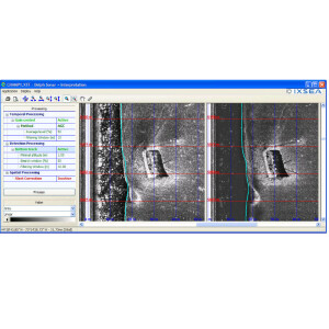
Real-time high-quality/high resolution geo-referenced subsea mapping
High quality data in the most severe environments
Combining acoustic imagery, inertial navigation and acoustic positioning data, Exail’s Sams Series are a new kind of synthetic aperture sonars (SAS) that drastically improve subsea imagery range-resolution ratio compared to traditional side-scan sonars.
Compared to traditional Side Scan Sonars (SSS) and other SAS technologies available, Exail’s innovative SAS sonar technology offers greater tolerance to the subsea vehicle movement and challenging operational conditions, ensuring high quality real time georeferenced data in the most severe environments.
Improved coverage rate
Providing real-time pixel georeferenced images of the seabed and avoiding distortion of the projection of the waterfall on the mosaic, the Sams Series enables high productivity survey by improving the coverage rate per hour with constant high resolution over the full swath.
Easy to deploy and to operate, Exail’s Sams Series offers the same operational advantages as traditional Side Scan Sonars, while delivering all key benefits offered by Synthetic Aperture Sonar technologies.
High-resolution interferometric bathymetry
Exail’s new-generation Sams Series sonars offers the ability to produce high-resolution bathymetric data using interferometry.
The in-house developed processing algorithms guarantee robust bathymetric data production in all conditions over the entire swath. This translates into improved data productivity compared with an onboard multibeam echosounder by up to a factor of 5.
Do you have questions about this product?
- Questions about price, availability, and/or retailers
- Questions about technical specifications and usage
- Questions about suitability for your project or application
Specifications
-
Towfish
-
Model identification
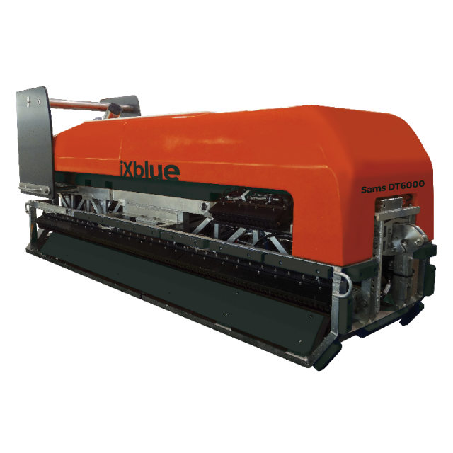
SAMS DT-6000
Length [m]
3.3
Weight in air [kg]
1100
Max. depth rating [m]
6000
Fish height from seabed determination method
USBL+INS+DVL+pressure sensor+SVP
Width [m]
1
Height [m]
1.5
-
Transceiver and recorder
-
Data processing and imaging capabilities
sonar imaging, bathymetry, subbottom profiling, magnetometry, pinger locator
-
System Description
-
System type
Integrated, Stand alone
Mode of operation
Simultaneous dual frequency
-
More information
-
Application
EEZ Mapping, Continental shelf extension, Marine Boundaries Delimitations, Law of the Sea, Environmental Monitoring, Debris survey, Pre-site survey, Cable Route Survey, Deep-sea mining, Marine Renewable Energy
Distinguishable features
Real-time multi-sensor data fusion: like a towed AUV, Sams platform can integrate other sensors such as: Multibeam Echosounder (for bathymetry and gapfiller backscattering imaging), Subbottom Profiler, Magnetometer, Pinger locator.
-
Operating frequencies
-
Max. frequency [kHz]
55
Max. Range [m]
750
Max. horizontal resolution [cm]
5
Max. operating speed [kt]
7
Max. vertical resolution [cm]
50


