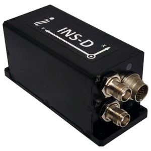
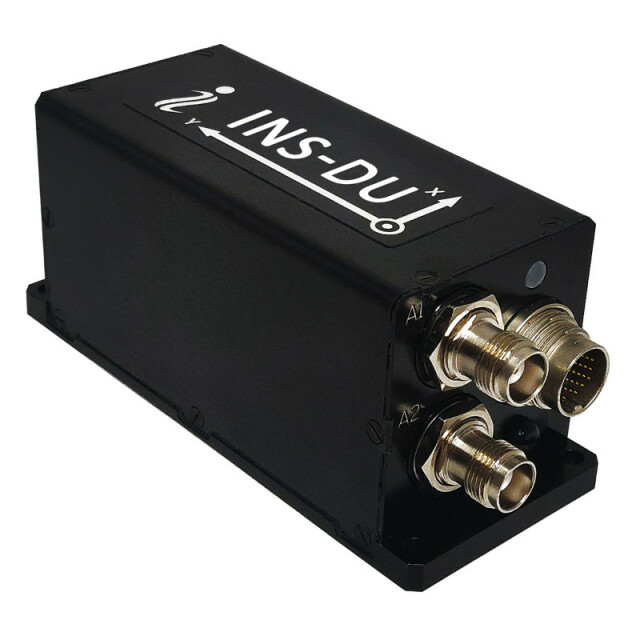


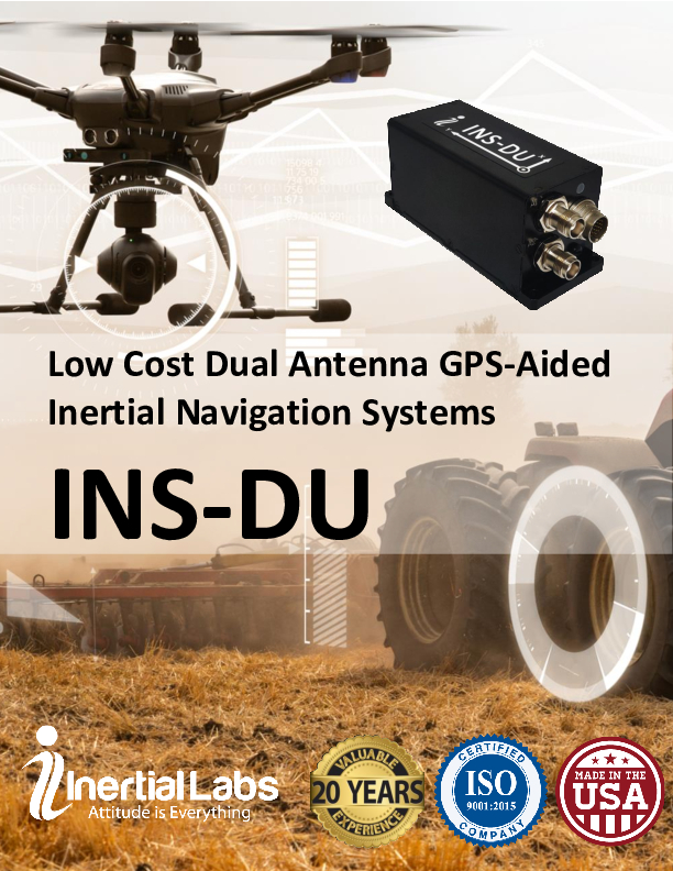
INS-DU – Dual Antenna u-blox GNSS Inertial Navigation System
Low Cost Dual Antenna Highly Accurate GPS-Aided INS for Precision Agriculture and many other applications
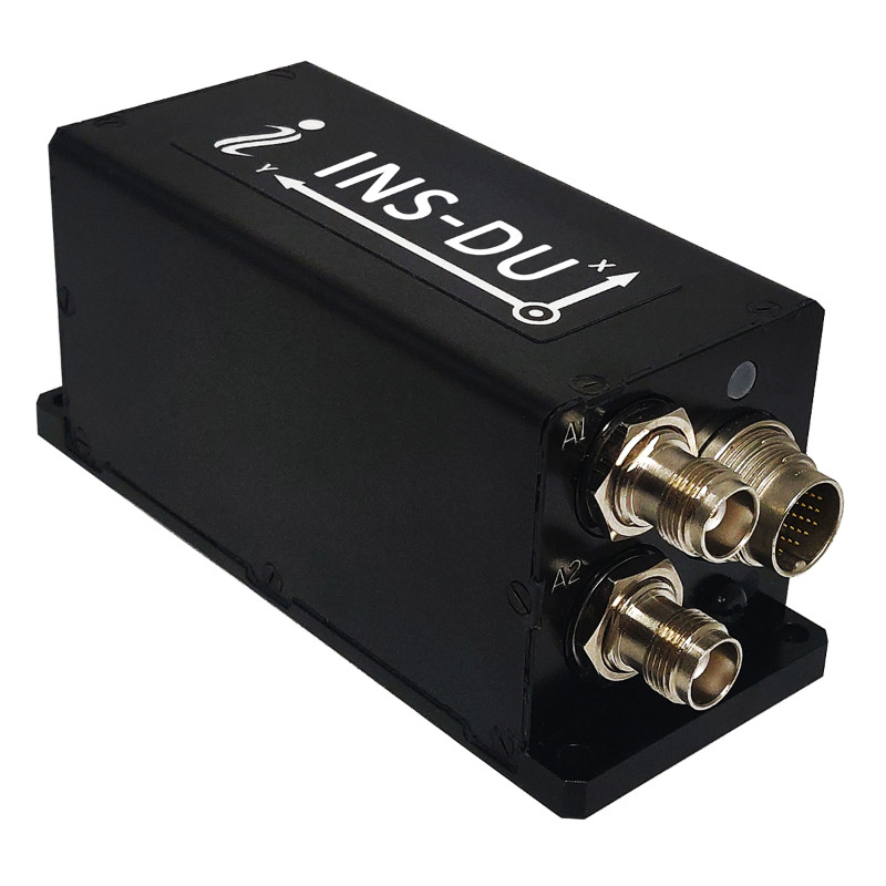
The new INS-DU is a high performance strapdown system that determines position, velocity, and absolute orientation to any platform that it is mounted to.

Inertial Labs, Inc.
Paeonian Springs, US
Description
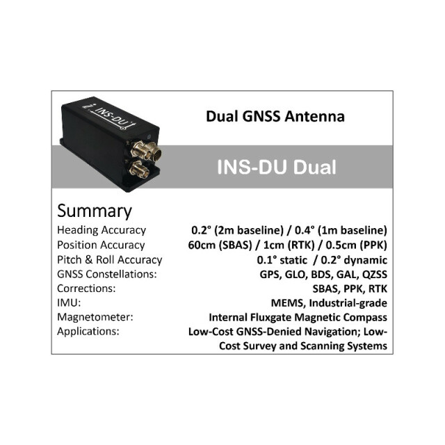
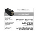
The INS-DU utilizes a cost-effective, dual antenna uBlox GNSS receiver that provides 1 cm RTK position from RTCM3 RTK corrections and supports a wide range of GNSS constellations. Designed for UAVs, Land Vehicles, and Marine Vessels, the INS-DU is an effective, low-cost solution that uses a range of aiding data for different applications. With highly accurate navigation in GNSS-denied environments, the INS-DU delivers a comprehensive GNSS-denied solution at a significantly lower price point.
One of the key elements to the success of the INS-DU is its use of the miniAHRS, which utilizes 3-axes each of precision magnetometers, accelerometers, and gyroscopes to provide orientation of the device under measure. It contains cutting-edge algorithms for the motion of robots, unmanned and autonomous vehicles, and antennas. MiniAHRS mini fluxgate magnetometers have a distinct advantage over commonly used magneto-inductive or magneto-resistive alternatives and have been a trusted North reference for over 70 years.
The INS-DU provides a full navigation solution for both GNSS and GNSS-denied environments at an unparalleled value. With custom interfaces and a power consumption of two and a half of a Watts, the INS-DU is a versatile solution fit for a wide variety of users with power consumption restrictions. In addition, the INS-DU contains our on-board sensor fusion filter, state of the art navigation, and guidance algorithms and calibration software.
Do you have questions about this product?
- Questions about price, availability, and/or retailers
- Questions about technical specifications and usage
- Questions about suitability for your project or application
Specifications
-
Other specifications
-
Export restrictions
ITAR Free
Graphical user interface
Y
Typical application
UAV, UGV, Remote Sensing, ROV, USV
Distinguishable features
New generation, low cost, high-performance, data-logging capable, GPS-denied capable
-
Environmental
-
Min. operating temperature [°C]
-40
Max. operating temperature [°C]
85
-
Software
-
Name
GUI
Filtering
Y
Adaptable input signals
Y
Integrity monitoring of position input
Y
Integrity monitoring of log input
Y
-
GNSS aided uncertainty
-
Heading [deg]
0.2
Pitch [deg]
0.1
Roll [deg]
0.1
-
General
-
Type of application
Air, Land, Marine
Year of initial development
2020
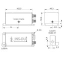
Height [mm]
53.2
Width [mm]
49.3
Length [mm]
120.5
Weight [kg]
0.32
Min. Voltage (DC)
9
Max. Voltage (DC)
34
Power consumption [W]
6
Splashproof casting
Y
Mean time between failures [hr]
55500
Type of accelerometer
MEMS
Type of gyro
MEMS
Removable from base plate
N
Moving parts
N
-
GNSS Positioning Sensor
-
Number of integrated GNSS receivers and antenna ports
2
No. channels p receiver
1
Tracked satellite signals
GPS L1C/A L2C, GLO L1OF L2OF, GAL E1B/C E5b, BDS B1I B2I, QZSS L1C/A L2C SBAS L1C/A: WAAS, EGNOS, MSAS, GAGAN
SBAS differential signals
Yes
RTK Network Compatibility
Yes
Update rate [ Hz ]
200
Cold start [ seconds ]
20
Hot start [ seconds ]
1
-
Data formats
-
NMEA formats
Yes
RTCM
Y
Other
Horizontal and Vertical Positions, Heading, Pitch & Roll, Velocity, Accelerations, Angular rates, Barometric data, PPS
-
GNSS positional accuracy
-
Horizontal Position Accuracy [ RMS in cm ]
1500
Horizontal Position Accuracy (SBAS) [ RMS in cm ]
1200
Horizontal Position Accuracy (RTK) [ RMS in cm ]
1
Documents
Brochure
ins-du-datasheet-rev2-3-march-2021.pdf
622.37 KB
![YRBKMWXn[1].png](https://cdn.geo-matching.com/En53gY1o.png?w=300&h=300&crop=1&s=024b01a5456af84a24979824702460d7)


