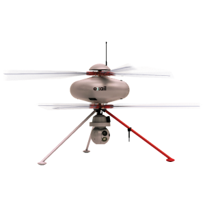

CW-007 Battery-operated VTOL PPK Mapping Drone
JOUAV
Chengdu, CN
Description
JOUAV CW-007 is a small VTOL drone for aerial survey, agriculture, surveillance and other fields. With simple operation that can be carried and operated by single person, full autonomous flight, vertical take-off and land, and total weight less than 7kg, modular design, no need any tools for assembly and dis-assembly, the electrical plug and the mechanical connection are completed synchronously, brand new power management module that the whole machine is powered by only one battery, which simplifies the user's operation process and improves the efficiency of power supply.
Specifications
-
Environment
-
Min. operation temperature [°C]
-20
Max. operation temperature [°C]
80
Max. wind speed [m/sec]
11
Max. humidity [%]
95
-
Imaging/scanning devices
-
Type of Camera
Sony
Build-in Stablilsation
N
Exchangeable
Y
Sensor tilting to allow oblique views
N
Onboard imaging/scanning devices
RGB Camera
-
Platform
-
Platform
Aircraft
Brand
JOUAV
Max. payload [kg]
1
Max. stay in the air [min]
90
Max. speed [km/h]
61.2
Max. height above sea level [m]
6000
Propulsion
Electric
-
Operation Characteristics and Safety
-
Min. ø of launch/landing site [m]
0
Launching method
Vertical takeoff
Automatic launch and landing
Y
Training provided
Y
Collision avoidance systems (CAS)
Y
Autonomous emergency landing
Y
-
Dimensions
-
ø / wingspan [cm]
220
Height [cm]
50
Weight [kg]
7.8
Weight of battery [kg]
2.5
Weight of filled fuel tank [kg]
0
Number of rotors
4
Transport on human back
Y
-
Base Station
-
Ground computer included
N
Sensor control
Y
Real time image and video download link
N
-
Navigation Sensors
-
Type of GNSS receiver and captured signals
RTK GPS
-
General
-
Year of last update
2021
Typical applications
mapping ,surveillance
-
Included software and automatically generated
-
Flight planning software
JOUAV AP Commander
Photogrammetric software
JOUAV AP Commander
Type of software included
Flight planning, Photogrammetric software
Automatically Generated Products


