Delph Sonar Software
Complete and highly productive geophysical acqusition and processing software designed to easily and accurately perform SSS and SAS surveys.
Delph Sonar is a complete acquisition, processing and interpretation software package designed to easily perform accurate and productive side-scan sonar (SSS) and synthetic apperture sonar (SAS) surveys. Providing an optimal QC at any stage and relying on Delph powerful workflow and ease-of-use, SSS and SAS mapping has never been so fast.

Exail
Saint Germain en Laye, FR
Description
Delph Sonar is a complete acquisition, processing and interpretation software package designed to easily perform accurate and productive side-scan sonar (SSS) and synthetic apperture sonar (SAS) surveys. Providing an optimal QC at any stage and relying on Delph powerful workflow and ease-of-use, SSS and SAS mapping has never been so fast.
Acquisition
Delph Sonar acquisition interfaces with most analog and digital SSS and SAS. With a dedicated interface for each, it provides a unified data logger to record raw data in industry standard XTF format.
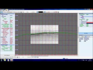
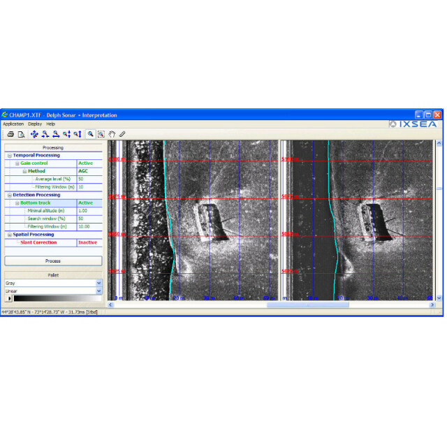
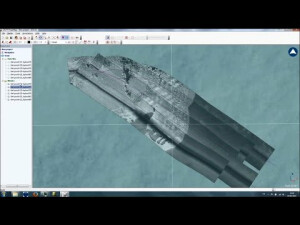
Interpretation
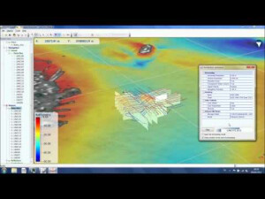
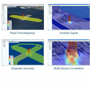
Delph Sonar interpretation is a dedicated tool for processing, analyzing and mapping any SSS and SAS data. Highly productive, it embeds high-level processing and benefits from Delph batch processing and mosaicking capabilities. The 2D profile view and 3D geographic visualization provide global QC and fast integration with other data types.
Features
FFor SSS
- Opened to most digital side-scan sonars
- Driver-based interfacing
- Single and dual frequency support
- Easy interfacing to navigation data
- Quality control indicators
- Raw data logging to XTF format
FFor SAS
- Accurate absolute positioning in real-time
- Full resolution INS-based navigation and motion
compensation - Real-Time USBL data fusion (optional)
- Micro-navigation computation
- Native production of industry standard XTF records and
geoTIFF mosaics
Do you have questions about this product?
- Questions about price, availability, and/or retailers
- Questions about technical specifications and usage
- Questions about suitability for your project or application
Specifications
-
General
-
Year of initial development
2014
Area of Application
Geophysical exploration, Geotechnical investigation, Structural geology, Cable route survey, Hydrographic survey, Habitat mapping, Pipeline inspection, Unexploded ordnance survey, Marine archaeology
-
Geodetic Functionality
-
Supported datum transformations
Y
Geographical coordinates (Lat, Long)
Y
Ground coordinates (E,N)
Y
Seven Parameter shift supported
Y
Separation model for vertical datum shift support
Y
Local datum support
Y
-
Data / System Support
-
Recorded data storage formats
24-bit analog to digital conversion, Opened to all SEGY and XTF formats
Supported Hydrographic Systems
Opened to most digital side-scan sonars. Single and dual frequency support. Easy interfacing to navigation data.Raw data logging to XTF format
Supported AUVs
All with XTF and SEGY output
Supported ROVs
All with XTF and SEGY output
Supported ROTVs
All with XTF and SEGY output
Metadata management
Y
-
Online capabilities
-
3D real time display
Y
Supported 3D display data
Y
-
Hardware requirements
-
Processor (CPU)
Documents
Brochure
delph-suite.pdf
285.4 KB
