Agricultural guidance mobile application geotrack with GM SMART GNSS receiver
Low-Cost and Accurate Solution for Agricultural Guidance
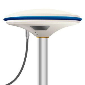
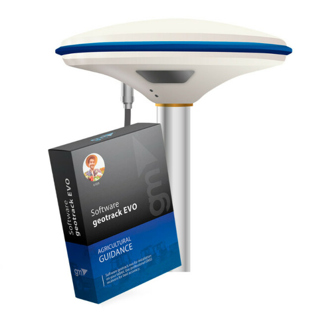
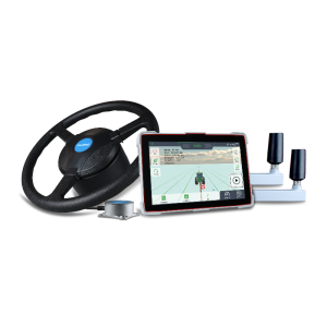
The kit of equipment: geotrack software with GM SMART receiver for your tablet or smartphone is the optimal kit that will allow you to create your own agricultural guidance system to precisely control the wide-reaching equipment during field work such as spraying, spreading fertilizers and applying plant protection products. The kit is ready to install on your mobile device with Android OS, and includes an external GM SMART receiver, which can be connected by Bluetooth to improve the pass-to-pas
Geometer International LLC
Dnipro, UA
Description
LOW-COST AND ACCURATE SOLUTION FOR AGRICULTURAL GUIDANCE
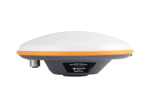
The kit of equipment: geotrack software with GM SMART receiver for your tablet or smartphone is the optimal kit that will allow you to create your own agricultural guidance system to precisely control the wide-reaching equipment during field work such as spraying, spreading fertilizers and applying plant protection products. The kit is ready to install on your mobile device with Android OS, and includes an external GM SMART receiver, which can be connected by Bluetooth to improve the pass-to-pass accuracy. The GM SMART receiver has a special software smooth filter, which was developed for use in agriculture. Thanks to the smooth filter feature high accuracy of parallel driving is provided. The receiver has 335 channels to work with all available satellite systems: GPS, GLONASS, GALILEO, BEIDOU, QZSS, SBAS. Provides accuracy of parallel driving, at the level of 15 cm from pass-to-pass.
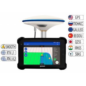
The system displays information for precise guidance of the equipment, records the trajectory of the equipment in the form of a track and accurately calculates the cultivated area. Thanks to the licensed geotrack software, working with this kit will be convenient and easy. It has an intuitive menu, so it does not require special training of the operator. Synchronization of fields and works via Wi-Fi/3G/4G/LTE with the Agroprofile portal will greatly facilitate work with the device and provide the possibility of remote control of workers who are in the field.
As a monitor you can use your own tablet or smartphone with Android OS, which will be installed licensed software geotrack. This software includes technical support directly from the developer. In addition, the program is regularly improved and updated according to the needs of modern farmers. If necessary, you can update your program to the latest version.
To install the software you will need a device with the following minimal technical parameters:
| Operating system | Android, version 9.0 and above |
| Google Mobile Services (GMS) | necessarily (Google Maps, Play Market) |
| Display | 7 inches or bigger |
| RAM | 2 Gb and more |
| Bluetooth | yes |
| Wi-Fi | yes |
| SIM-Card | optional if you need an online tracking feature |
The agricultural guidance system is suitable for such works as sowing, spraying plants against weeds and pests, application of mineral and organic fertilizers. The joint use of the GM SMART receiver and the geotrack program makes it possible to accurately control agricultural machinery in the field in conditions of poor vision - at night, in fog, in conditions of heavy dust.
Pass-to-pass accuracy:
- 15-20 cm
- 1-3 cm (RTK mode)
Equipment:
- Receiver GM SMART
- Mobile application geotrack
Functionality:
- Accurate guidance from pass-to-pass
- Accurate area measurement
- Treatment of saved fields
- Determining the treated area
- Visualization of the treated area
- Displaying the movement speed
- Displaying azimuth
- Five guidance patterns
- Adjustment of width of equipment (to centimeters)
- Online technical support
- Saving a field map
- Automatic saving works
- Specifying Job Types (sowing, spraying, etc.)
- Support for RTK L1
- Optional support for RTK L1/L2
- Online sync with Agroprofile
Operating modes:
- Area measurement
- Area measurement with offset
- Free guidance mode
- Straight A-B
- Curve A-B
- Perimeter - Straight A-B
- Perimeter - Curve A-B
What data is displayed while driving:
- Treated area
- Travelled length
- Speed of movement
- Number of satellites
- Satellite signal quality (HDOP)
- Visual guidance tips
- Calculation of working time
- Count overlapping
- Visualization of overlapping
- Ratio: work done / in process
Specifications
-
Performance
-
Tracked satellite signals
GPS, BeiDou, GLONASS, Galileo, QZSS, SBAS
No. channels
335
-
Terrain compensation / INS
-
Terrain compensation module
-
Communication and data
-
Bluetooth
Y
