Coal Mining Operations Use Laser Scanners to Verify Stockpile Volumes
The hallmark of most highly-successful companies is an ability to adapt to change. Case in point: when confronted with a change in regulatory policy affecting how its stockpiles could be verified, coal mining operations in central Alabama demanded immediate compliance from the engineering firms that oversee that activity for them.
For PERC Engineering which counts several mine and quarry operators as some of its most key clients, their response met the challenge: they supplemented their traditional surveying strengths with a laser scanner. The result has been a new component to its business, additional market possibilities and, most importantly, a satisfied customer.
Getting Stockpile Numbers
Founded in 1981, PERC Engineering (the acronym originally stood for Permitting, Engineering, Reclamation and Consulting) offers a broad range of services covering everything from civil engineering, to testing, to surveying, to mine engineering. According to 26-year veteran Lynell Early, the company’s vice president of surveying, doing work of one kind or another for area mines has been a big part of the company’s focus for a long time. “One of those tasks includes verifying onsite inventories,” he said. “That can include piles of material that have already been mined or quarried or material that remains in place awaiting such action.”
Early said there are alternative methods to verification, such as tracking volumes as they leave a site by truck, or relying upon aerial photography but cites the high costs, in time and dollars, of doing so.
“So, many of the operators turned to engineer firms like us to survey the piles or benches and give them their numbers. And that’s what we did for a lot of years.”
"There is no doubt in my mind that we are getting a more representative reading of what’s there than if we were out there with a stick."
PERC Engineering's Vice President of Surveying, Lynell Early
Changing Mines with Laser Scanners
The change in practice at PERC’s clients’ operations was the result of a mandate from the Mine Safety and Health Administration (MSHA) which said that mine operators had to ensure the safety of any personnel walking on piles of material which had reclaim tunnels beneath them. According to Early, traditional surveying of a client’s material piles, many of which did, in fact, have tunnels beneath them, couldn’t be done without walking the piles.
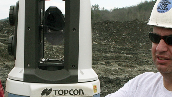
“Any ‘traditional’ alternative approaches were either too cumbersome or too slow,” he said. “Fortunately for us, we’d been regularly attending seminars that our equipment supplier, Earl Dudley Inc. in Birmingham, had been putting on, several of which covered the use of Topcon’s GLS-1000 Laser Scanner. We didn’t know it at the time, but we were looking at the tool that would help us meet our customer’s, and MSHA’s, challenge.”
By design, the Topcon GLS-1000 was a perfect fit for PERC Engineering’s needs. The unit sends out a laser beam that captures data at 3,000 points per second at a range of 500 ft. to a typical surface and can offer an extended range to 1100 ft. for more reflective surfaces. The result of scanning is a dense “point cloud” that can be post-processed to yield three-dimensional [x, y, z] models of the object or surface being scanned
“It was exactly what we needed; we couldn’t wait to get familiar with it and put it to work in the field,” says Early.
Less office time spent verifying stockpile volumes
PERC’s first test at an operator’s site proved to be “too much of a good thing.” They shot a stone pile which was about 1,000 feet in length which, using standard surveying techniques, would normally generate anywhere from 1,500 to 2,000 points.
“Using the GLS-1000, and ten separate scans, we got more than five million points,” said Early. “While that was impressive, we then realized we had to deal with managing that many points to create our model. Now, we generally do no more than seven scans which give us about 400,000 points and a nice manageable point cloud.”
While there is more in-office time spent manipulating the data after the scan (compared to a traditional surveying approach), Early says there’s no denying the fact that the laser scanner produces both a better product and real, measurable savings.
“On an application like this [volume verification], the accuracy is far better with the scanner than what we could do otherwise. We are actually getting the shape of the pile; if it gradually curves, we get that. There is no doubt in my mind that we are getting a more representative reading of what’s there than if we were out there with a stick.”
As to savings, he says that, in mining applications alone, they can now do the same amount of work with three men as they used to do with three crews.
“And we are continually bringing the ‘office time’ down as our people become more and more proficient with the ScanMaster software at cleaning up the point clouds, stitching together files to create the models, and so on. What’s important is that we are confident the savings in field time will allow us to get and do more work without adding more people. That’s a benefit we hadn’t foreseen.”
¨Yes We (laser)Scan¨
As impressive as PERC Engineering’s experience with the scanner has been to date, Early says they feel they have only scratched the surface with regards to how they can benefit from it. They see a range of different uses including highway construction projects, utility installation projects, improvements in commercial properties, and as part of a municipal GIS effort.
“We recently used it on a project in which a customer suspected that a high-tension tower was subsiding because of mining activities beneath it. So we scanned the tower before the mining activity and then again a month later and presented the findings to our customer. It was determined that one of the anchors had moved, resulting in a minimal twist of the tower of about six or seven inches. Just to be able to give them a representative 3-D model of the results was really a nice feather in our cap.”
Do you have questions about this case study?
Get in touch with Topcon, and they would be happy to answer any questions you have about pricing, suitability, availability, specs, etc.
Related products


![3月21日-封面[1].jpg](https://cdn.geo-matching.com/voeE1ywo.jpg?w=320&s=6b3b1a0215d770f8797653e9202a8f52)


