Boxfish ROV Deepsea Deployment
With the Boxfish remotely operated vehicle (ROV), port authorities are able to perform underwater inspections efficiently and regularly, and without having to incur high costs. Ports of Auckland (POAL) was looking for an ROV to conduct a video survey at depths reaching 710 metres to identify and map out underwater ecosystems and habitats.
Boxfish ROV Deepsea Deployment
POAL was required to conduct a survey at the site which was an extremely difficult environment to access and reaching depths of over 700 metres below sea level.
The team looked at a few options, but after extensive research, they were particularly impressed with the Boxfish ROV due to its compact size, easy to use technology, and crisp video and image capabilities.
Additionally, the Boxfish ROV has a large capacity built-in battery, allowing the vehicle to deploy to their survey areas of interest, with depth ratings up to 1000 metres!
Take a look at the video and get to know more about the Boxfish ROV and its recent underwater inspection with Nigel Ironside, Senior Environmental Advisor at Ports of Auckland.
A Day in the Life during Deepsea Surveying
During the deployment with the Boxfish ROV, POAL surveyed 15km in multiple runs, with more than 1km taken on a single battery charge. It was critical that the team was able to identify where they were in relation to the ROV in the water. The subsea positioning details were identified by using a USBL Blueprint Subsea Seatrac while the Boxfish ROV and the cage fitted with beacons rated to 1,000 meters were used to indicate their positions to the surface. This was extremely beneficial during the deployment!
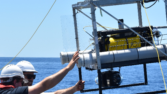
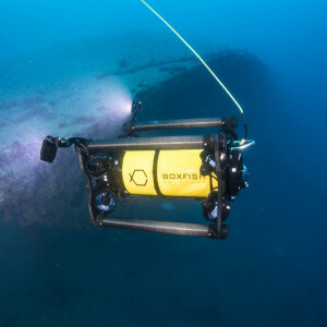
Once the system was in position over the desired survey area, POAL released the ROV and reversed it out of the cage. Specific features of the seafloor were then investigated via the ROV’s image and video capabilities.
The height above the seafloor was approximately one to two metres, and the ROV angle was pitched downward at about 30 degrees. The team was also able to adjust the pitch during the survey to suit the changing (and sometimes unpredictable) water conditions.
''While we had an idea of what might lay beneath the surface, due to published data, Boxfish was able to confirm the environment at 710 meters depth for us!'' - Nigel Ironside, Senior Environmental Advisor at Ports of Auckland
Back to the Numbers!
During the survey, 4K video was collected at the surface and recorded directly to a high-speed SSD device. The team logged the data regularly and recorded the following incredible results:
-
A total of 15 dives were conducted
-
Max depth reached was 710 metres
-
1,000m of tether deployed
-
Up to 550m of horizontal separation, ROV to boat
-
15 minutes for boat-to-seafloor deployment at 610m
-
25-30% of ROV battery life per 1km of seafloor (approx. 30 minutes)
-
75-minute deployment-to-recovery time per transect
Learn more about how Boxfish ROV can help you conduct your next underwater survey, contact us today!
Related articles


![3月21日-封面[1].jpg](https://cdn.geo-matching.com/voeE1ywo.jpg?w=320&s=6b3b1a0215d770f8797653e9202a8f52)


