![hqdefault (1239).jpg](https://cdn.geo-matching.com/3n8lGen5.jpg?w=300&s=d911a68ed36d4b345024da37c37e23f8)
![new-logo.jpg](https://cdn.geo-matching.com/wpXDN2pX.jpg)
Showing 1-6 of 6 results
![hqdefault (1239).jpg](https://cdn.geo-matching.com/3n8lGen5.jpg?w=300&s=d911a68ed36d4b345024da37c37e23f8)
![hqdefault (1241).jpg](https://cdn.geo-matching.com/1o4ZMAnG.jpg?w=300&s=a186df46e799e33f3c818ec6820ba37c)
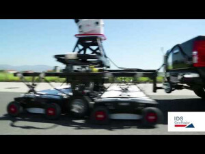
Pegasus:Stream - Ground penetrating radar for mobile mass data collection
![hqdefault (882).jpg](https://cdn.geo-matching.com/kpb1BJn3.jpg?w=300&s=d725f47d4d925d4f2ed210d62c208a1f)
Stream UP - The easiest way to capture underground utility assets
![hqdefault (127).jpg](https://cdn.geo-matching.com/jpGr5Enm.jpg?w=300&s=079be3c5ecc9a650f4c706bf7f8f28e7)
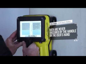
C-thrue - See Thru Concrete Structures and Reveal True Data that Lead to Optimal Decision-Making
![hqdefault (1240).jpg](https://cdn.geo-matching.com/OomLP9pw.jpg?w=300&s=31ca8cebafb48fd35dbdbe3e85d3ce1f)
Stream C - The Compact Array Solution for Accurate 3D Utility Mapping
![hqdefault (103).jpg](https://cdn.geo-matching.com/9p65zvnb.jpg?w=300&s=f6c9854742d3a7659ace2ba9ea09182d)