![hqdefault (881).jpg](https://cdn.geo-matching.com/PoxO6epD.jpg?w=300&s=86829c12e91dd0644a06402fd0098a18)
Showing 1-9 of 18 results
![hqdefault (881).jpg](https://cdn.geo-matching.com/PoxO6epD.jpg?w=300&s=86829c12e91dd0644a06402fd0098a18)
![hqdefault (880).jpg](https://cdn.geo-matching.com/YRBDBqpO.jpg?w=300&s=cf1dc16eb2526a4b8d45d0dcd1e6b5ed)
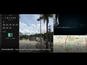
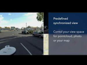
VisionLidar365 How to Get Your Point Clouds in the Cloud
![hqdefault (870).jpg](https://cdn.geo-matching.com/9p65Pqnb.jpg?w=300&s=855b923709641e8d6a8215dfd1787afd)
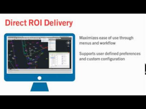
Our Field-to-finish solution that integrates into your CAD
![hqdefault (358).jpg](https://cdn.geo-matching.com/YRBDQVpO.jpg?w=300&s=6a92163103f203e6eacc90b061933c32)
VisionCivil
![hqdefault (51).jpg](https://cdn.geo-matching.com/1pPJ53Rm.jpg?w=300&s=4786e7121c133ffbc94400df4f43fe7c)
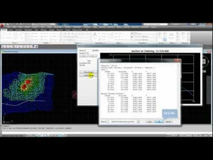
VisionCivil (EN) Create & Visualize Sections
![hqdefault (54).jpg](https://cdn.geo-matching.com/1pAPAPnP.jpg?w=300&s=925d9cfb95a228d1e468e8831d8d5808)
VisionCivil (EN) Create Road
![hqdefault (53).jpg](https://cdn.geo-matching.com/9p65qMnb.jpg?w=300&s=2168dae7d78276d49bd3b90919cd5933)
VisionCivil (EN) Create Platform & Calculate Excavation Volume
![hqdefault (52).jpg](https://cdn.geo-matching.com/qoDAleR7.jpg?w=300&s=fb431cad146ebb1530a283e43c8a7cb4)
VisionCivil (EN) Create Surface & Contour Line
![hqdefault (50).jpg](https://cdn.geo-matching.com/7o2Nkmo5.jpg?w=300&s=f9c6e2673b3e85812c679616c4d7831b)