![hqdefault (365).jpg](https://cdn.geo-matching.com/PnjaQGRa.jpg?w=300&s=3f64c3bd23237eb48c613254b4b5c3e4)
![world-water-day-banner-landscape-1200-300-px.png](https://cdn.geo-matching.com/3n8aDbp5.png)
![migrationn8ugke.jpg](https://cdn.geo-matching.com/jpG3Vypm.jpg)
Showing 1-9 of 14 results
![hqdefault (365).jpg](https://cdn.geo-matching.com/PnjaQGRa.jpg?w=300&s=3f64c3bd23237eb48c613254b4b5c3e4)
![hqdefault (366).jpg](https://cdn.geo-matching.com/9pNxe4RZ.jpg?w=300&s=38d0eee2ec75550084ecef5994b61b69)
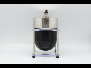
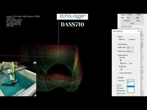
3D imaging sonar DASS710 Pole mounted Deployment
![hqdefault (367).jpg](https://cdn.geo-matching.com/6py3NlRj.jpg?w=300&s=a8b0885c67acc3b9e1144a8ae7787911)
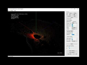
Echologger DASS710 (3D scanning sonar) deployed on the underwater holder stand
![hqdefault (711).jpg](https://cdn.geo-matching.com/xRKg6rR2.jpg?w=300&s=ebb9c33daa18817fbe82cff4b8f13480)
BlueROV2: Echologger MRS900 Scanning Sonar Testing
![hqdefault (60).jpg](https://cdn.geo-matching.com/9p65kvnb.jpg?w=300&s=b18028cf314e27bf1caa864351eb7d38)
Echologger ECT D24 on an autonomous boat
![hqdefault (220).jpg](https://cdn.geo-matching.com/jpGr4Lnm.jpg?w=300&s=575018c71a12e17fb4bb7fa64a4ca79e)
Mapping a Lake with ArduPilot
![hqdefault (221).jpg](https://cdn.geo-matching.com/Zpzk5voK.jpg?w=300&s=c70877c45cde8c718d58474f6cc02d02)
Automatic flight of the bathymetric drone with an echo sounder
![hqdefault (119).jpg](https://cdn.geo-matching.com/EoOb95p0.jpg?w=300&s=9e9535eea8b27d312712638094c0d7e4)
Bathymetric survey at Ulverston Bay, Texas
![hqdefault (576).jpg](https://cdn.geo-matching.com/MpVjkYpe.jpg?w=300&s=f3160fb9512bfcfbb040ddde574d7211)