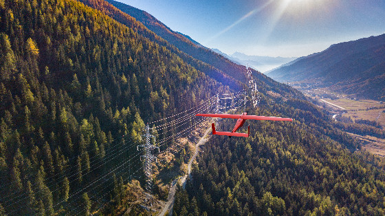
Unmanned Aerial Vehicles Used in Aerial High-Voltage Power Line Survey
Сorridor mapping services for high voltage lines by unmanned aerial vehicles Geoscan. The survey technology Geoscan allows you to restore the wires in a photogrammetric way, which makes the process cheaper and faster than laser scanning.
Power Lines Survey
Results:

Orthomosaics
As KMZ file (plan accuracy not worse than 15 cm)
![]()
Digital Terrain Models
As TIFF or KMZ file (height accuracy not worse than 15 cm)
![]()
3D reconstruction of wires
Models are provided as KML file
![]()
Power lines inspection cards
Provided as an XML file.
Besides the report and all data sets a specialized GIS "Sputnik PTL" with uploaded survey results is provided.
“Sputnik PTL” is a convenient tool for power lines analysis and assessment


Our model allows you
- measure slack of the wire and its clearance to earth;
- measure the forestry area;
- find out the vegetation dangerous to wires;
- measure distances with respect to the terrain;
- measure slops, a difference of height, ground distance;
- measure the area on the digital terrain model (DTM) and digital surface model (DSM);
- export the reports as an XML file;
- render the trees impact zones.
Application fields

Prevention of emergency situations (dangerous vegetation, wire slack)
- Monitor trees and shrubs dangerous to wires
- Define the compliance of wire slack
- Model the impact of the tree zones

Scheduled monitoring
- Detect irregularities within exclusion zones of HVL
- Monitor trees and shrubs growth
- Measure wire clearance to earth

Power lines maintenance (maintenance, lines reengineering)
- Plan the forest corridors widening
- Plan ground maintenance
- Plan power lines reengineering

Mapping
- Count the number of trees growing in the exclusion zone
- Measure the height and diameter of the trees of trunks
- Zone trees and shrubs by height
- Value the cut and slash


![3月21日-封面[1].jpg](https://cdn.geo-matching.com/voeE1ywo.jpg?w=320&s=6b3b1a0215d770f8797653e9202a8f52)


