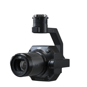
P4 Multispectral
Plant Intelligence for Targeted Action
Gather precise plant-level data using the P4 Multispectral – a high-precision drone with a seamlessly integrated multispectral imaging system built for agriculture missions, environmental monitoring, and more.

DJI ENTERPRISE
Shenzhen, CN
Description
DJI AirWorks
Through the annual AirWorks conference, DJI drives the commercial drone industry forward as AirWorks is a hub for innovation and growth, enabling participants in this ecosystem to exchange ideas, gain more control of drone technology, and steer the future development of the industry.
Join hundreds of commercial drone professionals and technology experts at the in-person DJI AirWorks conference in Las Vegas from October 10-12, where you can be a part of the leading discussion on the future of drone technology, share your growth stories, and exemplify the impact of drone technology on your business.

Farm to Figures
Gain Immediate Insights into Plant Health
The P4 Multispectral consolidates the process of capturing data that gives insight into crop health and vegetation management. DJI has created this platform with the same powerful performance standards that DJI is known for, including 27 minutes max flight time and up to 7 km1 transmission range with the OcuSync system.
See Beneath the Surface
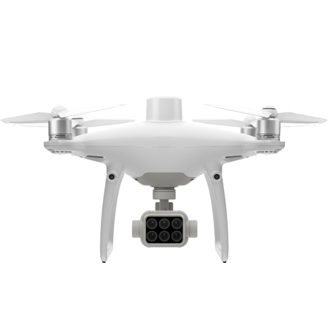
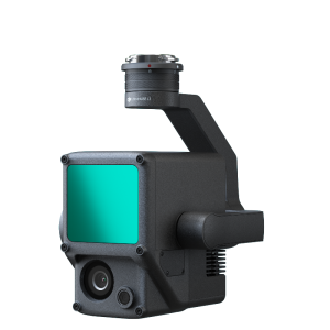
Agriculture imagery collection is now simpler and more efficient than ever before with a built-in stabilized imaging system that collects comprehensive data sets right out of the box. Access information collected by 1 RGB camera and a multispectral camera array with 5 cameras covering Blue, Green, Red, Red Edge, and Near Infrared bands – all at 2 MP with global shutter, on a 3-axis stabilized gimbal.
Integrated Spectral Sunlight Sensor for Accurate Results
An integrated spectral sunlight sensor on top of the drone captures solar irradiance, which maximizes the accuracy and consistency of data collection through different times of the day. When combined with post-processed data, this information helps to obtain the most accurate NDVI results.
Meaningful Data at Your Disposal
View Both RGB and NDVI Feeds
Simply having aerial imagery is not enough for ag professionals who want to know more. Switch between a preliminary Normalized Difference Vegetation Index (NDVI) analysis and the live RGB feed to immediately visualize where attention is needed, so targeted treatment decisions can be made quickly.
Centimetre-level Precision
Get real-time, accurate positioning data on images captured by all six cameras with DJI’s TimeSync system, providing centimeter-level accurate measurements. The TimeSync system continually aligns the flight controller, RGB and NB cameras, and RTK module, fixing the positioning data to the center of the CMOS and ensuring each photo uses the most accurate metadata. All cameras go through a rigorous calibration process where radial and tangential lens distortions are measured. The distortion parameters gathered are saved into each image’s metadata, letting post-processing software adjust uniquely for every user.
D-RTK 2 Mobile Station and NTRIP Compatibility
Enhance the accuracy of RTK positioning without an internet connection by connecting the P4 Multispectral to the D-RTK 2 High Precision GNSS Mobile Station and NTRIP (Network Transport of RTCM via Internet Protocol)2, or store the satellite observation data to be used for Post Processed Kinematics (PPK).
The Beginning of Intelligent Agriculture Missions
Plan Flights
Plan flights, execute automated missions, and manage flight data using GS PRO – DJI’s leading flight planning iOS app.
Capture Data
Collect multispectral images efficiently across a large area using the P4 Multispectral and gain an overview of problem areas.
Analyse Data
Easily access and process aerial data by applying plant-specific metrics and parameters to acquire the desired results on plant health.
Act on Data
Implement targeted treatments on areas that need attention based on accurate drone data.
Applications:
Precision agriculture
Throughout all growing seasons, multispectral imagery can be helpful to ag professionals by providing information invisible to the human eye across the electromagnetic spectrum. Having access to this data and the subsequently obtained Vegetation Index data such as NDRE and NDVI, farmers can make timely, informed decisions on crop treatment, lowering costs, saving resources, and maximizing yields.
Environmental monitoring and inspection
Routine inspections and maintenance involving plants can be made smarter and more efficient when using the P4 Multispectral – leverage its actionable multispectral insights to monitor forest health, measure biomass, map shorelines, or manage riparian vegetation while protecting habitats or ecosystems, and much more.
Do you have questions about this product?
- Questions about price, availability, and/or retailers
- Questions about technical specifications and usage
- Questions about suitability for your project or application
Specifications
-
Environment
-
Min. operation temperature [°C]
-10
Max. operation temperature [°C]
40
-
Battery and Power
-
capacity
5870 mAh
energy
89.2 Wh
Battery type
LiPo 4S
operating temperature
-10° to 40° C
-
Imaging/scanning devices
-
Onboard imaging/scanning devices
Exchangeable
N
-
Platform
-
Brand
DJI
Max. stay in the air [min]
Approx. 27 minutes
Max. speed [km/h]
58
Maximum rate of ascent
6 m/s (automatic flight); 5 m/s (manual control)
Maxirum rate of descent
3 m/s
Weight (with cooling fan)
1487 g
-
Operation Characteristics and Safety
-
Automatic launch and landing
Y
Autonomous emergency landing
Y
Collision avoidance systems (CAS)
Y
-
Dimensions
-
Weight of battery [kg]
0.468
Number of rotors
4
-
General
-
Year of last update
2020
Typical applications
Precision agriculture, Environmental monitoring and inspection
Product Name
P4 Multispectral
-
Included software and automatically generated
-
Type of software included
Automatically Generated Products
NDVI maps
Flight planning software
GS PRO
Photogrammetric software
DJI TERRA
Documents
Brochure
p4m-brochure-en-a5-read-20190917.pdf
7.77 MB
Videos


