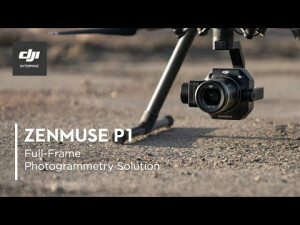
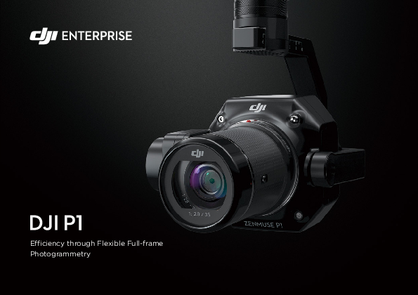
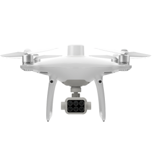
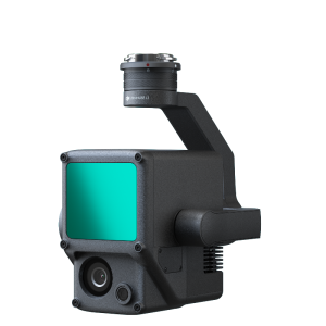
Zenmuse P1
Efficiency Through Flexible Full-frame Photogrammetry
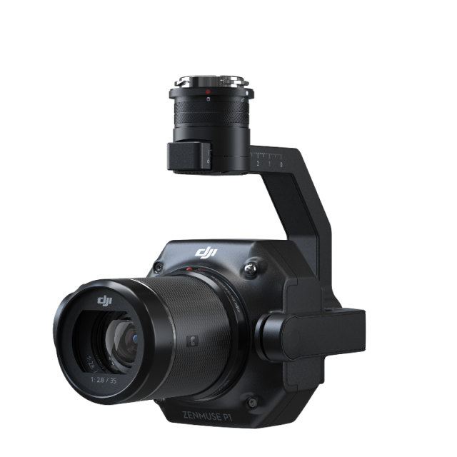
The New Benchmark for Aerial Surveying the Zenmuse P1 integrates a full-frame sensor with interchangeable fixed-focus lenses on a 3-axis stabilized gimbal. Designed for photogrammetry flight missions, it takes efficiency and accuracy to a whole new level.

DJI ENTERPRISE
Shenzhen, CN
Description
DJI AirWorks
Through the annual AirWorks conference, DJI drives the commercial drone industry forward as AirWorks is a hub for innovation and growth, enabling participants in this ecosystem to exchange ideas, gain more control of drone technology, and steer the future development of the industry.
Join hundreds of commercial drone professionals and technology experts at the in-person DJI AirWorks conference in Las Vegas from October 10-12, where you can be a part of the leading discussion on the future of drone technology, share your growth stories, and exemplify the impact of drone technology on your business.

- Accuracy without GCPs: 3 cm horizontally / 5 cm vertically [1]
- High Efficiency: 3 km2 covered in a single flight [2]
- 45 MP Full-frame Sensor
- 3-axis Stabilized Gimbal - Smart Oblique Capture
- Global Mechanical Shutter [3] Shutter Speed 1/2000 Seconds
- TimeSync 2.0 - synchronization at the microsecond level
Your Go-to Tool for Aerial Photogrammetry
Extraordinary Efficiency
The P1 includes a full-frame, low-noise high-sensitivity sensor that can take a photo every 0.7 s during the flight, and covering 3 km2 [2] in a single flight.
Remarkable Accuracy
Equipped with a global mechanical shutter and the all-new TimeSync 2.0 system, which synchronizes time across modules at the microsecond level, the Zenmuse P1 lets users capture centimeter-accurate data combined with the real-time position and orientation compensation technology.
Robust Versatility
Create 2D, 3D, and detailed models thanks to the integrated 3-axis gimbal that can be outfitted with 24/35/50mm lenses and the Smart Oblique Capture feature.
Full-frame Camera
- 45MP Full-frame Sensor
- 4.4μm Pixel Size
- Low-noise, high sensitivity imaging extends daily operational time
- Take a photo every 0.7 s during the flight
- TimeSync 2.0 aligns the camera, flight controller, RTK module, and gimbal at the microsecond level
Multiple Fixed-focus Lens Options
- Global Mechanical Shutter [3], Shutter speed of 1/2000 Seconds
- Sends the median exposure pulse in microseconds
- Supports 24/35/50mm lenses with DJI DL mounts
Work Smart, Work Fast
Smart Oblique Capture
Cover 7.5 km2 [4] in a single workday with the P1. Elevate the efficiency of your oblique photography mission using Smart Oblique Capture, where the gimbal automatically rotates to take photos at the different angles needed. Only photos essential to the reconstruction will be taken at the edge of the flight area, increasing the efficiency of post processing by 20%[5] to 50%[6].
Smart Data Management
Your mission data management - streamlined.
- Mission result files are automatically associated with the Mission Name and Mission Time.
- A centralized storage location for photos, GNSS data, and TimeStamps.MRK files.
- The image metadata contains the camera’s intrinsic and extrinsic parameters and the status of RTK.
Fieldwork Report [7]
Verify data quality immediately post-flight by checking the position data and number of the images acquired, as well as RTK status and positioning accuracy.
A Mission Mode for Any Scenario
2D Orthomosaic Mission
Generate orthomosaics without GCPs using the P1, perfect for medium to large-area operations.
3D Oblique Mission
Effortlessly acquire oblique images from multiple angles that meet 3D modeling requirements across industries such as urban planning and centimeter-level accurate cadastral surveys to serve 3D reality models and smart city planning.
Detailed Modeling Mission
Acquire ultra-high resolution image data of vertical or slanted surfaces from a safe distance that faithfully recreates fine textures, structures, and features, for detailed reconstructions, geological surveys, heritage site conservation, hydraulic engineering, and more.
Real-time Mapping Mission
Gather geographic information of large areas in real-time using DJI Terra so that teams can make crucial decisions quickly on site.
Application Scenarios
Topographic Mapping
Capture data that meet the 1:500 scale accuracy requirements without GCPs.
Cadastral Surveying
Quickly generate centimeter-level accurate 3D reality models.
AEC and Surveying
Manage the full project lifecycle with 2D and 3D drone data.
Natural Resource Management
Measure, classify, or determine the ownership of water bodies and forests.
Geological Investigation
Safely gather millimeter-level accurate aerial data of geological hazard sites.
Disaster Site Modeling
Gain real-time overviews of vast disaster-struck areas to help teams make critical decisions.
[1] Using Mapping Mission at a GSD of 3 cm, with an 75% front overlap rate and a 55% side overlap rate.
[2] At a GSD of 3 cm, with an 75% front overlap rate and a 55% side overlap rate.
[3] The global shutter is achieved with a central leaf shutter.
[4] Using Smart Oblique Capture at a GSD of 3 cm, with an 80% front overlap rate and a 60% side overlap rate.
[5] Area mapped: 1.5 km2, flight altitude: 200 m
[6] Area mapped: 0.5 km2, flight altitude: 200 m
[7] Support coming soon.
Do you have questions about this product?
- Questions about price, availability, and/or retailers
- Questions about technical specifications and usage
- Questions about suitability for your project or application
Specifications
-
Sensor Characteristics
-
Type of sensor
Camera Sensor
Sensor size (Still): 35.9×24 mm (Full frame); Sensor size (Max video recording area): 34×19 mm; Effective Pixels: 45MP; Pixel size: 4.4 μm
Color image size [Megapixels]
45
Focal length of available lenses [mm]
DJI DL 24mm F2.8 LS ASPH (with lens hood and balancing ring/filter), FOV 84° DJI DL 35mm F2.8 LS ASPH (with lens hood and balancing ring/filter), FOV 63.5° DJI DL 50mm F2.8 LS ASPH (with lens hood and balancing ring/filter), FOV 46.8°
Max. shutter speed [s]
1/2000
Frame Rate
60fps
GIMBAL AXES
3-axis (tilt, roll, pan)
ISO RANGE
Photo: 100-25600; Video: 100-3200
MAX VIDEO RESOLUTION
3840×2160
MINIMUM SD CARD
SD: UHS-1 rating or above; Max capacity: 128 GB
SHUTTER TYPE
Mechanical Shutter Speed: 1/2000-1/8s; Electronic Shutter Speed: 1/8000-8s
STORAGE TEMPERATURE
-20° to 60° C (-4° to 140° F)
OPERATING TEMPERATURE
-20° to 50° C (-4° to 122° F)
WEIGHT
787g
-
Hardware
-
Water sand and dust proof
IP4X
-
General
-
Type
Power consumption
13 W
Length [cm]
19.8
Width [cm]
16.6
Height [cm]
12.9
-
Data / System Support
-
Camera tilts are captured
Yes
Post-processing for collected raw images
Yes
Supported positioning methods
GNSS RTK
-
Data storage
-
Type of storage
Documents
Brochure
zenmuse-p1-a5-en-preview.pdf
1.85 MB
Videos


