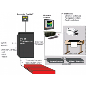
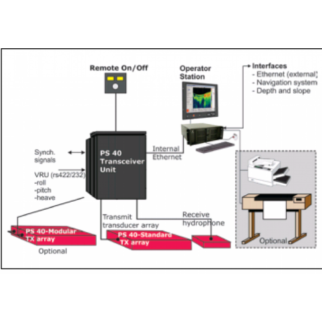
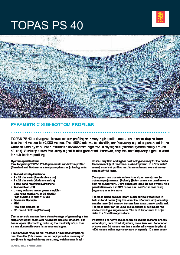
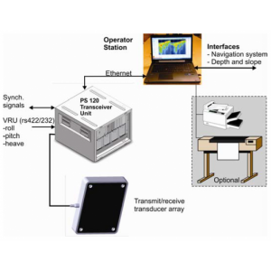
TOPAS PS 40
SUB BOTTOM PROFILER
The system is designed for sub-bottom profiling with very high spatial resolution in water depths from <4 meters to >2,000 meters.

Kongsberg Discovery
Horten, NO
Description
FEATURES:
• High resolution
• Wide frequency range
• CW and FM chirp
• Roll and pitch stabilisation in realtime
• Narrow acoustic beam
• Short pulse lengths and large bandwidth
• No sidelobes
• Single ping, multi ping and burst ping modes
• Easy to install
• Accurate location of object
• Compact system
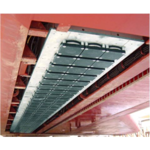
• Hull unit
Do you have questions about this product?
- Questions about price, availability, and/or retailers
- Questions about technical specifications and usage
- Questions about suitability for your project or application
Specifications
-
Mode of operation
-
Operating System
Windows
Min. depth of operation [m]
5
Max. depth of operation [m]
2000
Min. frequency [Hz]
1000
Max. frequency [Hz]
45000
Power output [W]
18000
Max. resolution [m]
0.10
Max. penetration [m]
80
Max. pulse rate [Hz]
20
Max. pulse length [s]
0.1
Dynamic range [dB]
110
Pitch corrected
Y
Roll corrected
Y
Heave corrected
Y
Platform type
Hull Mounted, Side Mounted
Signal composition
Broadband, Chirp, Single Frequency
Frequency
Wide band
-
General
-
Product type
Parametric sub-bottom profiler
Year of initial development
1992
Application
High Resolution
Max power consumption [W]
3000
Power type
AC
Transducer weight [kg]
80
Transducer length [m]
0.84
Transducer width [m]
0.53
Transducer height [m]
0.12
Weight of logging unit [kg]
120
Length of logging unit [m]
0.57
Width of logging unit [m]
0.6
Height of logging unit [m]
0.82
Portability of logger
Rack
Components to be used in combination with product
GPS, MRU, Echosounder (EM-Multibeam)
-
Integration in work process
-
Remote operation
Y
External heave input
Y
External roll input
Y
External pitch input
Y
External positioning input
Y
Marking of events
Y
Real time coupling to survey software
Y
Coupling to post-processing software
Y
-
Data Processing
-
Data displayed
Navigation, attitude, depth, PSD, vertical/horizontal distances, slope.
Data output
Raw and processed data
Formats
Kongsberg .raw and SEG-Y
Internal logging
Hard drive
Post-processing
Digital bandpass filterSpiking deconvolution/Matched FilterTime Varying Filter (TVF)Bad trace removalDereverberationTime Variable Gain (TVG)Automatic Volume Control (AVC)Stacking (Trace mixing)Swell filterManual/automatic gainAttribute processingStatisticsPower Spectral Density (PSD)
Connections
LAN, Monitor, Printer, RS232, USB, VGA
Documents
Brochure
kongsberg-geoacoustics-topas-ps-40-data-sheet.pdf
1.32 MB


