

Seapath 385
GNSS aided Inertial Navigation System
The all-new Seapath 385 is based on the legacy of the Seapath 300-series and incorporates new hardware and advanced navigation algorithms. The Seapath 385 is developed specifically for hydrographic surveying where high-precision heading, position, velocity, roll, pitch, heave and timing are critical measurements. Our solution combines state-of-the-art inertial technology and processing algorithms with multi-frequency GPS, GLONASS, Galileo, Beidou, QZSS and geostationary satellite signals.

Kongsberg Discovery
Horten, NO
Description
Sensor fusion
The advanced Seapath sensor fusion algorithms integrate raw inertial sensor data from our unique and very high-performance MGC® (Motion Gyro Compass) or MRU (Motion Reference Unit), together with raw GNSS data and RTK, PPP or DGNSS corrections. Our unique navigation algorithms enable high accuracy position output even when no correction signals are available.
Robust against GNSS dropouts
The Seapath is robust against GNSS dropouts by using the inertial sensor for dead reckoning navigation, providing all measurements even when GNSS is not available. The updated navigation algorithms ensure market leading dead reckoning performance. The Seapath 385 adds another layer of robustness in the unique use of both GNSS antennas for positioning in addition to heading.
Post-processing of the Seapath data is possible to further enhance accuracy in position and attitude. The Seapath 385 includes a new post-processing format that contains all necessary data and system configuration in a single file. Centimetre position accuracy can be achieved through downloaded satellite orbit and clock data or data logged from base stations.

System configuration
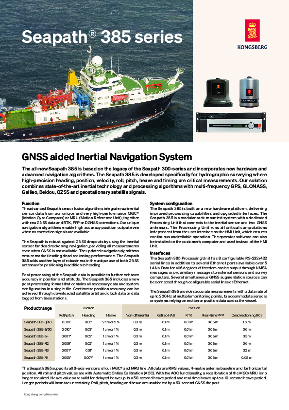
The Seapath 385 is built on a new hardware platform, delivering improved processing capabilities and upgraded interfaces. The Seapath 385 is a modular rack-mounted system with a dedicated Processing Unit that connects to the inertial sensor and two GNSS antennas. The Processing Unit runs all critical computations independent from the user interface on the HMI Unit, which ensures continuous and reliable operation. The operator software can also be installed on the customer’s computer and used instead of the HMI Unit.
The Seapath 385 Processing Unit has 8 configurable RS-232/422 serial lines in addition to several Ethernet ports available over 5 LANs. Data for all 6 degrees of freedom can be output through NMEA messages or proprietary messages to external sensors and survey computers. Several simultaneous GNSS augmentation sources can be connected through configurable serial lines or Ethernet. The Seapath 385 provides accurate measurements with a data rate of up to 200 Hz at multiple monitoring points, to accommodate sensors or systems relying on motion or position data across the vessel.
Key features
0.005° to 0.015° roll & pitch accuracy depending on MRU/MGC
1 cm/1% real-time heave accuracy for heave periods up to 10 seconds
1 cm/1% delayed heave accuracy by use of PFreeHeave® algorithm for heave periods up to 50 seconds
Dual 555-channel multi-frequency, multi-constellation receivers
All available GPS/GLONASS/Galileo/BeiDou/QZSS satellites used in position solution
RTK, Galileo HAS, Fugro G4/G4+ and more corrections supported
Includes SBAS corrections (WAAS, EGNOS, MSAS, GAGAN)
Includes unique high-precision non-differential position algorithm
Spoofing detection and rejection capabilities
All data have the same time stamp and to an accuracy of 0.001 s to the actual measurement time
Precise Time Protocol (PTP) and NTP available for time critical applications over Ethernet
Data available in up to eight different monitoring points
Up to 16 configurable output ports on Ethernet or serial line
Logging of raw satellite and IMU data possible
Remote support capabilities
Do you have questions about this product?
- Questions about price, availability, and/or retailers
- Questions about technical specifications and usage
- Questions about suitability for your project or application
Documents
Brochure
Datasheet_seapath385_feb24.pdf
1023.75 KB


